
Integrating Satellite Data for Nature-Positive Corporate Strategy: 衛星画像が拓く、ネイチャーポジティブな未来像

Flying satellites are becoming more and more commonplace. However, it seems that for many companies, the use of satellite data has yet to be integrated into their daily operations. In particular, for nature-positive applications, it seems that there are significant hurdles to overcome, as it is necessary to consider things like habitat assessments of water and biodiversity, which are difficult to measure directly using satellite data alone.However, by overcoming various challenges, we are beginning to see a path forward that will enable companies to use satellite data "smoothly" (without friction). This is what we have summarized in this report today. We hope you enjoy today!
空飛ぶ人工衛星がどんどん身近になってきています。しかし、まだまだ、多くの企業にとって衛星データの活用は日常業務に溶け込んでいないと思われます。特に、ネイチャーポジティブ用途では、衛星データだけでは直接測定が困難な水や生物多様性を「生息地(ハビタット)」などの評価も、考えねばならず、なかなか壁がありそうです。
一方で、様々な課題を克服し、企業が衛星データを「さくさく(摩擦なく)」使いこなすための道筋も見え始めています。今日はこの辺りをレポートでまとめています。今日も楽しんでいってくださいね!
Briefing Document: Integrating Satellite Data for Nature-Positive Corporate Strategy
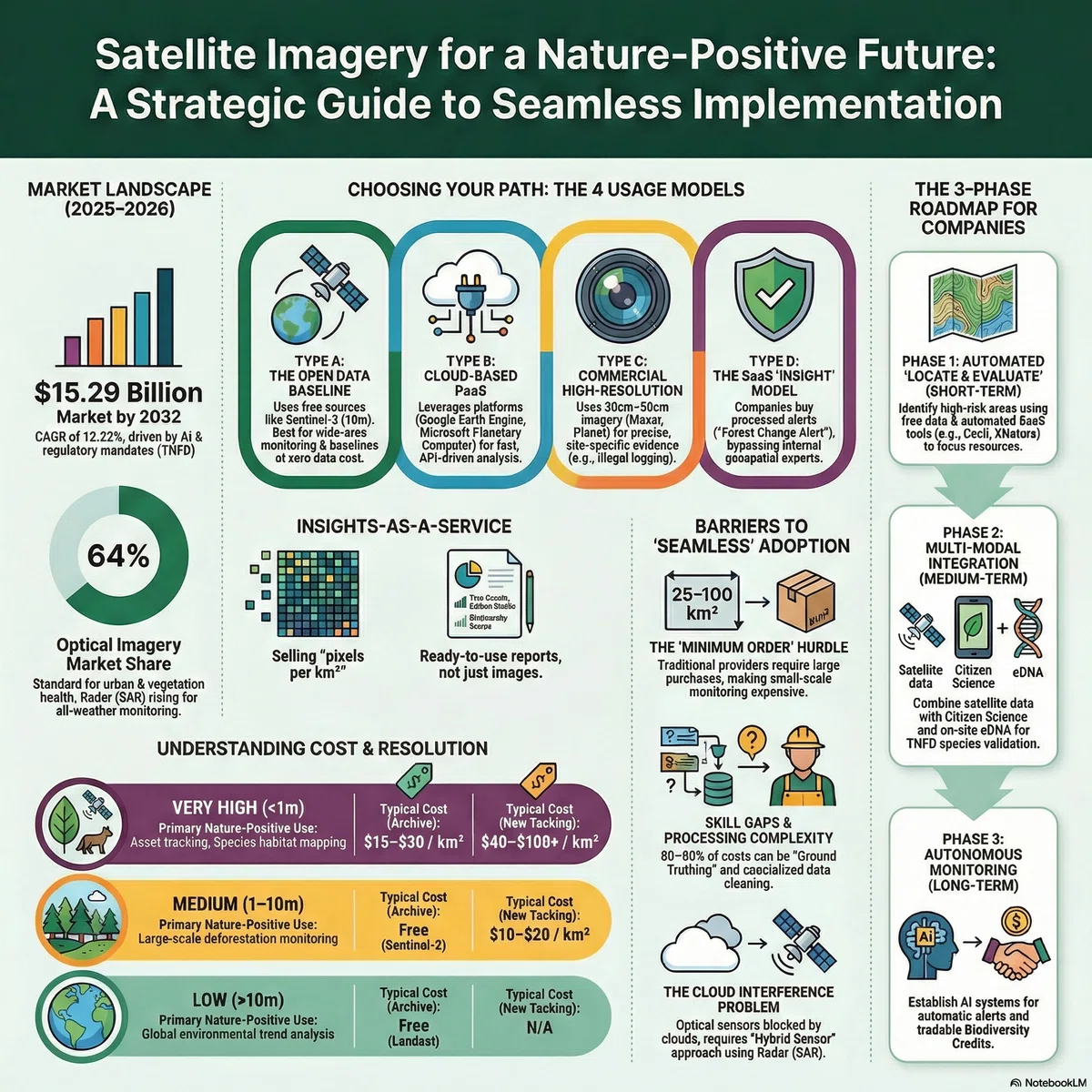
The corporate imperative is expanding from carbon neutrality to the more complex domain of being "nature-positive," a shift demanding evidence-based management of biodiversity and ecosystem impacts. Satellite earth observation (EO) data has emerged as the critical enabler for this transition, with a market experiencing explosive growth and increasing data accessibility through open-source programs and new commercial models. However, a significant corporate usability gap persists, driven by the technical complexity of data processing, the high cost of ground-truth validation, and an internal skills shortage. This gap is now being bridged by a new generation of solutions, primarily AI-driven Software-as-a-Service (SaaS) platforms that transform raw satellite imagery into decision-ready insights. To capitalize on this opportunity, corporations must move beyond ad-hoc data purchases and adopt a strategic, phased action plan: beginning with SaaS-based risk screening, building internal capabilities through training and partnerships, and ultimately integrating automated, multi-source monitoring into core business systems to drive transparency and build a resilient, competitive advantage in the nature-positive economy.
The New Imperative: From Carbon Neutral to Nature-Positive
For decades, corporate sustainability has been dominated by the pursuit of carbon neutrality. Today, a new, more intricate paradigm has taken center stage: the transition to a "Nature-Positive" economy. This global movement, codified by frameworks like the Kunming-Montreal Global Biodiversity Framework (GBF), calls on businesses to halt and reverse nature loss. The strategic stakes are immense; the World Economic Forum estimates that over half of the world's GDP is moderately or highly dependent on nature, making ecosystem degradation a direct financial risk.
Navigating this new landscape requires a new class of business intelligence—objective, scalable, and verifiable. Satellite earth observation (EO) data is the indispensable evidence-based tool for this task, offering the unique ability to monitor supply chains, assess environmental impacts, and verify conservation efforts across vast and remote geographies. Historically, however, significant barriers such as high costs, complex data processing, and the need for specialized expertise have kept this powerful resource out of the hands of most corporate decision-makers. This is rapidly changing as the satellite data market undergoes a profound technological and commercial revolution.
The Satellite Data Revolution: A Landscape of Growing Accessibility
Understanding the current satellite data market is no longer a niche technical concern; it is a strategic imperative. The market has transformed from an exclusive domain of governments and specialized agencies into a democratized source of business intelligence, driven by unprecedented growth and fundamentally new business models.
1 Market Growth and Key Drivers
The commercial satellite imagery market is on a steep growth trajectory, projected to expand from approximately USD 6.82 billion in 2025 to USD 15.29 billion by 2032. This expansion is fueled by several key drivers:
Advancements in Artificial Intelligence (AI): AI and machine learning are automating the complex analysis of petabyte-scale datasets, enabling near-real-time insights without manual intervention.
The Rise of Small Satellite Constellations: Companies like Planet operate hundreds of small satellites that can image the entire landmass of the Earth daily, shifting monitoring from a static, periodic activity to a dynamic, continuous process.
"Geospatial Intelligence-as-a-Service": A strategic shift is underway from selling raw data to providing subscription-based analytical services, which lowers the barrier to entry for non-specialist corporate users.
While growth is strong, corporate strategists must note that the government and defense sectors remain the dominant customers, accounting for over 65% of the market. This high demand can create a "crowding out" effect, leading to potential price pressure or supply constraints for the high-resolution imagery often sought for civilian and corporate applications.
2 The Democratization of Cost and Access
The traditional business model for satellite imagery was defined by high barriers. It was characterized by opaque pricing, significant Minimum Order Quantities (MOQs) often starting at 25-100 km², and per-kilometer costs ranging from $15 to over 100 for newly captured high-resolution images, with a common benchmark of **20-30/km² for high-resolution archives**. This structure made small-scale or exploratory projects prohibitively expensive.
Today, a new ecosystem of flexible and accessible models has emerged:
Subscription Models: Providers like Planet offer subscription-based access, allowing companies to monitor specific areas of interest with unlimited imagery for a predictable flat fee, aligning costs with operational budgets.
API-Driven Platforms: Marketplaces such as SkyWatch and government-led platforms like Japan's Tellus use APIs to eliminate MOQs entirely. This allows users to purchase imagery for very small areas—sometimes just a few square kilometers—on demand, making it affordable to investigate specific risk alerts.
Freely Available Open Data: The foundation of this new accessibility is the vast archive of free, medium-resolution government data. Europe's Copernicus Sentinel program (providing 10m resolution imagery) and the U.S. Landsat program (30m resolution) offer cost-free, analysis-ready data perfect for baseline assessments and large-scale screening.
While data is more accessible than ever, this availability has exposed a new set of challenges that prevent companies from effectively translating raw pixels into strategic action.
The Corporate Usability Gap: Why Actionable Insight Remains Elusive
Despite the democratization of data access, significant operational barriers prevent most companies from seamlessly converting satellite data into business decisions. The journey from raw imagery to actionable insight is fraught with technical, financial, and organizational hurdles.
1 Technical Complexity and Processing Burdens
Raw satellite data is not a simple photograph; it is complex sensor data requiring substantial pre-processing before it can be analyzed. This technical burden has traditionally been a major obstacle.
Essential Corrections: Data must undergo geometric correction to align with maps and atmospheric correction to remove the effects of clouds, haze, and aerosols.
Massive Data Volumes: Earth observation datasets are measured in petabytes. Handling, storing, and processing this volume requires significant cloud computing infrastructure and data engineering expertise.
Specialized Software & Skills: These processing steps have historically required expensive, specialized GIS software and the expertise of a remote sensing professional to execute correctly.
2 The "Last Mile" Problem: The High Cost of Ground-Truthing
Satellite data provides a powerful top-down estimate, but its accuracy must be validated with on-the-ground data—a process known as ground-truthing. This "last mile" of data validation is a critical but often overlooked challenge. It is a labor-intensive process that can involve dispatching teams for field surveys, deploying drones, or analyzing local datasets. In many environmental monitoring projects, the labor-intensive cost of ground-truthing can significantly outweigh the cost of the satellite imagery itself, creating a major financial and operational barrier.
3 The Personnel and Skills Gap
The most significant bottleneck for many organizations is the lack of in-house expertise. Without specialists in remote sensing and geographic information systems (GIS), companies struggle to:
Select the appropriate satellite sensor and resolution for their specific business question.
Perform the necessary analysis and interpret the results correctly.
Understand the limitations and uncertainties inherent in the data.
This skills gap prevents organizations from moving beyond simple viewing of imagery to integrating geospatial intelligence into their core workflows.
4 Data Reliability and Interpretation Challenges
Different satellite sensors have inherent limitations that create practical business challenges and require careful management.
Optical Imagery: While intuitive to interpret, optical sensors are functionally cameras in space. They cannot see through clouds—a major issue in persistently cloudy tropical regions—and are unable to capture imagery at night.
SAR (Radar) Imagery: Synthetic Aperture Radar (SAR) is a powerful alternative that can penetrate clouds and operate day or night. However, SAR imagery is not intuitive and requires significant specialist knowledge to interpret correctly, making it less accessible for general business users.
Overcoming these usability challenges is not just a technical exercise; it is strategically vital for companies committed to making credible, data-driven nature-positive commitments.
A Strategic Asset for Nature-Positive Management
When the usability gap is bridged, satellite data transforms from a complex technical tool into a core strategic asset for meeting modern ESG, regulatory, and operational demands. Its capabilities align directly with the key frameworks and business applications driving the nature-positive agenda.
1 Aligning with Global Frameworks (TNFD & SBTN)
Satellite data is essential for implementing the leading frameworks for nature-related management, particularly the Taskforce on Nature-related Financial Disclosures (TNFD) and its recommended LEAP approach.
Locate: Companies can use free, medium-resolution satellite data to screen thousands of supply chain locations against global maps of protected areas and biodiversity hotspots, efficiently identifying priority areas for deeper investigation.
Evaluate: Time-series satellite imagery allows for the direct quantification of ecosystem change. Companies can measure historical rates of deforestation, land conversion, or wetland degradation associated with their operations and value chains.
Assess & Prepare: Satellite-derived models for physical risks, such as floodplains or wildfire susceptibility, provide critical inputs for financial risk assessments and inform corporate disclosure and response planning.
Similarly, satellite data provides the primary, and often only, means of verifying compliance with land-based Science Based Targets for Nature (SBTN), such as the foundational target of "No conversion of natural ecosystems."
2 Key Application: Supply Chain Monitoring and Deforestation
One of the most mature applications of satellite data is in ensuring supply chain transparency and combating deforestation. As shown in the image below of a deforestation monitoring platform, areas of recent forest loss can be automatically highlighted (in orange), allowing companies to quickly identify and manage risks associated with specific suppliers or sourcing regions.
Leading global companies are already embedding this technology into their operations. Ferrero, Nestlé, and PepsiCo use services from providers like Airbus and Satelligence to continuously monitor their palm oil, cocoa, and sugarcane supply chains, providing objective, third-party evidence to verify their "No Deforestation" commitments to investors and consumers.
3 The Biodiversity Challenge: The Limits of Proxy Indicators
Unlike CO₂, which has a single, universal metric (t-CO₂e), biodiversity is multifaceted and cannot be measured with a single indicator. It is crucial for decision-makers to understand that satellites cannot directly "see" individual species or count them from orbit. Instead, they measure critical proxy indicators of biodiversity, such as:
Habitat Extent: The total area of a given ecosystem (e.g., forest, wetland).
Habitat Integrity: The condition of that ecosystem, including factors like fragmentation (how broken up it is) or vegetation health.
By monitoring these proxies, companies can effectively track the pressures on biodiversity and the health of the habitats upon which species depend. This sets a realistic expectation for what satellite data can deliver and underscores the need to combine it with other data sources.
From Raw Data to Ready Decisions: The New Generation of Solutions
A wave of technological and business model innovation is closing the corporate usability gap, making satellite-derived insights more accessible, affordable, and actionable than ever before. These solutions are designed to make data effortlessly usable by non-experts.
1 The Shift to SaaS: From Imagery to "Insights-as-a-Service"
The most significant change is the shift away from selling raw imagery files. The new dominant model is Software-as-a-Service (SaaS), where platforms deliver "Insights-as-a-Service."
These platforms, offered by companies like Gentian, XNatura, and Kanop, handle all the complex backend processing—data acquisition, correction, and analysis. Corporate users interact with a simple web-based dashboard that presents decision-ready information, such as biodiversity scores, carbon stock estimates, or risk alerts for their specific assets. This model completely removes the need for in-house GIS experts, specialized software, or powerful computing infrastructure, turning satellite intelligence into a predictable operational expense.
2 The AI Revolution: Automating Analysis and Conversation
Artificial Intelligence is the engine driving this new generation of solutions.
Automated Change Detection: AI and machine learning algorithms work continuously in the background to analyze incoming satellite data, automatically detecting changes like deforestation, construction, or water body shrinkage. Services like Global Forest Watch use this technology to provide free deforestation alerts to users worldwide.
Generative AI ("Chat with your map"): A revolutionary new interface is emerging that allows non-technical users to query vast archives of geospatial data using natural language. Instead of complex code or GIS commands, a user can simply ask, "Show me all areas in my supply chain that have experienced more than 10% tree cover loss in the last year." This "conversational GIS" dramatically lowers the skill threshold required to extract value from data.
3 The Power of Platforms and Open Ecosystems
Integrated platforms are creating powerful ecosystems that bring together data, analytical tools, and expertise, further reducing barriers for individual companies.
Cloud Analytics Platforms: Services like Google Earth Engine and Microsoft's Planetary Computer provide access to petabytes of analysis-ready satellite data and the immense computing power needed to process it. This eliminates the need for companies to build and maintain their own costly data storage and processing infrastructure.
The Japanese Ecosystem Example: Japan provides a powerful model of a public-private ecosystem designed to accelerate adoption.
The government-led Tellus platform offers a centralized hub for accessing a wide range of satellite data and provides extensive training and e-learning resources to build foundational skills.
An innovative partnership between corporate giant NTT and the startup Biome showcases the power of data fusion. By combining satellite imagery with millions of citizen-science species observations collected via Biome's mobile app, they are creating a highly accurate and cost-effective biodiversity monitoring system. This model directly addresses the "last mile" ground-truthing challenge—which can account for the majority of a monitoring project's cost—by innovatively leveraging citizen science as a scalable, cost-effective alternative to traditional field surveys.
These solutions are not futuristic concepts; they are available today and provide the foundation for a concrete corporate action plan.
Conclusion: The Time for Geospatial Intelligence is Now
The historic barriers of prohibitive cost and technical complexity that once locked satellite data away from the corporate world are rapidly diminishing. Innovations in AI, cloud computing, and "Insights-as-a-Service" business models have democratized access to this critical source of intelligence. In this new landscape, perfection should not be the enemy of progress. The imperative for corporate leaders is not to wait for a flawless, all-encompassing dataset, but to act now. By embracing the "best available data" to understand and manage their nature-related risks and opportunities, companies can take the essential first steps. This proactive approach will not only build operational resilience and ensure regulatory compliance but also forge a significant competitive advantage in the emerging nature-positive economy. The time for geospatial intelligence is now.
ネイチャーポジティブ経営のための衛星データ活用戦略:現状、課題、および実践的導入ロードマップ
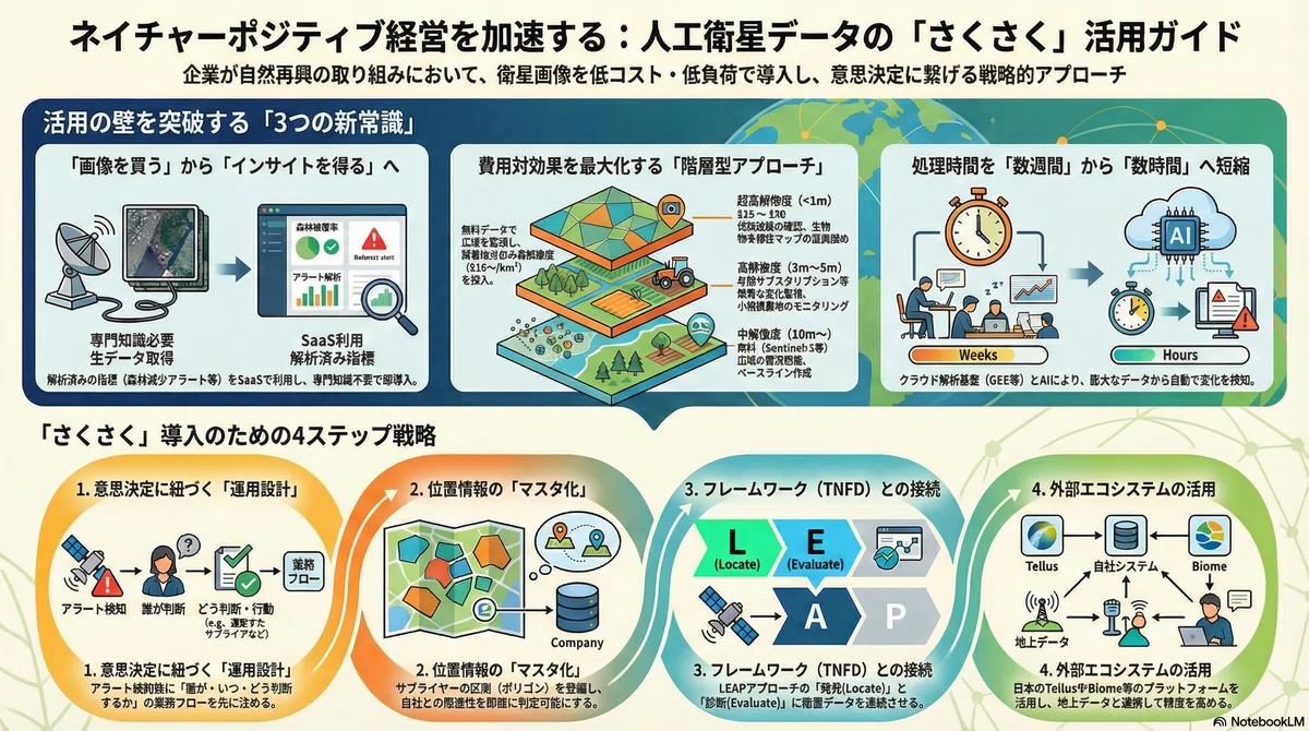
衛星データ活用の現状:進化する技術と多様化するアクセス手法
今日の企業が利用可能な衛星データの選択肢は、かつてないほど多様化しています。技術の進歩とビジネスモデルの革新により、あらゆる企業が自社の目的と予算に合わせて最適なデータソースを選べる時代が到来しました。このセクションは、意思決定者が自社の課題解決に最適なツールセットを理解するための基礎知識を提供します。
利用可能な衛星データは、主にその特性によって分類できます。それぞれのビジネス上の価値は以下の通りです。
光学衛星(無料・中解像度): 欧州のSentinelや米国のLandsatが代表例です。Sentinelは10m解像度で5日ごと、Landsatは30m解像度で16日ごとに観測を行い、広域の土地被覆や植生の変化を把握するベースライン分析において、極めて高い費用対効果を発揮します。TNFDの初期段階であるリスク地域のスクリーニングに最適ですが、雲の影響を受けやすく、熱帯地域などでは観測できない期間が生じるという制約があります。
光学衛星(商用・高解像度): MaxarやPlanetなどが提供する30cm~50cm級の超高解像度データは、個別のインフラや小規模な土地改変、さらには大きな樹木の識別さえ可能にします。これにより、サプライヤーの施設や農地で起きた変化を詳細に確認できるため、監査やデューデリジェンスにおける客観的な「証拠」としての役割を担います。
合成開口レーダー(SAR): 自らマイクロ波を発信して地表を観測するため、雲や夜間でも観測可能な全天候型の利点を持ちます。特に雲に覆われがちな熱帯雨林地域における森林破壊の監視や、洪水などの災害管理において光学データを補完する重要な役割を果たします。ただし、その画像は直感的な解釈が難しく、分析には専門的な知識が必要となる場合があります。
これらのデータへのアクセス方法も、企業のニーズに合わせて進化しています。
伝統的な都度購入モデル: 1平方キロメートルあたりの単価と、小規模な検証(スモールスタート)を妨げる「最低注文面積(MOQ)」という制約が大きな障壁となってきました。
サブスクリプションモデル: 特定の関心地域を対象に、データを定額で利用できるモデルです。継続的なモニタリングと予算計画を容易にし、都度購入よりも割安になる場合があります。
API経由の小口購入・プラットフォーム利用: SkyWatchのようなマーケットプレイスや、日本のTellusのようなプラットフォームは、MOQの壁を取り払い、企業が必要な分だけを低コストで購入することを可能にしました。
「インサイト・アズ・ア・サービス」(SaaS): 企業が画像そのものではなく、AIによって解析済みの「洞察」や「アラート」を月額課金などで購入するモデルが主流になりつつあります。これは、社内にリモートセンシングの専門家がいない企業にとって、最も導入しやすい現実的な選択肢と言えます。
これらの選択肢が多様化したにもかかわらず、多くの企業が衛星データの実用化に至らない背景には、依然として根深い構造的な障壁が存在します。
導入を阻む構造的障壁:コストと「手間」の正体
衛星データ活用の民主化が進む一方で、多くの企業でその本格導入が進まない根本原因は、コストと手間の構造的な問題にあります。これらを理解することは、現実的で持続可能な導入計画を策定する上での第一歩です。
衛星データ活用に伴うコストは、以下の3つです。
データ購入費: 無料データが存在する一方で、TNFD開示やEUDR対応で求められる証拠能力の高い高解像度データには、依然としてコストがかかります。アーカイブデータ(過去画像)でさえ1km²あたり15~30、新規撮影を依頼する場合は40~100以上に達することもあります。さらに過去には「最低注文面積(MOQ)」の制約により、たとえ数ヘクタールの農地を監視したい場合でも、25km²や100km²といった単位で購入する必要がありました。この構造が小規模な検証を阻んできたのです。
計算・インフラ費: Google Earth Engine (GEE) のようなクラウド基盤を利用すれば、初期の概念実証(PoC)は比較的安価に行えます。しかし、本格運用に移行し、監視対象の面積や頻度が増加するにつれて、月額の基盤利用料や処理量に応じた従量課金が大きくなる構造を理解しておく必要があります。
人件費: 最も見過ごされがちですが、最終的に最大のコストとなり得るのが人件費です。サプライチェーンの地理情報の整備、解析モデルの構築・運用、そして解析結果の検証や監査対応など、各工程で専門スキルを持つ人材が必要となります。この「見えないコスト」が、プロジェクト全体の費用を押し上げる最大の要因です。
企業が直面する「手間」を、具体的な業務に沿って見てみましょう。
データの前処理: 衛星画像は、一般的なデジタル写真とは異なり、解析前に専門的な処理を必要とします。地形による歪みを補正する「幾何補正」、大気中の塵や水蒸気の影響を取り除く「大気補正」、そして解析の邪魔になる「雲除去」といった工程は、専門家でない担当者にとって最初の高い壁となります。
サプライチェーンの地理情報整備: これが実務上、最も大きなボトルネックです。監視対象となるサプライヤーの農地や工場の正確な位置情報(ポリゴンデータ)がなければ、衛星で森林破壊を検知しても、それが自社のサプライチェーンと関連があるのかを評価できません。EUDRのような規制は、この地理情報(ジオロケーション)の提出を必須要件としており、企業はこのデータ整備に多大な労力を投じる必要があります。
精度検証と業務への統合: 衛星解析には、誤検知(false positive)が付き物です。解析結果を鵜呑みにすることはできず、「アラートが発生した場合に、現地調査やサプライヤーへの確認を通じて事実確認を行う」という業務プロセスが不可欠です。この「グラウンドトゥルース(地上検証)」を得るための体制を構築し、維持することに多大な労力がかかります。
このように、コスト構造と手間の本質を理解すれば、戦略が「全方位を最高技術で監視する」ことから、「リスクの高い領域に絞り、最適なデータを組み合わせて運用する」ことへと自然に移行するのです。次のセクションでは、その具体的な活用法を詳述します。
ネイチャーポジティブ経営における戦略的活用法
前述の障壁を乗り越える価値は、衛星データがTNFDなどの開示要請やサプライチェーン管理といった具体的な経営課題に対し、いかに実践的な解決策を提供できるかにあります。
TNFDが推奨する「LEAPアプローチ」は、企業が自然関連リスクを評価・管理するための皆様のお馴染みなフレームワークですが、衛星データはその各段階でそれぞれ役立ちます。
Locate(発見): サプライチェーン上に存在する数千、数万の拠点が、生物多様性重要地域や原生林といった高リスクなエリアに存在するかどうかを特定する段階です。ここでは、広域をカバーする無料の衛星データ(Sentinel等)を用いて、網羅的なスクリーニングを行い、優先的に監視すべきエリアを絞り込みます。
Evaluate(診断): Locateで特定された高リスク地域において、自然への影響と依存度を診断します。衛星データの時系列分析により、過去数年間でどれだけの森林が減少したか、生態系の状態がどう変化したかを定量的に評価し、具体的な影響面積を算出します。
Assess(評価)とPrepare(準備): Evaluateで得られた定量的な分析結果は、事業リスクの財務的評価や、投資家・規制当局への報告における客観的な「証拠」として機能します。衛星データに基づく具体的な数値は、企業の主張の信頼性を高め、ステークホルダーとの対話を円滑にします。
ネイチャーポジティブ分野における具体的な活用事例は、すでに先進企業で始まっています。
サプライチェーンにおける森林破壊の監視: Nestlé、Ferrero、PepsiCoといった多くの食品・消費財企業は、StarlingやSatelligenceといった専門プラットフォームを利用し、パーム油、カカオ、大豆といった原材料の調達先における森林破壊を継続的に監視しています。これらのプラットフォームは衛星画像を自動解析し、担当者がダッシュボード上でリスクを即座に把握し、サプライヤーへの是正措置やリスク評価レポートの作成に繋げることを可能にします。
生物多様性のモニタリング: 衛星データで生物種そのものを直接識別することは困難です。しかし、生物多様性の基盤となる生態系の生息地(ハビタット)の広がり、質、そして分断化の状況をマッピングすることで、生物多様性の状態を示す極めて有効な「代理指標」となります。Gentian社のような専門企業は、AIを用いて高解像度衛星画像を解析し、詳細なハビタットマップを作成することで、企業のTNFD、CSRD、BNGといった枠組みへの報告を支援しています。
これらの戦略的活用の重要性を踏まえ、企業が具体的にどのようなステップを踏んで導入を進めるべきか、次のセクションで実践的なロードマップを提示します。
実践的導入プラン:企業が「さくさく使う」ためのアクション
企業が衛星データを絵に描いた餅に終わらせず、さくさく使うためのアクションを考えてみましょう。成功の鍵は、最新技術の選定そのものよりも、むしろ戦略的な運用設計にあります。
企業が衛星データ活用を成功させるためには、以下の4つの必須要件を組織内に確立する必要があります。
1. 意思決定に紐づく運用設計: 最も避けるべきは「監視して終わり」の状態です。「森林減少アラートが出たら、何日以内に、どの部署の誰が、サプライヤーに何を確認し、どのような判断を下すのか」という具体的な業務プロセスを、技術導入の前に定義することが最重要です。
2. サプライチェーン地理情報のマスターデータ化: 全ての分析の土台となるのが、取引先の工場の位置や農地の区画といった地理情報です。これらの情報を調達データと紐づけて一元管理する「ロケーション・マスター」を構築しなければ、衛星で検知した変化が自社に与える影響を評価することはできません。
3. リスクベースのアプローチ採用: 全てのサプライチェーンを最高解像度で監視するのは、コスト的にも運用的にも非現実的です。原材料の種類、調達先の地域、取引額などに基づいてリスク評価を行い、高リスクなサプライヤーや地域に絞って監視の深度と頻度を高める戦略が、コストを抑制しつつ効果を最大化します。
4. ハイブリッドなデータ活用戦略: 最も費用対効果の高いアーキテクチャは、複数のデータソースを組み合わせるハイブリッド型です。「常時監視はGlobal Forest Watch(GFW)の無料アラートやSentinel等の中解像度データで行い、疑義が生じた地点の確認・監査にのみ商用の高解像度データをピンポイントで購入する」。これが、衛星データ活用の投資対効果を最大化する、現時点での唯一の現実解です。このアプローチにより、高解像度データは月間の利用上限面積(例:100km²)を定め、月額数万円から数十万円の範囲で証拠固めを行うといった予算管理が可能になります。
これらの要件を踏まえ、導入を成功させるための具体的な推奨アクションを以下に示します。
SaaSプラットフォームの活用: 自社でゼロから解析体制を構築する前に、まずはXNaturaやKanopのようなTNFD対応SaaSを導入し、「解析済みのインサイト」を購入することから始めるべきです。これにより、最小限の投資で迅速に価値を得ることができます。
国内エコシステムの活用: 日本企業は、政府主導のプラットフォーム「Tellus」で無料データを試用したり、ハンズオンセミナーに参加したりすることで、低リスクで知見を深めることができます。また、Biome社との連携は、衛星データの弱点である地上の生物種情報を、市民科学のアプローチで補完する先進的な取り組みであり、独自の競争優位性を築く上で有効な選択肢です。
段階的なスキル構築: 当面は外部サービスを活用しつつ、社内のサステナビリティ担当者向けにTellus Trainerのような研修プログラムを利用し、衛星データで「何が見え、何が見えないか」を正しく理解するリテラシーを徐々に高めていくことが、長期的な成功の基盤となります。
これらの実践的なステップを踏むことで、衛星データはも企業のネイチャーポジティブ経営を支える強力な武器となり得ます。
結論:未来への展望
本レポートで詳述したように、衛星データ活用の障壁は、SaaSプラットフォームの進化、AIによる解析自動化、そしてオープンデータ政策の拡充によって着実に低下しています。かつては政府や一部の大企業だけのものであった「宇宙の眼」は、今やあらゆる企業の手に届くツールとなりつつあります。
このような変革期において、企業にとっての成功の鍵は、完璧なデータや完璧な解析技術を待つことではありません。むしろ、「現在利用可能な最良のデータ(Best Available Data)」を用いて、まずは自社のサプライチェーンに潜む自然関連リスクの大枠を把握し、具体的な行動を開始することです。
衛星データは、もはや専門家だけのものではなく、全ての企業の意思決定を支え、事業の透明性を担保する基盤インフラへと進化しつつあります。ネイチャーポジティブ経済への移行が加速する中で、この変化へいち早く適応し、衛星データをどのように活用するかを思い巡らし、挑戦することは、未来の市場における事業のレジリエンス(防御)と競争優位性(攻勢)を確立する上でのツールとなるでしょう。
