Today, many applications deal with information that is related to locations, shapes, maps, and geographical features. A normal database cannot efficiently handle such location-based information. That’s where spatial data and spatial databases come into the picture.
Spatial Data
Spatial data is data that represents objects in physical space — anything that has a shape, size, or position on Earth.
Examples:
- A building shown on a digital map
- A road, river, or boundary line
- A satellite image
- The outline of a country, state, or city
Normal indexes (like B-Trees or hashing) cannot efficiently answer questions such as:
“Find all buildings that lie inside this area”
“Show all roads that intersect this route”
“Which houses are within 5 km of this point?”
To handle such queries, databases need special spatial index structures like R-trees.
Types of Spatial Data
1. Raster Data
Raster = grid of pixels (like a photo or image).
Each pixel has an associated value (color, elevation, temperature, etc.)
Examples:
- Satellite images
- Scanned maps
- Digital photos
- Heatmaps showing rainfall or temperature
Think of raster as an image divided into tiny squares.
2. Vector Data
Vector = geometric shapes that represent real-world objects.
Examples:
- Points → Location of ATM, hotel, shop
- Lines → Roads, rivers, pipelines
- Polygons → Buildings, countries, lakes
- 3D shapes → Cylinders, cuboids used in 3D modeling
Vector data is more precise and structured than raster data.
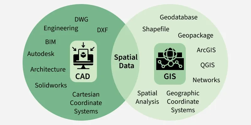
Spatial Data in Computer-Aided Design (CAD)
CAD is used to design:
- Machines
- Cars
- Buildings
- Aircraft
- Electronics (like integrated circuits)
Problems with old CAD systems:
- Data stored in memory during editing
- Everything had to be saved back to one big file
- Even if you needed only a small part, you had to read the whole file
- Large models (like an entire aircraft) couldn’t fit into memory
Solution: Object-Oriented Databases
OODBMS represent every component as an object.
Example:
- Engine → object
- Wing → object
- Inner parts → objects connected to each other
This makes the design more organized, efficient, and scalable.
Spatial Data in Geographic Information Systems (GIS)
GIS stores and manages geographical data, such as:
- Road maps
- Land usage maps
- Elevation maps
- Political boundaries
- Land ownership information
- Soil type maps
- Rainfall distribution maps
GIS data differs from CAD data:
- CAD focuses on designing objects
- GIS focuses on earth-related information like maps and satellite images
Applications
Microsoft SQL Server
Since SQL Server 2008, it supports spatial data types and spatial indexes.
You can store:
- Points
- Lines
- Polygons
And run queries like:
Find all locations within 10 km of this point.
CouchDB (with GeoCouch plugin)
CouchDB is a document-based NoSQL database.
GeoCouch plugin adds:
- Spatial indexing
- Geo-queries
- Location-based search
Neo4j
Neo4j is a graph database.
It handles spatial data mainly for:
- Pathfinding
- Routing (like GPS navigation)
- Graph-based map analysis
Example:
Find the shortest route between two locations.
