Log inSign up
NOAA Satellites
26.2K posts
user avatar
NOAA Satellites
@NOAASatellites
The NOAA Satellite & Information Service (referred to as NESDIS) is a line office of @NOAA.
Silver Spring, MD
nesdis.noaa.gov
Joined April 2009
645
Following
1.4M
Followers
  • user avatar
    NOAA Satellites
    @NOAASatellites
    Sep 14, 2018
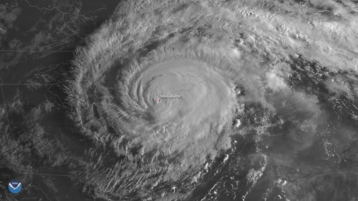
    #GOESEast captured these two dramatic views of #HurricaneFlorence shortly after the storm made landfall near Wrightsville Beach, NC this morning. Latest updates: go.usa.gov/xPYSG
    This image shows Hurricane Florence shortly after the storm made landfall near Wrightsville Beach, N.C.
    This image shows Hurricane Florence shortly after the storm made landfall near Wrightsville Beach, N.C.
  • user avatar
    NOAA Satellites
    @NOAASatellites
    Aug 30, 2019
    Watch as the eye of #HurricaneDorian2019 begins to form in this 1-minute visible loop from NOAA's #GOESEast. "Dangerous Hurricane #Dorian poses a significant threat to #Florida and the northwestern #Bahamas," according to the @NHC_Atlantic. Latest: go.usa.gov/xVB3K
    GIF
  • user avatar
    NOAA Satellites
    @NOAASatellites
    Dec 21, 2019
    Happy #WinterSolstice! To celebrate, we collected an image per day over the last year from #GOESEast, taken at 1200 UTC, and looped them together. You can really see how the seasons change from #equinox to #solstice due to the #Earth's 23.5° tilt.
    00:00
  • user avatar
    NOAA Satellites
    @NOAASatellites
    Aug 21, 2017
    Watch the moon's shadow move across the US in this geocolor loop from #GOES16! See more #SolarEclipse imagery @ goo.gl/vgGLMF
    00:00
  • user avatar
    NOAA Satellites
    @NOAASatellites
    Oct 9, 2024
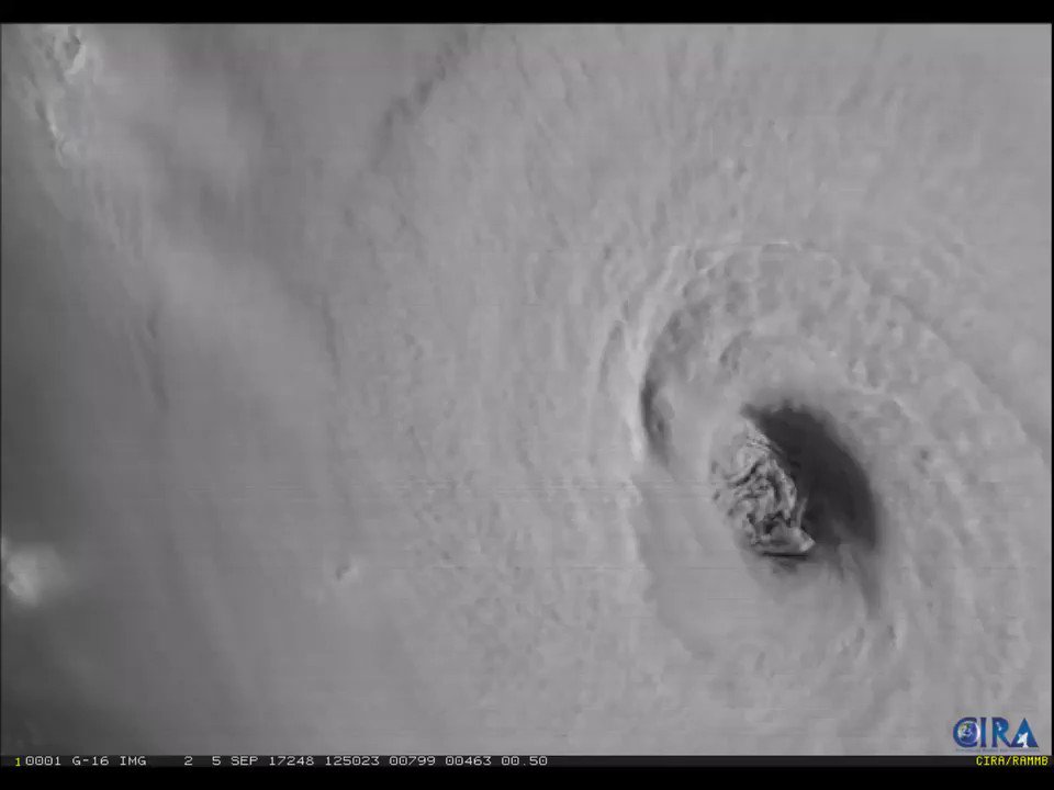
    This imagery from @NOAA's #GOESEast 🛰️ is providing visible cloud imagery every 30 seconds of #HurricaneMilton as it pushes closer to Florida. Notice the frequent #lightning being picked up by the satellite's #GLM instrument as well. Get the latest on #Milton:
    00:00
    user avatar
    National Hurricane Center
    @NHC_Atlantic
    Oct 9, 2024
    Hurricane #Milton Advisory 19: Milton Approaching the Coast of West-Central Florida. Life-Threatening Storm Surge, Damaging Winds, and Flooding Rains Expected Across Portions of Central and Southwestern Florida. hurricanes.gov
    1.5M
  • user avatar
    NOAA Satellites
    @NOAASatellites
    Dec 14, 2020
    Today's total #SolarEclipse was the only total solar #eclipse of the year. Although it was mainly visible from Earth in parts of South America, #GOESEast had a perfect view of the moon's shadow moving across the Earth.
    GIF
  • user avatar
    NOAA Satellites
    @NOAASatellites
    Sep 5, 2017
    Get a good look at Hurricane #Irma's eye with this visible imagery from #GOES16! For the latest info on Irma, go to nhc.noaa.gov
    00:00
  • user avatar
    NOAA Satellites
    @NOAASatellites
    Aug 29, 2021
    EYE OF A MONSTER: @NOAA's #GOESEast 🛰️ gives an up-close look at the lightning swirling around the eye of #HurricaneIda, a dangerous Cat. 4 #hurricane, nearing the coast of southeastern #Louisiana. Please stay safe! More: noaa.gov/ida #LAwx #MSwx #idahurricane #ida
    00:00
  • user avatar
    NOAA Satellites
    @NOAASatellites
    Aug 26, 2020
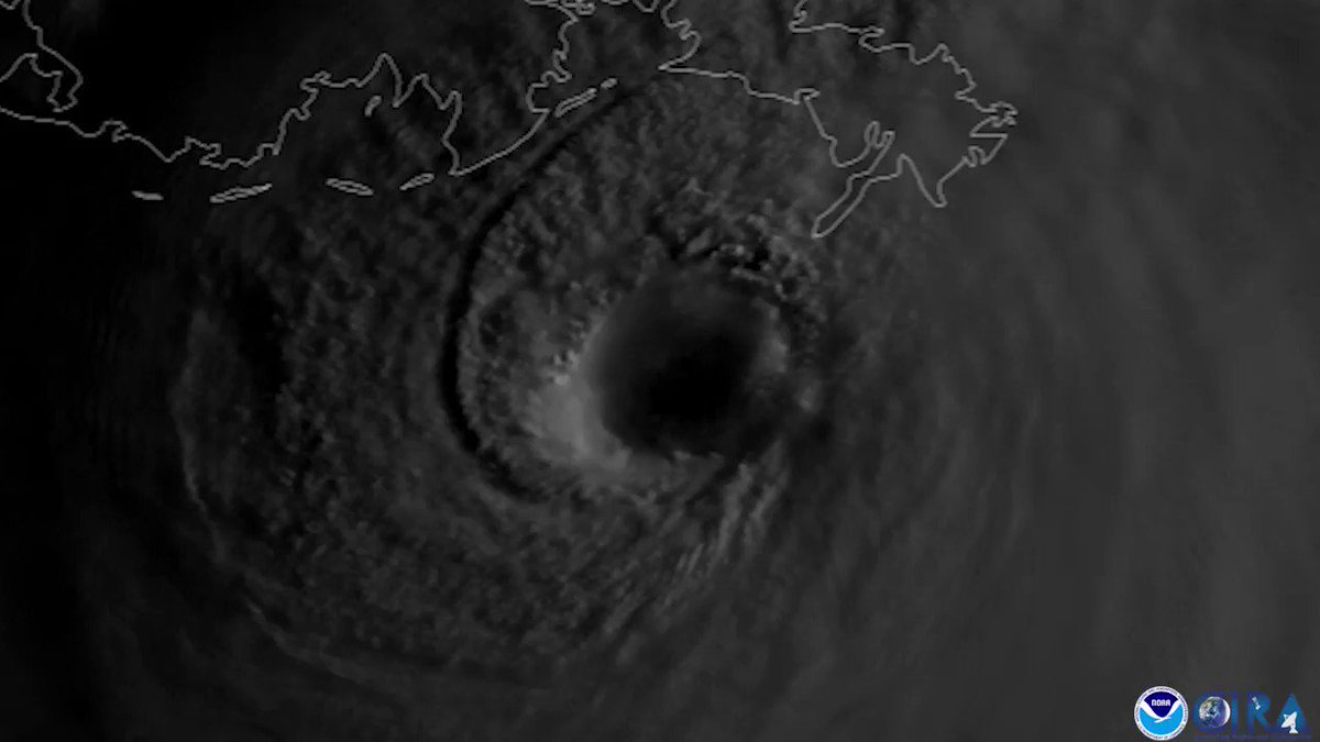
    For this #WednesdayMorning, take a look at #HurricaneLaura with @NOAA's #GOESEast satellite as the hurricane's convection bursts with lightning. As of 8 a.m. EDT, #Laura had winds of 115 mph and was rapidly intensifying in the Gulf of Mexico. Latest: nhc.noaa.gov
    GIF
  • user avatar
    NOAA Satellites
    @NOAASatellites
    Sep 11, 2018
    The #GOESEast satellite captured this close-up of the menacing eye of Category 4 #HurricaneFlorence this afternoon as the storm continues its trek toward the East Coast. Latest: go.usa.gov/xPrDD
    GIF
  • user avatar
    NOAA Satellites
    @NOAASatellites
    Sep 11, 2020
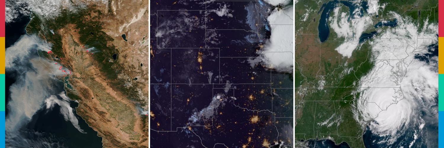
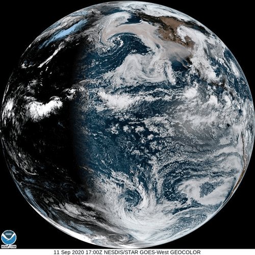
    This #FullDiskFriday, the #GOESWest satellite is continuing to watch the sobering amount of smoke from wildfires spreading across the #WestCoast of the U.S. @NIFC_Fire says there are 102 large wildfires and so far, more than 4 million acres have burned.
    GIF
  • user avatar
    NOAA Satellites
    @NOAASatellites
    Sep 28, 2022
    #GOESEast captured this incredible view of the inside of #Hurricane #Ian's eye as the storm approached Florida. Latest: noaa.gov/ian #FLwx
    00:00
  • user avatar
    NOAA Satellites
    @NOAASatellites
    Apr 8, 2024
    Watch a replay of the moon's shadow traveling across the path of totality, seen from @NOAA’s #GOESEast satellite. #TotalEclipse #Eclipse #Eclipse2024, #TotalEclipse2024 #NOAATotalEclipse2024, #2024Eclipse
    GIF
    257K
  • user avatar
    NOAA Satellites
    @NOAASatellites
    Aug 14, 2020
    Like the famous "Earthrise" photo taken from the #moon, this image, captured by @NOAA's #GOESWest 🛰️on March 6, 2020, shows the moon rising over the Earth. Can you see it? We hope you feel as lucky as we do to see this beautiful image on #FullDiskFriday and #FlashbackFriday!

New to X?

Sign up now to get your own personalized timeline!

Create account

By signing up, you agree to the Terms of Service and Privacy Policy, including Cookie Use.

Terms of Service|Privacy Policy|Cookie Policy|Accessibility|Ads info|© 2026 X Corp.
Don't miss what's happening
People on X are the first to know.
Log inSign up