Log inSign up
NWS St. Louis
43.2K posts
user avatar
NWS St. Louis
@NWSStLouis
Official Twitter account for the National Weather Service St. Louis. Details: weather.gov/nws_x
St. Charles, MO
weather.gov/lsx
Joined May 2012
414
Following
70.1K
Followers
  • user avatar
    NWS St. Louis
    @NWSStLouis
    5h
    Dry weather is expected on Saturday before showers and thunderstorms move into the area late Saturday night and Sunday. A few severe thunderstorms will be possible along with locally heavy rainfall. #stlwx #midmowx #mowx #ilwx
    There is a three panel forecast for Saturday, Saturday night, and Sunday with pictures for each period including clouds over a lake and thunderstorms.
    1.9K
  • user avatar
    NWS St. Louis
    @NWSStLouis
    21h
    Got plans this weekend? Dry weather likely lasts through Saturday, but rain chances ramp up on Sunday. The severe weather threat is currently low, but some locally heavy rainfall is possible.
    A table shows the rain chances over time at select sites across the area from Saturday through Monday. The higher chances are shown in darker shades of green.
    2.4K
  • user avatar
    NWS St. Louis
    @NWSStLouis
    Jun 18
    After a dry Friday, the chance for showers and thunderstorms will gradually increase over the weekend. While the best chance for rain will be late in the weekend, it is not expected to rain all day on Sunday. #stlwx #midmowx #ilwx #mowx
    There is a forecast for Friday through Sunday with weather symbols for lightning, rain, and clouds, and green shading indicating when there is a chance for rain.
    2.7K
  • user avatar
    NWS St. Louis
    @NWSStLouis
    Jun 18
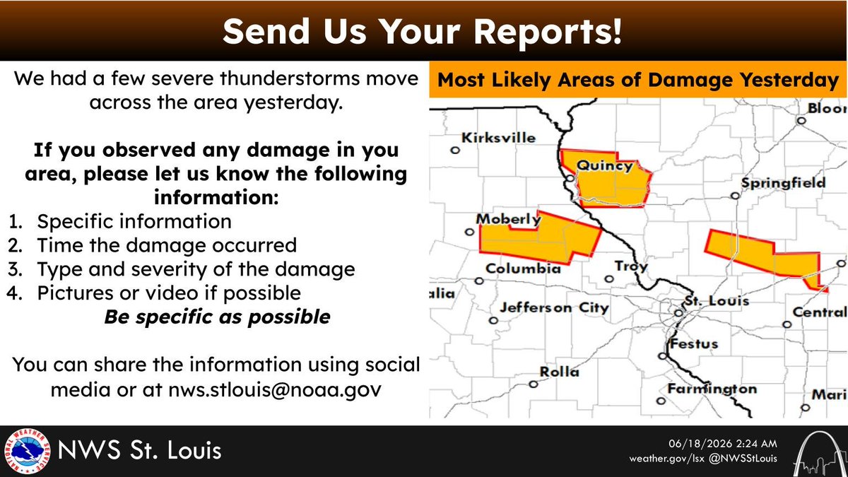
    If you observed any damage from severe thunderstorms yesterday, we would appreciate your report! You can share your report on social media or our email: [email protected] #stlwx #midmowx #mowx #ilwx
    There is a map of eastern Missouri and southwest Illinois showing three areas that most likely had areas of damage from yesterdays severe thunderstorms.
    2.2K
  • user avatar
    NWS St. Louis
    @NWSStLouis
    Jun 18
    Aviso de Tormenta Severa continúa Saint Elmo IL, Saint James IL hasta las 10:30 PM CDT
    Este gráfico muestra la localización en el mapa de un aviso de tormenta severa. El aviso estará en efecto hasta las 10:30 PM CDT. El aviso incluye a Saint Elmo IL, Saint James IL. El aviso incluye el este centro del condado de Fayette . Las amenazas asociadas a este aviso son: ráfagas de viento de 60 MPH y granizo del tamaño de una moneda de veinticinco centavos. Hay 1,079 personas bajo este aviso incluyendo 3 escuelas y 0 hospitales.
    1.9K
  • user avatar
    NWS St. Louis
    @NWSStLouis
    Jun 18
    Severe Thunderstorm Warning continues for Saint Elmo IL and Saint James IL until 10:30 PM CDT
    This graphic displays a severe thunderstorm warning plotted on a map. The warning is in effect until 10:30 PM CDT. The warning includes Saint Elmo IL and Saint James IL.  This warning is for East Central Fayette County. The threats associated with this warning are wind gusts up to 60 MPH and quarter sized hail. There are 1,079 people in the warning along with 3 schools and 0 hospitals.
    1.8K
  • user avatar
    NWS St. Louis
    @NWSStLouis
    Jun 18
    Aviso de Tormenta Severa incluye Saint Elmo IL, Brownstown IL, Saint James IL hasta las 10:30 PM CDT
    Este gráfico muestra la localización en el mapa de un aviso de tormenta severa. El aviso estará en efecto hasta las 10:30 PM CDT. El aviso incluye a Saint Elmo IL, Brownstown IL, Saint James IL. El aviso incluye el este centro del condado de Fayette en el sur centro de Illinois. Las amenazas asociadas a este aviso son: ráfagas de viento de 60 MPH y granizo del tamaño de una moneda de veinticinco centavos. Hay 2,655 personas bajo este aviso incluyendo 6 escuelas y 0 hospitales.
    1.6K
  • user avatar
    NWS St. Louis
    @NWSStLouis
    Jun 18
    Severe Thunderstorm Warning including Saint Elmo IL, Brownstown IL and Saint James IL until 10:30 PM CDT
    This graphic displays a severe thunderstorm warning plotted on a map. The warning is in effect until 10:30 PM CDT. The warning includes Saint Elmo IL, Brownstown IL and Saint James IL.  This warning is for East Central Fayette County in south central Illinois. The threats associated with this warning are wind gusts up to 60 MPH and quarter sized hail. There are 2,655 people in the warning along with 6 schools and 0 hospitals.
    1.6K
  • user avatar
    NWS St. Louis
    @NWSStLouis
    Jun 18
    The next few days will be mostly dry with highs in the 80s.
    Graphic gives a very brief forecast for the next few days.
    2.5K
  • user avatar
    NWS St. Louis
    @NWSStLouis
    Jun 18
    Aviso de Tornado continúa Saint Elmo IL hasta las 9:15 PM CDT
    Este gráfico muestra la localización en el mapa de un aviso de tornado. El aviso estará en efecto hasta las 9:15 PM CDT. El aviso incluye a Saint Elmo IL. El aviso incluye el noreste del condado de Fayette . Las amenazas asociadas a este aviso son: tornado indicado por el radar y granizo del tamaño de una moneda de veinticinco centavos. Hay 2,180 personas bajo este aviso incluyendo 3 escuelas y 0 hospitales.
    1.9K
  • user avatar
    NWS St. Louis
    @NWSStLouis
    Jun 18
    Tornado Warning continues for Saint Elmo IL until 9:15 PM CDT
    This graphic displays a tornado warning plotted on a map. The warning is in effect until 9:15 PM CDT. The warning includes Saint Elmo IL.  This warning is for Northeastern Fayette County. The threats associated with this warning are a radar indicated tornado and quarter sized hail. There are 2,180 people in the warning along with 3 schools and 0 hospitals.
    1.8K
  • user avatar
    NWS St. Louis
    @NWSStLouis
    Jun 18
    Aviso de Tornado continúa Ramsey IL hasta las 9:00 PM CDT
    Este gráfico muestra la localización en el mapa de un aviso de tornado. El aviso estará en efecto hasta las 9:00 PM CDT. El aviso incluye a Ramsey IL. El aviso incluye el noroeste de el condado de Fayette . Las amenazas asociadas a este aviso son: tornado indicado por el radar y granizo del tamaño de una moneda de veinticinco centavos. Hay 1,395 personas bajo este aviso incluyendo 2 escuelas y 0 hospitales.
    1.8K
  • user avatar
    NWS St. Louis
    @NWSStLouis
    Jun 18
    Tornado Warning continues for Ramsey IL until 9:00 PM CDT
    This graphic displays a tornado warning plotted on a map. The warning is in effect until 9:00 PM CDT. The warning includes Ramsey IL.  This warning is for Northwestern Fayette County. The threats associated with this warning are a radar indicated tornado and quarter sized hail. There are 1,395 people in the warning along with 2 schools and 0 hospitals.
    1.9K

New to X?

Sign up now to get your own personalized timeline!

Create account

By signing up, you agree to the Terms of Service and Privacy Policy, including Cookie Use.

Terms of Service|Privacy Policy|Cookie Policy|Accessibility|Ads info|© 2026 X Corp.
Don't miss what's happening
People on X are the first to know.
Log inSign up