
 California Highways:
[Click here for a key to the symbols used. Some county routes were constructed with federal funds. These routes are indicated as FAP (Federal Aid Primary), FAU (Federal Aid Urban), or FAS (Federal Aid Secondary). If no funding source is shown, no federal funds were used. Note that while some segments seem to have the same attributes, they may differ in the county-local road number assigned to the segment, or in the Caltrans Map Sheet number.]
 Routing
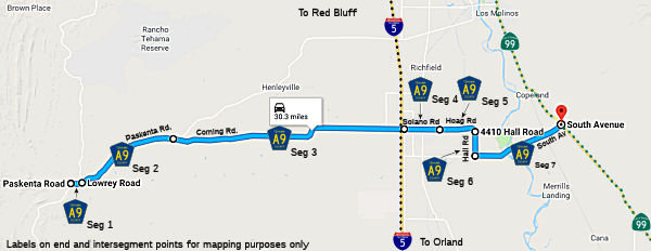 Paskenta Road in Paskenta from Round Valley Road to Lowery Road (0.65 mi)
Paskenta Road from Lowery Road to Corning Road (FAS, 5.50 mi).
Corning Road from Paskenta Road to Solano Street at the Corning City Limits (FAS, 13.17 mi).
Solano Street at the Corning City Limits to Hoag Road (FAS, 2.00 mi)
Hoag Road from Solano Street to Hall Road (FAS, 2.02 mi)
Hall Road from Hoag Road to South Avenue (FAS, 1.75 mi)
South Avenue from Hall Road to Route 99 S of Corning (FAS, 5.18 mi)
 History and Signage Information
This route was defined in 1967.
 Status
In April 2025, it was reported that work has begun on a modernization of
the intersection of Route 99 and County Sign Route A9, in Tehama County. The purpose of
this project is to reduce the frequency and severity of collisions. The
project includes replacing the existing stop sign controlled intersection
with a roundabout. Work will include roadway excavation to accommodate the
new alignment and structural section, installation of concrete curbs and
gutters, installation of a center island, installation of new signs, and
drainage improvements. Work will begin April 28, 2025 and includes five
phases of construction. The project is expected to end in November of 2025
(Source: District 2 on FB, 4/28/2025)
Total mileage: 30.27 mi.
© 1996-2024 Daniel P. Faigin.
Maintained by: Daniel P. Faigin
<webmaster@cahighways.org>.

 CR A8
CR A8 CR A10