
 California Highways:
Click here for a key to the symbols used. An explanation of acronyms may be found at the bottom of the page.
 Routing
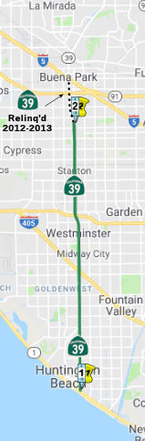 (a) Route 1 near Huntington Beach to the southern city limit
of Buena Park.
(a) Route 1 near Huntington Beach to the southern city limit
of Buena Park.
The relinquished former portions of Route 39 within the city limits of Azusa, Buena Park, Covina, and West Covina are not state highways and are not eligible for adoption under Section 81. For the relinquished former portions of Route 39, the Cities of Azusa, Buena Park, Covina, and West Covina shall maintain within their respective jurisdictions signs directing motorists to the continuation of Route 39.
 Post 1964 Signage History
▸As defined in 1963, Route 39 had a single segment: "Route 1 near Huntington Beach to Route 2 passing through or near Buena Park and via San Gabriel Canyon."
In 1958, route location studies were begun for a Route 39 freeway between Pacific Coast Highway and the Foothill Freeway in the general vicinity of existing Beach Blvd. There were public hearings in 1964 on the portion between Route 1 and Route 22. Studies on the northern portion were "later". A 1965 Planning Map shows Route 39 as the "Huntington Beach Freeway" through Orange County. The route would have paralleled old Route 39, Azusa Ave., in the SGV, continuing south along Beach Blvd. to the coast.
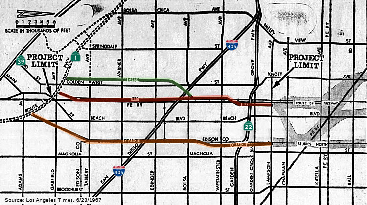 In 1967, proposals were presented for the Huntington
Beach Freeway routings for Route 39 between the Coast Freeway (Route 1) to
N of the Garden Grove Freeway (Route 22). The three proposed routings that
parallel Beach Blvd vary from 6.4 to 7.4 mi, and make up the southern
portion of the eventual full freeway that will run to I-210. Studies were
underway for the portion from Lampson Avenue to Route 60, with completion
expected in 1968. There was a lot of contention between the cities along
the route about which was the preferred route.
In 1967, proposals were presented for the Huntington
Beach Freeway routings for Route 39 between the Coast Freeway (Route 1) to
N of the Garden Grove Freeway (Route 22). The three proposed routings that
parallel Beach Blvd vary from 6.4 to 7.4 mi, and make up the southern
portion of the eventual full freeway that will run to I-210. Studies were
underway for the portion from Lampson Avenue to Route 60, with completion
expected in 1968. There was a lot of contention between the cities along
the route about which was the preferred route.
(Source: Los Angeles Times, 6/23/1967 via Joel Windmiller,
2/19/2023)
▸In 1978, Chapter 1043 divided the route into the current three segments: "(a) Route 1 near Huntington Beach to Route 72 in La Habra via Beach Boulevard. (b) Beach Boulevard to Harbor Boulevard in La Habra via Route 72. (c) Route 72 in La Habra to Route 2 via Harbor Boulevard to the vicinity of Fullerton Road, then to Azusa Avenue, Azusa Avenue to San Gabriel Canyon Road, San Gabriel Avenue southbound between Azusa Avenue and San Gabriel Canyon Road, and San Gabriel Canyon Road. "
▸In 2011, Chapter 536 (AB 957, 10/7/2011) permitted the relinquishment of the portion within the city limits of Buena Park from the Anaheim/Buena Park city limits to the junction with Route 5 (post mile 12.9 to post mile 15.1), on terms and conditions that the commission finds to be within the best interests of the state, effective upon the recordation of a certified copy hereof with the Recorder of Orange County. This segment was approved for relinquishment by the CTC in March 2012, and the resolution was recorded on April 9, 2012.
▸In 2013, SB 788 (Chapter 525, 10/9/13) split this into two segments and consolidated the relinquishment language:
(a) From Route 1 near Huntington Beach to the southern city limit of Buena Park.
(b) Route 5 in Buena Park to Route 72 in La Habra via Beach Boulevard.
The CTC is permitted to relinquish to the City of Buena Park the portion of Route 39 within the city limits of Buena Park from the Anaheim/Buena Park city limits to the junction with Route 5 (post mile 12.9 to post mile 15.1), on terms and conditions that the commission finds to be within the best interests of the state, if the department and the city enter into an agreement providing for that relinquishment. The following conditions shall apply upon relinquishment: (1) The relinquishment shall become effective on the date following the county recorder's recordation of the relinquishment resolution containing the commission's approval of the terms and conditions of the relinquishment. (2) On and after the effective date of the relinquishment, the portion of Route 39 relinquished under this subdivision shall cease to be a state highway and shall be ineligible for future adoption under Section 81. (3) For the portion of Route 39 relinquished under this subdivision, the City of Buena Park shall maintain within its jurisdiction signs directing motorists to the continuation of Route 39.The relinquished former portions of Route 39 within the city limits of Azusa, Buena Park, Covina, and West Covina are not state highways and are not eligible for adoption under Section 81. For the relinquished former portions of Route 39, the Cities of Azusa, Buena Park, Covina, and West Covina shall maintain within their respective jurisdictions signs directing motorists to the continuation of Route 39.
The portion of the route in Buena Park was relinquished in 2012. The portion of the route in Anaheim was relinquished in 2024. See STATUS below for details.
 Pre 1964 Signage History
In 1934, Route 39 was signed along the route from Jct. Route 3 (US 101A, later Route 1) near Huntington Beach to Jct. Route 2 near Valyermo, via Covina. This segment had two LRNs:
This segment from pre-1964 Route 26 south to the Pacific Coast Highway went under several different names in 1961 (all of these are now part of an extended Beach Boulevard): Huntington Beach Boulevard, Stanton Avenue (through the town of Stanton near Ball Road), Grand Avenue through Buena Park, and then Beach Boulevard in Mirada Hills. Near Westminster, this may have run along Coast.
As noted above, the definition of Route 39 incorporated LRN 171. This
took it past Knott's Berry Farm via Grand Avenue. The notoriety of Knott's
Berry Farm being located on early Route 39/Grand Avenue resulted in an
influx of business. Not only did this bring heavy traffic to Route 39/LRN 171 on Grand Avenue, Grand Avenue presented an issue for Route 39
southbound traffic given it had to briefly multiplex Route 18/LRN 178 on
Lincoln Avenue before continuing towards Route 3/LRN 60 via what was
Stanton Avenue. During late 1940 and early 1941, Knott's Berry Farm
constructed the Main Street of the Ghost Town amusement park. By 1942,
Route 39/LRN 171 was realigned off of Grand Avenue on a bypass of Knott's
Berry Farm via an extension of Stanton Avenue. Stanton Avenue would later
be renamed as Beach Blvd, for continuity of naming.
(Source: Gribblenation Blog (Tom Fearer), "Former California State Route 39 through Knott's Berry Farm via Grand Avenue", 2/2/2022)
 Status
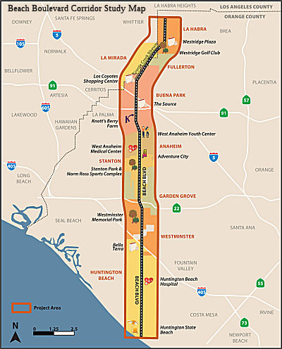 Beach Boulevard Corridor Study
In May 2019, OCTA announced surveys and scoping
meetings on how to improve Beach Blvd in Orange County. They noted: "This
major north-south thoroughfare crosses all the county’s major
freeways – Route 91, I-5, Route 22, I-405 – on its way from La
Habra to Huntington Beach, passing through the cities of La Mirada,
Fullerton, Buena Park, Garden Grove, Anaheim, Stanton, and Westminster.
It’s packed with retailers and businesses and entertainment centers
such as Knott’s Berry Farm. If you could improve Beach Boulevard,
what would you do? Would you make it easier for pedestrians and cyclists
to travel the road? Add more transit? Synchronize the lights for less
stop, more go?" The webpage on the study notes: "The Beach Boulevard
Corridor Study of the 21-mile-long stretch of Route 39 (Beach Boulevard)
is assessing existing conditions, forecasting projections of future
growth, and developing solutions ranging from enhanced pedestrian,
bicycle, and transit facilities to improved signal synchronization. Once
complete, OCTA and Caltrans will provide local agencies along Beach
Boulevard with improvement alternatives that will guide and enhance local
planning initiatives. The initiatives will support the future development
and formation of a collaborative and seamless transportation corridor from
the coast to Whittier Boulevard."
(Source: OCTA Blog, 5/9/2019; CorridorStudy
Webpage)
In May 2020, OCTA released the results of the Beach
Blvd Corridor Study. Those responding covered a lot of areas, but primary
desires appeared to be (1) increased coordination of traffic signals; (2)
more pedestrian bridges (presumably to improve pedestrian safety and
reduce slowdowns due to pedestrian crossing stops); (3) more bike lanes on
parallel streets; and high capacity transit along the corridor.
(Source: OCTA Blog 5/7/2020; Study Phase 2 Infographic)
Anaheim Relinquishment (12-Ora-39 11.6/12.9)
In August 2022, the CTC amended the following into the
SHOPP: 12-Ora-39 11.6/12.9. PPNO 12-3202A; ProjID 1218000089; EA 0R400.
Route 39 In Anaheim, from south of Ball Road to Stanton Avenue.
Financial Contribution Only (FCO) to the city of Anaheim to relinquish
roadway. Allocation ($ × 1,000): PA&ED $450; PS&E $0; R/W Sup
$226; Con Sup $0; R/W Cap $0; Const Cap: $4,813; Total $5,489. Concurrent
COS allocation under Resolution FP-22-11; August 2022.
(Source: August 2022 CTC Agenda, Agenda Item
2.1a.(1a) #25)
In August 2022, the CTC approved the following
pre-construction phase allocation: $450,000. 12-Ora-39 11.6/12.9. PPNO
12-3202A; ProjID 1218000089; EA 0R400. Route 39 In Anaheim, from south of
Ball Road to Stanton Avenue. Financial Contribution Only (FCO) to the city
of Anaheim to relinquish roadway. Allocation: FY24-25 PA&ED $450,000.
Concurrent Amendment under SHOPP Amendment 22H-003; August 2022.
(Source: August 2022 CTC Agenda, Agenda Item 2.5b.(2a) #26)
In May 2023, the CTC approved the following SHOPP (2a)
and SB1 (2b) allocation for preconstruction project phases for
environmental, design and R/W support: $226,000. 12-Ora-39 11.6/12.9. PPNO
12-3202A; ProjID 1218000089; EA 0R400. Route 39 In Anaheim, from south of
Ball Road to Stanton Avenue. Financial Contribution Only (FCO) to the city
of Anaheim to relinquish roadway. R/W Sup $226,000.
(Source: May 2023 CTC Agenda, Agenda Item 2.5b.(2a) #12)
In October 2024, the CTC authorized the requishment of
right of way in the city of Anaheim along Route 39 within the city limits
(1 segment, 12-Ora-39-PM 11.6/12.9), under the terms and conditions as
stated in the Relinquishment Agreement dated July 18, 2024. This
relinquishment is authorized by Chapter 423, Statutes of 2017, which
amended Section 339 of the Streets and Highways Code.
(Source: October 2024 CTC Agenda, Agenda Item 2.3)
Buena Park Relinquishment (~ ORA 12.656 to ORA 15.109)
In March 2012, the CTC authorized relinquishment of right of way in the city of Buena Park on Route 39 from the south city limits to Route 5 (~ ORA 12.656 to ORA 15.109), under terms and conditions as stated in the relinquishment agreement dated February 27, 2012, determined to be in the best interest of the State. Authorized by Chapter 536, Statutes of 2011, which amended Section 339 of the Streets and Highways Code.
The City of Buena Park has a number of plans for its portion of Route 39 after relinquishment to the city. These plans include landscaping and water fountains in the highway's median, and pedestrian walkways and bridges crisscrossing the roadway. It will also give businesses and the city more control of signage and rights-of-way.
 Naming
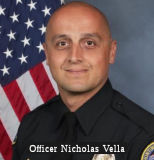 The portion of Route 39
between the junction with Route 1 (ORA 0.000), and Talbert Avenue (ORA
3.611) in the City of Huntington Beach is named the “Officer
Nicholas Vella Memorial Highway”. It was named in memory of
Officer Nicholas Vella, a 14-year veteran of the Huntington Beach Police
Department, who was killed in the line of duty at 44 years of age on
February 19, 2022. Throughout his tenure with the Huntington Beach Police
Department, Officer Nicholas Vella exemplified the true character of the
brave individuals who devote their time and energy to the perilous duties
of law enforcement, and he was renowned among his fellow officers for
loving, honoring, and being dedicated to his family, the uniform, and the
law enforcement community, all of which were indelible and inseparable in
his life. Named by Assembly Resolution ACR 162, Res. Chapter 135, 08/19/22.
The portion of Route 39
between the junction with Route 1 (ORA 0.000), and Talbert Avenue (ORA
3.611) in the City of Huntington Beach is named the “Officer
Nicholas Vella Memorial Highway”. It was named in memory of
Officer Nicholas Vella, a 14-year veteran of the Huntington Beach Police
Department, who was killed in the line of duty at 44 years of age on
February 19, 2022. Throughout his tenure with the Huntington Beach Police
Department, Officer Nicholas Vella exemplified the true character of the
brave individuals who devote their time and energy to the perilous duties
of law enforcement, and he was renowned among his fellow officers for
loving, honoring, and being dedicated to his family, the uniform, and the
law enforcement community, all of which were indelible and inseparable in
his life. Named by Assembly Resolution ACR 162, Res. Chapter 135, 08/19/22.
(Image source: Los Angeles Airport Police Officers Association)
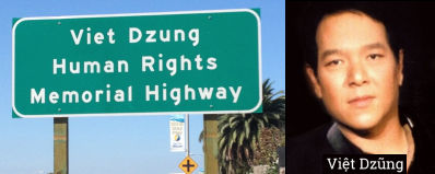 The portion of Route 39
(Beach Boulevard) between Talbert Avenue and I-405 in the County of Orange
(~ ORA 3.606 to ORA 5.861) is named the "Viet Dzung Human Rights
Memorial Highway". It was named in memory of Viet Dzung. Prior to
his death in December 2013, at the age of 55 years, Viet Dzung was a
recognized musician, songwriter, emcee, community leader, and an ardent
voice for freedom, human rights, and democracy, particularly in Vietnam.
Viet Dzung was born in Saigon, Vietnam, in 1958, to a former member of
parliament and a school teacher. After the end of the Vietnam War, he fled
to Singapore before moving to the United States in 1976 and being reunited
with his family. Drawing strength from his family’s refugee
experience, Viet Dzung was a champion involved in and leading the
Vietnamese American community to honor the Vietnamese culture and to
celebrate, defend, and press for freedoms both here and in Vietnam. Viet
Dzung was instrumental as an organizer and emcee for the annual Black
April Commemoration at the Vietnam War Memorial in the City of Westminster
to honor United States and South Vietnamese veterans and the soldiers who
sacrificed their lives for freedom during the Vietnam War. Viet Dzung
reached out to and involved thousands of Vietnamese Americans, including
performers, singers, students, business owners, religious leaders, and
nonprofit leaders, as a daily voice on Radio Bolsa every morning providing
news and public service announcements to the largest Vietnamese American
community in the United States. Viet Dzung, whose real name was Nguyen
Ngoc Hung Dung, was respected in Little Saigon and worldwide for his
dedication to the Vietnamese refugee community and his commitment to
fighting for human rights, religious freedom, and democracy in Vietnam.
Thousands of people have been inspired by Viet Dzung’s activism,
music, and art throughout his meaningful life. Viet Dzung’s life
serves as an example of how one person can have a positive impact on those
in his or her community. Named by Senate Concurrent Resolution 85,
Resolution Chapter 90, on July 9, 2014.
The portion of Route 39
(Beach Boulevard) between Talbert Avenue and I-405 in the County of Orange
(~ ORA 3.606 to ORA 5.861) is named the "Viet Dzung Human Rights
Memorial Highway". It was named in memory of Viet Dzung. Prior to
his death in December 2013, at the age of 55 years, Viet Dzung was a
recognized musician, songwriter, emcee, community leader, and an ardent
voice for freedom, human rights, and democracy, particularly in Vietnam.
Viet Dzung was born in Saigon, Vietnam, in 1958, to a former member of
parliament and a school teacher. After the end of the Vietnam War, he fled
to Singapore before moving to the United States in 1976 and being reunited
with his family. Drawing strength from his family’s refugee
experience, Viet Dzung was a champion involved in and leading the
Vietnamese American community to honor the Vietnamese culture and to
celebrate, defend, and press for freedoms both here and in Vietnam. Viet
Dzung was instrumental as an organizer and emcee for the annual Black
April Commemoration at the Vietnam War Memorial in the City of Westminster
to honor United States and South Vietnamese veterans and the soldiers who
sacrificed their lives for freedom during the Vietnam War. Viet Dzung
reached out to and involved thousands of Vietnamese Americans, including
performers, singers, students, business owners, religious leaders, and
nonprofit leaders, as a daily voice on Radio Bolsa every morning providing
news and public service announcements to the largest Vietnamese American
community in the United States. Viet Dzung, whose real name was Nguyen
Ngoc Hung Dung, was respected in Little Saigon and worldwide for his
dedication to the Vietnamese refugee community and his commitment to
fighting for human rights, religious freedom, and democracy in Vietnam.
Thousands of people have been inspired by Viet Dzung’s activism,
music, and art throughout his meaningful life. Viet Dzung’s life
serves as an example of how one person can have a positive impact on those
in his or her community. Named by Senate Concurrent Resolution 85,
Resolution Chapter 90, on July 9, 2014.
(Image sources: Wikimedia, Freedom for Vietnam Blog)
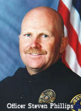 The portion of Route 39 (Beach Boulevard) between I-405 and Route 22 within
the boundaries of the City of Westminster (~ ORA 5.861 to ORA 8.425) is
named the "Westminster Police Officer Steven L. Phillips Memorial
Highway" This segment was named in memory of Westminster Police
Officer Steven L. Phillips, who died in an on-duty traffic accident on
January 29, 2004, at the intersection of Trask Avenue and Jackson Street
in the City of Westminster. Officer Phillips was the first officer in the
Westminster Police Department's 46-year history to die in the line of
duty. He was born on June 5, 1957, in Los Angeles, California. Officer
Phillips graduated from Edgewood High School in the City of West Covina
and joined the United States Air Force in 1976. He completed four years of
service as a military police officer, and continued his service with the
Air Force as a reserve military police officer assigned to the 30th
Security Forces Squadron at Vandenberg Air Force Base in Lompoc,
California. He was called back to active duty for a year after the World
Trade Center attacks on September 11, 2001, and served his time at
Vandenberg AFB. In 1986, Officer Phillips entered the Rio Hondo Police
Academy. The City of Westminster then hired Officer Phillips as a police
officer. Officer Phillips served in the Westminster Police Department for
18 years and he was a motor officer since 1991. He was an experienced
motor officer and he was responsible for training new motor officers.
Named by Assembly Concurrent Resolution (ACR) 70, Resolution Chapter 132,
on 9/19/2005.
The portion of Route 39 (Beach Boulevard) between I-405 and Route 22 within
the boundaries of the City of Westminster (~ ORA 5.861 to ORA 8.425) is
named the "Westminster Police Officer Steven L. Phillips Memorial
Highway" This segment was named in memory of Westminster Police
Officer Steven L. Phillips, who died in an on-duty traffic accident on
January 29, 2004, at the intersection of Trask Avenue and Jackson Street
in the City of Westminster. Officer Phillips was the first officer in the
Westminster Police Department's 46-year history to die in the line of
duty. He was born on June 5, 1957, in Los Angeles, California. Officer
Phillips graduated from Edgewood High School in the City of West Covina
and joined the United States Air Force in 1976. He completed four years of
service as a military police officer, and continued his service with the
Air Force as a reserve military police officer assigned to the 30th
Security Forces Squadron at Vandenberg Air Force Base in Lompoc,
California. He was called back to active duty for a year after the World
Trade Center attacks on September 11, 2001, and served his time at
Vandenberg AFB. In 1986, Officer Phillips entered the Rio Hondo Police
Academy. The City of Westminster then hired Officer Phillips as a police
officer. Officer Phillips served in the Westminster Police Department for
18 years and he was a motor officer since 1991. He was an experienced
motor officer and he was responsible for training new motor officers.
Named by Assembly Concurrent Resolution (ACR) 70, Resolution Chapter 132,
on 9/19/2005.
(Image source: OC Register)
 Named Structures
The interchange at I-405 and Route 39 in the County of Orange at Beach Boulevard (~ ORA 5.854) is named the ““Surf City USA” Interchange”. In 1991, the City of Huntington Beach adopted the nickname “Surf City USA” to recognize the city’s surf and beach culture, because Huntington Beach’s unique location offers consistent waves year round. The City of Huntington Beach is home to over 100 years of surfing history and 10 miles of coastline, including popular surfing spots such as the Huntington Beach Pier, HB Cliffs, Bolsa Chica State Beach, and Huntington State Beach; this makes surfing is a major part of the City of Huntington Beach’s culture and economy. The City of Huntington Beach’s surf culture is mentioned in popular songs such as “Surf City” by Jan and Dean, and the City of Huntington Beach is the home of the US Open of Surfing, the Huntington Beach International Surfing Museum, the Surfers’ Hall of Fame, and the Surfing Walk of Fame. Named by Assembly Concurrent Resolution (ACR) 87, Res. Chapter 57, Statutes of 2024 on 04/30/24.
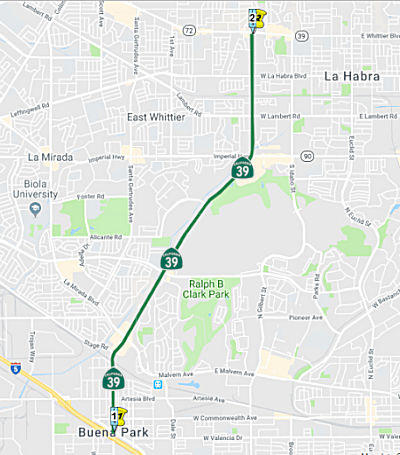 (b) Route 5 in Buena Park to Route 72 in La Habra via Beach Boulevard.
Post 1964 Signage HistorySee segment (a).
StatusIn February 2010, the CTC approved relinquishment of right of way in the city of La Habra along Route 39 on Imperial Highway between Brass Lantern Drive and Route 39 (~ ORA 19.12), consisting of a collateral facility.
Naming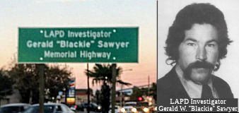 The portion of Route 39 (Beach Blvd.) in the City of Buena Park*
from Stage Road to Hillsborough Drive (~ ORA 16.123 to LA D18.319) to is
named the Gerald “Blackie” Sawyer Memorial Highway.
It was named after Detective Gerald “Blackie” Wayne Sawyer.
Sawyer was born in1941. In 1958, Detective Sawyer graduated from Excelsior
High School in the City of Norwalk, California, where he was a very active
student and played football. In 1963 Detective Sawyer began attending the
Los Angeles Police Academy, where he attained his ultimate desire by
becoming a proud member of the Los Angeles Police Department where he
served for 10 years. In 1971, Detective Sawyer relocated to the City of La
Mirada. On Tuesday, November 6, 1973, Detective Gerald Sawyer was shot and
killed while working in a joint undercover investigation with the United
States Drug Enforcement Administration. Detective Sawyer was shot by a
cocaine trafficker during an attempted robbery of a $144,000 flashroll.
The trafficker and an accomplice were arrested at the scene by other
narcotics detectives and charged with first degree murder. In 1974,
Detective Sawyer was awarded the Medal of Valor, the highest award given
an officer, for his ultimate sacrifice. In the years following Detective
Sawyer’s tragic death, countless police officers and detectives
nationwide have been made safer because of the training film outlining his
death. Named by Assembly Concurrent Resolution 16, Resolution Chapter 68,
August 8, 2013.
The portion of Route 39 (Beach Blvd.) in the City of Buena Park*
from Stage Road to Hillsborough Drive (~ ORA 16.123 to LA D18.319) to is
named the Gerald “Blackie” Sawyer Memorial Highway.
It was named after Detective Gerald “Blackie” Wayne Sawyer.
Sawyer was born in1941. In 1958, Detective Sawyer graduated from Excelsior
High School in the City of Norwalk, California, where he was a very active
student and played football. In 1963 Detective Sawyer began attending the
Los Angeles Police Academy, where he attained his ultimate desire by
becoming a proud member of the Los Angeles Police Department where he
served for 10 years. In 1971, Detective Sawyer relocated to the City of La
Mirada. On Tuesday, November 6, 1973, Detective Gerald Sawyer was shot and
killed while working in a joint undercover investigation with the United
States Drug Enforcement Administration. Detective Sawyer was shot by a
cocaine trafficker during an attempted robbery of a $144,000 flashroll.
The trafficker and an accomplice were arrested at the scene by other
narcotics detectives and charged with first degree murder. In 1974,
Detective Sawyer was awarded the Medal of Valor, the highest award given
an officer, for his ultimate sacrifice. In the years following Detective
Sawyer’s tragic death, countless police officers and detectives
nationwide have been made safer because of the training film outlining his
death. Named by Assembly Concurrent Resolution 16, Resolution Chapter 68,
August 8, 2013.
[*: Actually, it's not in the city of Buena
Park]
(Image Source: Blackie Sawyer Memorial Facebook Page)
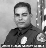 The portion of Route 39 on
Beach Boulevard in the City of La Habra from the south city limits to
Whittier Boulevard (~ ORA 18.49 to ORA 20.674) is named the "La Habra
Police Officer Michael Anthony Osornio Memorial Highway". It was
named in memory of Officer Michael Anthony Osornio, who was born in 1968,
in the City of Fayetteville, North Carolina, the youngest of four
children, to Rafael and Guadalupe Osornio. In 1976, his family moved to
the City of La Puente, California, and in 1979, moved to the City of
Walnut where Officer Osornio attended Suzanne Middle School and Walnut
High School, where he was a very active student and played football.
Officer Osornio relocated to the City of Montclair, where he resided with
his family. Officer Osornio attended law enforcement classes at Golden
West College, where he received his Police Officer Standards and Training
Certificate in November 1991. In September 1993, Officer Osornio obtained
his ultimate desire by becoming a proud member of the La Habra Police
Department, where he served for 13 months. On October 31, 1994, Officer
Osornio was patrolling the southwest portion of the city during the
graveyard shift and was stopped at a red traffic signal at westbound La
Habra Boulevard at Beach Boulevard. He began to accelerate when the
westbound traffic signal changed to green, when his patrol car was hit by
a vehicle as Officer Osornio crossed through the intersection, and he died
in the line of duty from injuries sustained in the collision. The driver
of that vehicle was driving at approximately 60 miles per hour and was
subsequently convicted of a felony for driving under the influence of
alcohol. In 2000, the La Habra Police Department created the Michael
Osornio Drunk Driving Apprehension Award in honor of Officer Osornio, and
that award is given to the police officer who makes the most arrests for
driving under the influence. Named by Senate Concurrent Resolution 78,
Resolution Chapter 88, on August 24, 2012.
The portion of Route 39 on
Beach Boulevard in the City of La Habra from the south city limits to
Whittier Boulevard (~ ORA 18.49 to ORA 20.674) is named the "La Habra
Police Officer Michael Anthony Osornio Memorial Highway". It was
named in memory of Officer Michael Anthony Osornio, who was born in 1968,
in the City of Fayetteville, North Carolina, the youngest of four
children, to Rafael and Guadalupe Osornio. In 1976, his family moved to
the City of La Puente, California, and in 1979, moved to the City of
Walnut where Officer Osornio attended Suzanne Middle School and Walnut
High School, where he was a very active student and played football.
Officer Osornio relocated to the City of Montclair, where he resided with
his family. Officer Osornio attended law enforcement classes at Golden
West College, where he received his Police Officer Standards and Training
Certificate in November 1991. In September 1993, Officer Osornio obtained
his ultimate desire by becoming a proud member of the La Habra Police
Department, where he served for 13 months. On October 31, 1994, Officer
Osornio was patrolling the southwest portion of the city during the
graveyard shift and was stopped at a red traffic signal at westbound La
Habra Boulevard at Beach Boulevard. He began to accelerate when the
westbound traffic signal changed to green, when his patrol car was hit by
a vehicle as Officer Osornio crossed through the intersection, and he died
in the line of duty from injuries sustained in the collision. The driver
of that vehicle was driving at approximately 60 miles per hour and was
subsequently convicted of a felony for driving under the influence of
alcohol. In 2000, the La Habra Police Department created the Michael
Osornio Drunk Driving Apprehension Award in honor of Officer Osornio, and
that award is given to the police officer who makes the most arrests for
driving under the influence. Named by Senate Concurrent Resolution 78,
Resolution Chapter 88, on August 24, 2012.
(Image source: Behind the Badge)
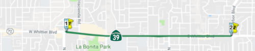 (c) From Beach Boulevard to Harbor Boulevard in La Habra via Whittier
Boulevard.
(c) From Beach Boulevard to Harbor Boulevard in La Habra via Whittier
Boulevard.
Post 1964 Signage HistoryThis segment was created by the original division of the route into segments in 1978 as "Beach Boulevard to Harbor Boulevard in La Habra via Route 72.". In 1981, the reference to Route 72 was changed to "Whittier", as the Route 72 segment was formally transfered to Route 39. This segment exists to connect the original Route 39 to the S with a planned freeway (never built) Route 39 betewen La Habra and West Covina.
Pre 1964 Signage HistoryThis segment was not part of the original Route 39; it was part of Route 72. Route 72 originally continued E from Beach Blvd and went S on Harbor. See Route 72 and Route 5 for additional details. This was part of LRN 2.
Sign Route 39 appeared to follow LRN 62, which had a routing (before 1935, and between 1945 and 1949) along Hacienda Blvd and Glendora Avenue to Garvey. LRN 62 was discontinuous at Garvey, pickup up at Azusa to continue N along Azusa Ave. Garvey (LRN 26) later became the San Bernardino Freeway.
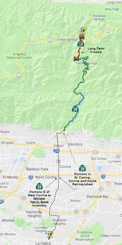 (d) Whittier Boulevard in La Habra to Route 2 via Harbor Boulevard to the
vicinity of Fullerton Road, then to Azusa Avenue, Azusa Avenue to San
Gabriel Canyon Road, San Gabriel Avenue southbound between Azusa Avenue
and San Gabriel Canyon Road, and San Gabriel Canyon Road, other than the
portion of the segment described by this subdivision that is within the
city limits of Azusa, Covina, and West Covina.
(d) Whittier Boulevard in La Habra to Route 2 via Harbor Boulevard to the
vicinity of Fullerton Road, then to Azusa Avenue, Azusa Avenue to San
Gabriel Canyon Road, San Gabriel Avenue southbound between Azusa Avenue
and San Gabriel Canyon Road, and San Gabriel Canyon Road, other than the
portion of the segment described by this subdivision that is within the
city limits of Azusa, Covina, and West Covina.
The relinquished former portions of Route 39 within the city limits of Azusa, Buena Park, Covina, and West Covina are not state highways and are not eligible for adoption under Section 81. For the relinquished former portions of Route 39, the Cities of Azusa, Buena Park, Covina, and West Covina shall maintain within their respective jurisdictions signs directing motorists to the continuation of Route 39.
Post 1964 Signage HistoryThis segment was created by the original division of the route into segments in 1978 as "Route 72 in La Habra to Route 2 via Harbor Boulevard to the vicinity of Fullerton Road, then to Azusa Avenue, Azusa Avenue to San Gabriel Canyon Road, San Gabriel Avenue southbound between Azusa Avenue and San Gabriel Canyon Road, and San Gabriel Canyon Road."
In 2000, the portion within the City of Azusa S of Post Mile 17 was reliquished to the containing city [SHC 339(c)]. Additionally, the portion of Route 39 that is within the City of Covina was been relinquished to that city when appropriate terms have been accepted by that city. (SHC 339(d), added by Assembly Bill 2909, Enrolled August 28, 2000. In 2003, Assembly Bill 1717 (Chaptered 9/25/2003, Resolution Chapter 525) changed the legislative definition to exclude the relinquished portions in Azusa and Covina.
In 2004, SB 1578 authorized the relinquishment of the portion in West Covina as well.
In December 2011, the CTC authorized relinquishment of right of way in the city of Azusa on Route 39 from Arrow Highway to 330 feet north thereof, under terms and conditions as stated in the relinquishment agreement dated November 7, 2011, determined to be in the best interest of the State. Authorized by Chapter 264, Statutes of 1996, which amended Section 339 of the Streets and Highways Code.
SB 1578, chaptered September 9, 2004, authorizes the California Transportation Commission to relinquish to the City of West Covina any portion of Route 39 that is located within the city limits of West Covina, pursuant to the terms of a cooperative agreement between the city and the department, upon a determination by the commission that the relinquishment is in the best interests of the state. Said relinquishment becomes effective immediately following the recordation by the county recorder of the relinquishment resolution containing the commission's approval of the terms and conditions of the relinquishment. At that point, the portion of Route 39 relinquished ceases to be a state highway, and cannot be considered for future readoption. Furthermore, the City of West Covina is required to maintain within its jurisdiction signs directing motorists to the continuation of Route 39. In September 2005, the CTC considered this relinquishment.
In 2010, SB 1318 (9/29/10, Chapter 421) made the following change:
"...within the city limits of Azusa, and Covina, and West
Covina."
In 2013, SB 788 (Chapter 525, 10/9/13) added back the language regarding West Covina.
Pre 1964 Signage HistoryIn 1934, Route 39 was signed along the route from Jct. Route 3 (US 101A, later Route 1) near Huntington Beach to Jct. Route 2 near Valyermo, via Covina. This route consisted of the following:
According to Scott Parker (Sparker) at AAroads:
The non-state-highway gap in Route 39 was actually signed from about 1958 to the mid-70's -- with older porcelain-white button-copy 1955-type shields -- in fact signage indicating route continuity was at least as complete, if not more so, than other urban state highways in District 7. Los Angeles County maintained the signage, with at least the tacit complicity of the Division of Highways, who likely supplied the shields themselves. North to south, the route was signed from the I-10/Azusa Ave. interchange, using South Garvey Avenue (the south I-10 frontage road) west from Azusa immediately south of the interchange. It was signed west right along the frontage road to Hacienda Blvd., where it turned southwest. It continued on Hacienda Blvd. south through West Covina, La Puente, and Hacienda Heights before going over the top of the Puente Hills. The Hacienda Blvd./quasi-Route 39 alignment continued to Whittier Blvd., where it turned west to Beach Blvd. The full signage of this section lasted until the 1964 renumbering, when state highway shields were changed to white-on-green.
After 1964, the county apparently lost interest in signage of this route; the black-on-white shields disappeared along the South Garvey frontage road, and were seen only sporadically along Hacienda. Curiously, when the Route 60/Pomona Freeway was completed through Hacienda Heights in late 1967, the Hacienda Blvd. exit signage showed that street as Route 39. When Route 72 was signed on Whittier Blvd and Harbor Blvd. in La Habra in 1968, the junction with Hacienda Blvd. clearly indicated that route as Route 39, complete with new green shields. However, Hacienda Blvd. itself remained sporadically signed, even immediately north and south of the Route 60 freeway. After 1964, there was no signage on southbound Route 39 to indicate that it continued south of I-10; northbound, the signage simply "petered out" north of Francisquito Avenue in West Covina. The expansion of the Westfield West Covina mall in the 1970's, which included a reconfiguration of Hacienda Blvd. that moved the main flow of traffic to Vincent Ave. west of the mall and the downgrading of Hacienda Ave. from Vincent north to South Garvey to more or less an access road to the east side of the mall essentially put a nail in the Route 39 signage "coffin". By 1982, a "TO" banner was placed on the Route 60 BGS reference to Route 39; a few years later, the shield was greened out completely.
In the early 2000's there was one "straggler" green Route 39 shield on NB Hacienda north of Anza; it was gone by 2010. With the north end of Hacienda Blvd. essentially a mall access road, and South Garvey having been truncated when the I-10/Azusa Ave. interchange was reworked in the '80's, there is no current physical continuity along the original L.A. County-signed route. Hacienda Blvd. through the Puente Hills remains a twisting, curvy 2-lane road -- albeit well-delineated with Caltrans-type outer lane striping.
Both the Harbor Blvd./Azusa Ave. corridor from east La Habra north to Covina -- the route described in the Route 39 legislative description -- and Colima Ave (Los Angeles County Sign Route N8) crossing the hills to the west are multilane boulevards, but they certainly don't look like Caltrans-spec facilities (short left-turn pockets, curbs rather than shoulders), rather typical arterials through the housing tracts that line the Puente Hills. It appears that, despite the state legislative description, none of the relevant jurisdictions have any interest in signing and maintaining any surface connection between northern Orange County and the east San Gabriel Valley.
(Ref: Sparker @ AARoads, 9/15/2016)
As for San Gabriel Canyon Road: In 1914, Azusa officials posted a sign at the entrance to San Gabriel Canyon calling on the state to build a road into the steep mountains, saying it would be “the most scenic mountain road in So. California.” Completed in 1961, San Gabriel Canyon Road, later designated Route 39, took drivers through towering gorges, dark canyons and above raging rivers, connecting with Angeles Crest Highway, later designated Route 2, at a remote spot 8,250 feet in elevation called Islip Saddle. The ride was not only scenic but for the first time connected San Gabriel Valley residents directly to Wrightwood and local ski areas. The route, however, was closed regularly due to landslides. One such rock slide during the winter of 1978 grabbed a large portion of the highway, sending pavement, culverts and drain pipes tumbling into the valley below, forcing cars to U-turn just north of Crystal Lake and cutting off easy access to ski resorts and notable natural areas, such as Mount Williamson, Jackson Lake and the Pacific Crest Trail. Caltrans considered the segment to be closed permanently in 1978, with Mother Nature declared the victor. However.... according to a planning report on a CalTrans site, this might actually be reopened:
"LA-39-40.0/44.4 19920K Reopen Highway (PC/AG) This project is currently in PSR review stage with changes still being made by Project Studies. This Office submitted amendments to the PEAR on September 7, 2000 for Alternative 5 and the cost estimate for biological mitigation (including Alternative 5). According to the 2nd draft of the PSR the recommended environmental document likely is an EIR/EIS for Alternative 5 (the preferred alternative)."
In October 2017, it was reported that a member of Congress and a Los
Angeles County supervisor took directors from the Azusa Chamber of
Commerce and representatives of Caltrans on a helicopter tour of the
4.4-mile gap with the goal of reopening the closed portion of Route 39 all
the way to Route 2 for public access. After in October 2016 that Caltrans
would fill in the gap, nothing has happened. The department is in the
midst of a preliminary engineering study to assess what kind of
environmental studies are needed and how much construction will cost,
Lauren Wonder, Caltrans spokeswoman, said. The study will be completed in
Spring 2018. It was noted that the road needs to be restored to two lanes
each way so that people escaping a fire can go north or south to exit the
forest. During past fires in the Angeles National Forest or its foothills,
the only way out was south to Azsua, she said. Sometimes helicopters had
to evacuate survivors. Recently, minimal repairs made to the closed
roadway allows emergency vehicles, such as fire trucks, access to the
southeastern Angeles from Route 2 and from Crystal Lake north to Route 2,
connecting to Mount Wilson, La Cañada Flintridge and Pasadena via the
I-210, or Inland Empire cities via I-15.
(Source: SGV Tribune, 10/15/2017)
The City of Industry has a document that describes the origins of FAS Rte 1274, which appears to be today's Route 39 and County Sign Route N8. This was to be a route from Huntington Beach and north across the San Gabriel Mountains to the Antelope Valley. The project involved the extension of Azusa Avenue through West Covina to link with Pass and Covina Road just S of Amar Road in La Puente. Part of this effort involved remaking Grazide Road into a four-lane divided highway from Hacienda Bl east for ½ mi.
StatusLa Habra to the Angeles National Forest
 Between La Habra and Route 10 in Azusa, this was a planned
freeway routing that was never built. It is unclear if Route 39 is signed
between Whitter Blvd / Harbor Blvd and I-10; if it is, the signed Route 39
between those points is the pre-1964 routing. According to the Traversable
Routing report, between the Orange County line (Whittier Blvd) and Route 10, the traversable local roads are Harbor Blvd, Fullerton Road, Colima
Road, and Azuza Ave. Right of way engineering was recommending deletion of
this portion from the state system.
Between La Habra and Route 10 in Azusa, this was a planned
freeway routing that was never built. It is unclear if Route 39 is signed
between Whitter Blvd / Harbor Blvd and I-10; if it is, the signed Route 39
between those points is the pre-1964 routing. According to the Traversable
Routing report, between the Orange County line (Whittier Blvd) and Route 10, the traversable local roads are Harbor Blvd, Fullerton Road, Colima
Road, and Azuza Ave. Right of way engineering was recommending deletion of
this portion from the state system.
The 2013 Traversable Highways report notes that presently this is designated as LA County Sign Route N8. It has been District 07's intent to relinquish the majority of Route 39, as it primarily serves local traffic.
Currently, the routing is as follows: When entering the southern city-limits, it follows Beach Blvd. Afterwards, it shortly jogs east on Whittier Blvd. State maintenance ends at Harbor Blvd.. Note that, historically, Route 39 continued north of La Habra city-limits, via Hacienda Blvd.
The SAFETEA-LU act, enacted in August 2005 as the reauthorization of TEA-21, provided the following expenditures on or near this route:
In Decmeber 2011, the CTC approved $900K to construct three maintenance vehicle pullouts, one retaining wall, 20 freeway access gates, in Monrovia, Duarte, and Azusa, at various locations from Huntington Drive to Azusa Avenue (Route 39).
Angeles National Forest to Crystal Lake
In April 2016, an update on Route 39 was reported. An El Niño storm
wiped out Route 39 north of East Fork Road (~ LA 25.718) on Jan. 6, 2016.
The road to the alpine ecosystem was damaged and had to be closed.
Likewise, the connection to Wrightwood on Route 2 — also knows as
the Angeles Crest Highway — from I-210 in La Cañada Flintridge
had been closed at Islip Saddle, a plateau that sits at the intersection
of Route 2 and Route 39, where 7 miles of Route 39 has been closed from
Route 2 going on 40 years. April saw Caltrans reporting the repair of the
damaged portion of Route 39 and its reopening to the Crystal Lake
Recreation Area from Azusa. At the same time, Caltrans re-opened Route 2
from Islip Saddle to 5 miles west of Big Pines.
(Source: SGV Tribune, 4/29/2016)
In September 2009, the CTC approved for future consideration of funding this project, which was described as a project in Los Angeles County that will rehabilitate, re-open, and construct roadway improvements on Route 39 within the Angeles National Forest north of the city of Duarte. It was noted that the project is fully funded. The project is programmed in the 2008 State Highway Operation and Protection Program for $47,592,000, capital and support. Construction is estimated to begin in Fiscal Year 2011-12.
North Fork San Gabriel Bridge (LA R31.2)
![[Pier Repair]](https://www.cahighways.org/maps/039-pier.jpg) In February 2010, the CTC
approved a project in Los Angeles County to rehabilitate an existing pier
on the North Fork San Gabriel Bridge on Route 39 in the Angeles National
Forest (LA R31.2). The project is fully funded in the 2008 State Highway
Operation and Protection Program. The total estimated project cost is
$3,874,000 for capital and support. Construction is estimated to begin in
Fiscal Year 2011-12. A Mitigated Negative Declaration (MND) has been
completed.
In February 2010, the CTC
approved a project in Los Angeles County to rehabilitate an existing pier
on the North Fork San Gabriel Bridge on Route 39 in the Angeles National
Forest (LA R31.2). The project is fully funded in the 2008 State Highway
Operation and Protection Program. The total estimated project cost is
$3,874,000 for capital and support. Construction is estimated to begin in
Fiscal Year 2011-12. A Mitigated Negative Declaration (MND) has been
completed.
In June 2019, the CTC made the following construction
allocation: $18,239,000 07-Los Angeles-39 R31.2 ProjID 0718000018. Route 39 Near Azusa, at the North Fork San Gabriel River Bridge No. 53-2245.
Replace bridge with a new single-span structure on an alignment to the
south, install guardrail, and construct a Maintenance Vehicle Pullout
(MVP). Const. $13,763,000 Const Engr. $4,476,000 (Future consideration of
funding approved under Resolution E-10-09; February 2010.)
(Source: June 2019 CTC Minutes, Agenda Item
2.5b.(1) Item 23)
March 2026 review of the DRAFT 2026 SHOPP identified
the following new project: 07-LA-39 R31.25. PPNO 07-6226; ProjID
0724000020; EA 39710. Route 39 In Los Angeles County, at North Fork San
Gabriel River Bridge № 53-2245. Replace bridge and realign roadway.
(Long Lead Project). Note: The bridge is located within the Angeles
National Forest and will require coordination with the U.S. Forest Service
and multiple resource agencies. The project involves extensive
environmental studies and permitting, including 404, 401, 402, and 1602
permits. Additional time is needed for environmental document preparation
and bridge design development. Allocation ($ × 1,000): PA&ED
$2,366; ⊘PS&E $4,193; ⊘R/W Sup $94; ⊘Con
Sup $7,148; ⊘R/W Cap $371; ⊘Const Cap $32,097; TOTAL $46,269.
Begin Const: 5/1/2031. “⊘”
indicates phase not authorized.
(Source: Caltrans SHOPP Page: DRAFT 2026 SHOPP PROPOSED, State Highway Operation and Protection Program, Fiscal Years 2026-27 through 2029-30
(PDF), January 31, 2026; March 2026 CTC Agenda, Agenda Item 4.7)
In June 2026, the CTC approved the following allocation
for SHOPP SB1 preconstruction project phases (environmental support):
$2,366,000. 07-LA-39 R31.25. PPNO 07-6226; ProjID 0724000020; EA 39710.
Route 39 In Los Angeles County, at North Fork San Gabriel River Bridge
№ 53-2245. Replace bridge and realign roadway. (Long Lead Project).
Note: The bridge is located within the Angeles National Forest and will
require coordination with the U.S. Forest Service and multiple resource
agencies. The project involves extensive environmental studies and
permitting, including 404, 401, 402, and 1602 permits. Additional time is
needed for environmental document preparation and bridge design
development. Pre-Construction Phase Allocation ($ × $1000): Budgeted
(Actual, if different): PA&ED $2,366.
(Source: June 2026 CTC Agenda, Agenda Item 2.5b.(5) #8)
Crystal Lake Road to Route 2
The portion between Crystal Lake Road and Route 2 (~ LA 38.148 to LA
44.383) is currently closed. However, according to a report on 12/15/02 in
the Whittier Daily News, it may be reopened in the future. According to
the article, by January 2003, Caltrans officials expect to have a plan in
place to repair Route 39 where it meets Angeles Crest Highway. This 6.2
mile stretch was closed after a major storm in 1978, mainly due to
erosion, frequent landslides, and forces of nature. The primary reason for
the road closure was due to sections of the highway eroding, especially at
the Snow Spring Slide. A primary reason for the highway eroding was due to
water collecting on the roadway because culvert inlets overflow and this
water consequently causes the highway to erode. A secondary cause was
recurring geological activities, such as landslides, sever winter storms,
and floods. The route provides a recreational loop from Azusa to La Canada
Flintridge, with an option to veer toward Wrightwood. However, it may take
until 2007 to open the road. Without the route, residents must drive an
extra 45 miles through the forest to get to Route 2 in La Canada
Flintridge, or to I-15 in Rancho Cucamonga to reach higher-elevation
campgrounds, ski areas and restaurants in Wrightwood. There are two
phases:
(Thanks to Greg Saia for providing this
information, including forwarding information he obtained from
Caltrans.)
![[Route 39]](https://www.cahighways.org/maps/039-002.jpg) In the 1990s and early 2000s, the highway was kept open by
Caltrans maintenance personnel for forest and emergency access. The
roadway was most degraded at the drainages, which had reached their
holding capacity, causing the road to flood, triggering sections of the
highway to erode. The area had large rock chutes, combined with huge
amounts of snow pack runoff, making the location prone to rock slides and
other geological activities. In 1990, a service road for maintenance
vehicles was opened to provide emergency access to Route 2. This required
blasting large rocks that had fallen from the cliffs onto the road. All
drains were cleaned, berms built to channel runoff, and cracks sealed to
protect the roadway from additional damage. This level of maintenance
repairs, which began in Fall 1990, continued each succeeding year until
potential sensitive biological resources were located at Snow Spring in
September 1994, at which time maintenance activities were halted. Since
1994, accumulated sediments and large boulders have saturated the
drainages, resulting in impeded water flow and sometimes flooding and
eroding the roadway. As of 2003, the conditions within the closed section
had degraded to such a level that a safety hazard to the maintenance crew
and the public had been created. It became necessary to clear those
drainages due to safety hazards present in the roadway, especially for the
public since it is utilized for hiking, biking, and other non-motorized
recreational activities.
In the 1990s and early 2000s, the highway was kept open by
Caltrans maintenance personnel for forest and emergency access. The
roadway was most degraded at the drainages, which had reached their
holding capacity, causing the road to flood, triggering sections of the
highway to erode. The area had large rock chutes, combined with huge
amounts of snow pack runoff, making the location prone to rock slides and
other geological activities. In 1990, a service road for maintenance
vehicles was opened to provide emergency access to Route 2. This required
blasting large rocks that had fallen from the cliffs onto the road. All
drains were cleaned, berms built to channel runoff, and cracks sealed to
protect the roadway from additional damage. This level of maintenance
repairs, which began in Fall 1990, continued each succeeding year until
potential sensitive biological resources were located at Snow Spring in
September 1994, at which time maintenance activities were halted. Since
1994, accumulated sediments and large boulders have saturated the
drainages, resulting in impeded water flow and sometimes flooding and
eroding the roadway. As of 2003, the conditions within the closed section
had degraded to such a level that a safety hazard to the maintenance crew
and the public had been created. It became necessary to clear those
drainages due to safety hazards present in the roadway, especially for the
public since it is utilized for hiking, biking, and other non-motorized
recreational activities.
(Source: January 2003 Initial Study/Environmental Assessment, State
Route 39 Roadway Rehabilitation Project, Draft EA/IS,
07-LA-39-133201)
According to the Caltrans EIR (PDF) dated January 2009, the project (which appears to be Phase II above) would rehabilitate and reopen a 4.4-mile segment of Route 39 from post miles 40.0 to 44.4, in the Angeles National Forest, in Los Angeles County. The restored connection would be accessible to public highway traffic throughout the year, with seasonal closures during times of inclement weather. These closures would likely occur during Winter and early spring. Phase I, mentioned above, rebuilt the roadway at Snow Spring, making it traversable throughout the length of the project area. Maintenance activities included the cleaning of drainage culverts and the erection of a dirt berm. With these past improvements, the roadway is passable, but only open to emergency service vehicles, and it is constricted as it approaches its northerly terminus at post mile 40.00.
The proposed project would consist of the following actions; the reconstruction of culverts and construction of new retaining walls, installation of new metal-beam guard rails and widening of the shoulder at the Route 39/Route 2 intersection, maintenance of drainage inlets at each end of the closed segment and at Snow Spring, and repaving of the roadway within project limits. The design alternatives being considered are:
In April 2009, it was noted that the project is fully funded. The project is programmed in the 2008 State Highway Operation and Protection Program for $43,360,000, capital and support. Construction is estimated to begin in Fiscal Year 2010-11.
In April 2011, it was reported that Caltrans opened Route 39 to allow motorists access to Crystal Lake Road on Tuesday, March 22 at 6:30 a.m. There is no access to Route 39 beyond Crystal Lake Road. The highway may be closed occasionally due to inclement weather. The project to repair storm damaged sections of Route 39 in the Angeles National Forest began May 2010. Two retaining walls were built to help support the highway. This $400,000 contract was awarded to Chumo Construction, Inc. of Baldwin Park, California.
In October 2011, it was reported that despite earlier promises, Caltrans is abandoning plans to reopen a 4.4-mile section of Route 39 in the Angeles National Forest between Crystal Lake and Wrightwood, citing rising costs, engineering challenges and a mandate to protect bighorn sheep offspring. Caltrans had agreed to repair the long-closed gap in Route 39 in May 2009. After stakeholders attended several scoping meetings in Azusa, the state agency said it would spend $32 million on new drainage, an 890-foot mechanical wall and a redirected portion of the highway at Snowy Springs, about 23 miles north of Azusa and less than a mile north of Crystal Lake. The last portion of Route 39 connecting it to Highway 2 was built in 1957 by order of President Dwight Eisenhower. It washed away in heavy rains in 1978, a result of what some call shoddy engineering. It has never re-opened. In a Caltrans letter dated Sept. 26, 2011, the agency said engineering and environmental mitigations would most likely increase the project's cost, making it no longer feasible. They wrote it was likely to be washed out again, making the repair project "less than a prudent investment." They also also wrote that the California Department of Fish and Game notified Caltrans of the protected status of the big horn sheep in the area, making the reopening of the road within their habitat "problematic." Caltrans cited the recent death of a neonatal bighorn lamb on the closed portion of the highway as evidence that a working road would increase the likelihood of lambs being run over. To prevent lamb deaths, the road would therefore have to be closed or restricted during the sheep's birthing season from January to June.
In January 2012, it was reported that Caltrans now wants to relinquish
the portion of Route 39 in the San Gabriel Mountains betwween Azuza and
Route 2 to either the U.S. Forest Service or Los Angeles County. L.A.
County needs the highway to access three dams critical to flood control.
The Forest Service's interest is access to Angeles National Forest by the
public and, at times, by firefighters. The agency spent $6 million
improving a spacious campground at Crystal Lake, where the highway now
ends after winding along the San Gabriel River past the Morris and San
Gabriel reservoirs. The problem is… neither agency wants the road.
Caltrans spends $1.5 million a year maintaining the two-lane paved
roadway, which is damaged regularly by landslides, flooding, falling rocks
and forest fires. Further, if Caltrans abandons the road (as opposed to
relinquishment), the Forest Service interpretation is that "…if
Caltrans abandons the highway, they have to remove their improvements
— meaning the road — and return the area to the natural
landscape." A landslide swept away the highest part of the road in 1978,
cutting it off from Angeles Crest Highway (Route 2). Since then, that last
stretch of asphalt has been roamed by Nelson's bighorn sheep, creatures
fully protected under state law. Caltrans concluded that it would be
cost-prohibitive to re-engineer that 4.4-mile gap and legally risky to try
because it cannot guarantee that the sheep would not be killed in the
process. As a result, the highway has become what Caltrans spokesman
Patrick Chandler described as "essentially a 27-mile-long cul-de-sac."
(Source: Los Angeles Times, 1/29/2012)
In February 2012, the San Gabriel Valley Council of Governments voted unanimously to oppose Caltrans' abandonment of 27 miles of Route 39 from Azusa to Crystal Lake. The agency also voted to write a letter requesting the state transportation agency continue the project it started in 2009 to repair a 4.4-mile gap in the the highway between Islip Saddle and Wrightwood at Angeles Crest Highway. That upper portion of Route 39 has been closed to the public since 1978 due to a mud slide that damaged the roadway.
In September 2016, a question to the Cajon Pass Commuter raised
the question of whether this stretch of Route 39 would be reopened. The
question was passed to Patrick Chandler, public information officer with
Caltrans District 7, who said: "There are no projects to reconnect [Route 39] to [Route 2]. There was several years ago, but that's not going to
happen. There is no funding for it. And it's way more than just
landslides. It's way more than that."
(Source: Victor Valley Daily Press, 9/2/2016)
In October 2016, it was reported that, just maybe, work might proceed on
reopening Route 39. A 1978 mud-and-rock slide took out a 4.4-mile chunk of
the mountain highway about 27 miles north of Azusa, leaving a gap between
Route 39 and Route 2, better known as Angeles Crest Highway. For decades,
civic and business leaders called for repairing the broken portion of the
state highway bisecting a majestic set of canyons, peaks and rivers
enjoyed by more people than any other national forest. And in 2009 the
state had answered in the affirmative. But in 2011, just days before
construction was to begin, Caltrans announced it abandoned the fix.
Instead, the $32 million set aside for Route 39 went toward repairing a
bridge on Route 1 in Northern California. Now, five years after the
stinging reversal, the cities of Azusa and Glendora, business groups, a
local congresswoman and the San Gabriel Valley Council of Governments have
convinced Caltrans to consider reopening the road to Route 2. Caltrans has
indicated that they are preparing the engineering design and environmental
studies in support of this effort. One sticking point is the presence of
the San Gabriel Mountains bighorn sheep known as Nelson’s bighorn
sheep, ovis canadensis nelsoni. In 2011, Caltrans said it was
unwilling to rebuild the road because motorists may run into or over the
state protected species, particularly the lambs. Caltrans and the state
Department of Fish and Wildlife are tussling over the issue. Caltrans
would not agree to build the road without another study that shows the
sheep’s location. Previous studies showed the sheep, which numbered
292 in 2006, were mostly at Cucamonga Peak, Mount Baldy, Iron Mountain and
Twin Peaks, far from Islip Saddle/Snow Canyon. The San Gabriel Valley
Council of Governments, a collaboration of 31 cities, three county
supervisors and three water agencies, has written a letter to the U.S.
Forest Service, asking to include a completed Route 39 as part of its
management plan for the forest and the 346,177-acre San Gabriel Mountains
National Monument. The letter, from council Executive Director Philip
Hawkey, says the entire route was included in a 1919 state bond measure.
The letter states completion of the 4.4-mile damaged portion would provide
better access for recreation, fire suppression and search and rescue
teams. Fires and floods can leave people in Mountain Cove, an Azusa
mountain neighborhood, and various mountain camps and campgrounds trapped
in the San Gabriel Mountains with no way out. Providing a northerly escape
route through Route 39 to Route 2 would save lives and also provide
quicker fire suppression responses.
(Source: SGV Tribune, 10/17/2016)
The 2020 SHOPP, approved in May 2020, included the NEW Long Lead
Roadway Protective Betterment program item of interest: 07-Los
Angeles-39 PM 40.0/44.4 PPNO 5381 Proj ID 0718000117 EA 34770. Route 39
near Falling Springs, from 1.8 miles north of Crystal Lake Road to Route 2. Rehabilitate and reopen a 4.4 mile segment of Route 39. Note: Complex
environmental issues due to the protected species, Nelson’s Bighorn
Sheep. This leads to risks to cost and schedule, as well as
constructability concerns. Programmed in FY26-27, with construction
scheduled to start in May 2027. Total estd. project cost is $57,100K, with
$35,100K being capital (const and right of way) and $22,000K being support
(engineering, environmental, etc.). Only the PA&ED Phase is programmed
in the 2020 SHOPP for $7,900K.
(Source: 2020 Approved SHOPP a/o May 2020)
In December 2022, it was reported that Caltrans is considering repairing
a 4.4-mile closed gap in Route 39 in the northern section of the Angeles
National Forest, a washed-out portion of highway north of Azusa, closed
for 44 years, that blocks local access to ski areas and high-desert
communities. A scoping meeting was held in mid December 2022, with
officials from Caltrans leading a presentation on roadway fixes as well as
key environmental issues, which will include a discussion about protecting
the Nelson’s bighorn sheep, a state-listed endangered species.
Completed in 1957, the dead-end road leaves motorists so close — yet
so far — from higher elevations, picturesque vistas of pines, and
snow country. If the road was repaired, closer access to the quaint
mountain village of Wrightwood would be restored. The road was washed out
in 1978 by severe mud and rock slides. Caltrans has restored a
rudimentary, one-lane shoulder only for emergency vehicles, such as Los
Angeles County Sheriff’s Department, and various fire agencies that
fight forest fires in the rugged national forest. A fully restored state
highway for long-awaited public access, connecting I-210 with Route 2, is
one option of six on the table. Other options include: keeping it as a
emergency route but closed to the public; building only a road for visitor
shuttles and bicycles; constructing an elevated viaduct adjacent to the
existing highway; or building just a single travel lane for vehicles,
meaning cars would have to pull over for oncoming traffic to pass. If
restored for public access, residents of high desert communities such as
Victorville — even Lancaster and Palmdale — could enjoy the
mountains and then have dinner in Azusa, Duarte or Glendora.
(Source: Daily News, 12/10/2022)
In January 2023, it was reported that a primary obstacle to repair of
Route 39 may be a skittish population of protected sheep known for their
crowns of curled horns—Nelson’s Bighorn Sheep, Ovis
canadensis nelsoni. About 417 bighorns are estimated to be living
in the highest slopes of these rugged mountains within the Angeles and San
Bernardino national forests. Because these mountain sheep are
protected, any sheep that is injured or dies as a result of construction,
or operation, of the restored highway would violate state law. Caltrans
may not want to take that risk. More than 10 years ago, Caltrans built a
narrow shoulder on the washed out part of Route 39 to connect to Route 2
for use by emergency vehicles. It has been used to rescue and evacuate
people from several fires. It has also been used to maneuver firetrucks
for fire suppression. The shoulder is not open to the public and signs are
posted to keep out. But the sheep use it. Video camera footage show the
bighorn in the slopes near the gap, at Islip Saddle and Snow Springs. A
family of 12 live and breed within a mile of the gap. They stand around in
the middle of the pavement, feed there, drink there. They even lamb there.
During a scoping meeting on Dec. 15, 2022, Caltrans laid out several
alternative project designs, including full restoration of the public
highway. About 250 people attended. Some objected to restoring the road,
saying more cars would bring traffic and air pollution into the small town
of Wrightwood. Some said they didn’t want to see bighorn sheep
carcasses on the road. Many spoke in favor of opening a two-lane road
through to Route 2, as it was before the long ago rock slide. Some favored
a project that would allow pedestrians and bicyclists, plus a shuttle for
passengers driven by a trained operator — but not a public road.
(Source: San Gabriel Valley Tribune, 1/2/2023)
In October 2023, the CTC revised the following long-lead project in the
2022 SHOPP: 07-LA-39 40/44.4. PPNO 07-5381; ProjID 0718000117; EA 34770.
Route 39 Near Falling Springs, from 1.8 miles north of Crystal Lake Road
to Route 2. Rehabilitate and reopen a 4.4 mile segment of Route 39. Note:
Completion of PA&ED is being delayed by difficulties surveying the
terrain due to slides and storm damage, additional alternatives being
considered, additional time needed for environmental reviews, additional
permitting needs, and additional required studies. Delay all other
phases to allow for more time to complete PA&ED. No changes to
allocation, but change FY to FY29-30.
(Source: October 2023 CTC Agenda, Agenda Item 2.1a.(1e) #1)
In April 2024, it was reported that Caltrans was holding public hearings
on reopening this segment. Azusa foresees an economic benefit. With the
highway repaired, one could drive from La Canada Flintridge east on Route 2, then go south on Route 39 and end up in Azusa. The views on Route 39,
sometimes called The Forgotten Highway, are spectacular and the city hopes
first-timers would take a drive on the scenic highway, then check in at a
restaurant or shop at its Target store. Reaching the Mountain High ski
resorts via Azusa could add economic opportunity in the town. San Gabriel
Valley dwellers wouldn't face a two-hour drive via I-210, I-15 and Route 138. Instead, they would take Route 39, then travel east on Route 2, for a
trip of about 40 minutes. One of the main benefits of the reopening cited
by Caltrans is safety. Although a tight shoulder was carved out in 2003
for emergency vehicles, rock slides have blocked access and are damaging
the shoulder. Caltrans reports that a fully restored highway would
"provide enhanced access for the Los Angeles County Sheriff's Department
and other emergency personnel during search and rescue activities." The
EIR also states that a restored roadway and connection to Route 2 would
reduce response times. The closed section continues to suffer rock slides
and degradation. A repair project would include installing hillside
netting to capture falling rocks as well as roadway retaining walls. New
culverts would drain stormwater. The road has received new guardrails but
infrastructure would need to be maintained. Aside from rock slides, snow,
and costs ranging upward of $57 million, a skittish hoofed mammal lives in
the Angeles National Forest in small numbers and under state protected
status, including in the Islip Saddle region where the road has been
closed to vehicles for nearly five decades. The Nelson's Bighorn Sheep,
Ovis canadensis nelsoni, the rarest hoofed mammals on the continent, are
known for their curled horns and elusive behavior. They live in select
forest regions: Iron Mountain area, near the East Fork of the San Gabriel
River, in and around Middle Fork and South Fork of Lytle Creek in the San
Bernardino National Forest, and near Mt. San Antonio (Mt. Baldy). But the
sub-group closest to the project come from the Twin Peaks area, five miles
west of Route 39, researchers say. Although the gates keep cars out, the
sheep like the closed-off area very much, especially the ewes who have
been spotted there with their baby lambs on the closed road section, said
Dustin Pearce, environmental scientist with the California Department of
Fish and Wildlife.
(Source: MSN, 4/12/2024)
In June 2025, the CTC revised this project in the 2024 SHOPP: 07-LA-39
40.0/44.4. PPNO 07-5381; ProjID 0718000117; EA 34770. Route 39 Near
Falling Springs, from 1.8 miles north of Crystal Lake Road to Route 2.
Rehabilitate and reopen a 4.4 mile segment of Route 39 as an
evacuation route. (Long Lead Project) (PA&ED,
PS&E, R/W Sup only). FY Changes: 29-30 28-29.
Allocation Changes ($ × $1000) [“⊘”
indicates phase not programmed]: PS&E $7,000 $8,632;
R/W Sup $100 $178; ⊘Con
Sup $7,000 $13,201; ⊘R/W
Cap $100 $3; ⊘Const
Cap $35,000 $51,582; TOTAL $57,100 $81,496.
Note: Program PS&E and R/W support phases on this long lead project
because the environmental document has been completed. Advance the year of
delivery to expedite the reopening of the route so that it can be used as
an evacuation route in case emergencies such as wildfires. Update project
description to match the preferred alternative. Increase in cost is based
on the estimate for the preferred alternative.
(Source: June 2025 CTC Agenda, Agenda Item 2.1a.(1d) #58)
In October 2025, the CTC approved for future consideration of funding
07-LA-39, PM 40.0/44.4. California State Route 39 (San Gabriel Canyon
Road) Reopening Project. Restore and reopen a segment of Route 39
as an evacuation route and for use by the Department, United States Forest
Service, and emergency-response personnel. (FEIR) (PPNO 5381) (SHOPP) The
project includes roadway rehabilitation, roadway delineation, clearing of
debris and rocks, drainage system restoration, new retaining walls, repair
of existing soldier pile walls, and repair of masonry retaining walls.
Resources that require mitigation to reduce impacts to less than
significant levels include biological resources (specifically, sensitive
species and state or federally protected wetlands). Mitigation measures
include replanting of native species, installation of silt fencing and
berms, speed control measures to reduce the potential for wildlife
collisions, pre-construction wildlife surveys and relocation, biological
monitoring and habitat enhancements during construction, fund
contributions to the U.S. Forest Service (should Bighorn Sheep vehicle
collisions occur) to improve habitat quality and Bighorn Sheep population
monitoring, invasive species control measures, preparation of a mitigation
and monitoring plan for planting, and purchase of similar habitat in the
region for areas that would be permanently impacted. The major concern is
Nelson’s Bighorn Sheep, which are is present in the project area and
could be impacted either directly through human/vehicle-induced mortality
or changes in movement patterns, or indirectly through loss of habitat.
Any loss of an individual Bighorn Sheep before the goals described in its
recovery plan are met should be considered a potentially significant
impact. Any loss of habitat within the project area should be considered a
loss of Bighorn Sheep habitat and would also be a potentially significant
impact. The statement of facts notes that, included as part of the
proposed project design, the speed limit would be reduced to 30 miles per
hour along the straight portions of the highway to further reduce the
potential for wildlife collisions. Signage indicating wildlife crossings
would also be installed to remind drivers of the potential hazard.
Caltrans would also contribute funds to the U.S. Forest Service (USFS) for
the implementation of the strategic plan to improve habitat quality and
Bighorn Sheep population monitoring in the vicinity of the proposed
project site. The EIR notes that "The geology and slope instability
continue to degrade current conditions, producing flooding of the roadway,
landslides, erosion, and falling rocks. Portions of the existing
4.4-mile-long “gap” face slope erosion/failures due to storm
events, causing retaining wall and roadway failure. Several landslides
have occurred within the project limits, and various locations along the
project are susceptible to frequent rockfall. Existing stormwater inlets
are buried by the rockfall, further causing roadway and slope erosion to
occur. Further deterioration of the existing roadway and walls is expected
if they are not properly repaired or rehabilitated. Cumulatively, these
problems cause a safety hazard for maintenance workers and emergency
service personnel that use the route." The EIR identified six alternatives
that were considered; alternatives 5 and 6 were later eliminated as being
non-viable:
(Source: October 2025 CTC Agenda, Agenda Item 2.2c.(6), State Route 39 (SR-39/San Gabriel Canyon Road) Reopening Project Finale EIR, January 2025)
The EIR indicates that Alternative 2 was selected, and gives the
following reasons:
(Source: State Route 39 (SR-39/San Gabriel Canyon Road) Reopening Project Finale EIR, January 2025)
In October 2025, the CTC approved the following pre-construction phase
allocation for a 2024 SHOPP project: $8,810,000. 07-LA-39 40.00/44.40.
PPNO 07-5381; ProjID 0718000117; EA 34770. Route 39 Near Falling Springs,
from 1.8 miles north of Crystal Lake Road to Route 2. Rehabilitate
and reopen a 4.4 mile segment of Route 39 as an evacuation route.
(PA&ED, PS&E, R/W Sup only) Concurrent consideration of funding
under Resolution E-25-62; October 2025. As part of this allocation
request, the Department is requesting to extend the completion of PS&E
an additional 7 months beyond the 36 month deadline. Pre-Construction
Phase Allocation: Budgeted (Actual, if different):
PS&E $8,632,000; RW Sup $178,000.
(Source: October 2025 CTC Agenda, Agenda Item 2.5b.(2a) #14)
In May 2026, the CTC amended the following project into the 2026 SHOPP:
07-LA-39 40.8. PPNO 07-6485; ProjID 0726000179; EA 2XX60. Route 39 Near
Fallings Springs, from 3.6 miles south of Route 2. Reconstruct embankment
and repair roadway. Note: In December 2025, a series of winter storms
caused significant storm water runoff that resulted in erosion of
the berm and shoulder, as well as damage and collapse of the roadway. This
project will restore the embankments and repair the roadway. Allocation ($
× $1000): PA&ED $0; PS&E $0; R/W Sup $100; Con Sup $330; R/W
Cap $100; Const Cap $1,205; TOTAL $1,735.
(Source: May 2026 CTC Agenda, Agenda Item 2.1a.(1a) #39)
NamingThe proposed name for the freeway segment was the "Huntington Beach" Freeway. It was named for its terminus in Huntington Beach. Huntington Beach was named for Henry E. Huntington, nephew of Collis P. Huntington and a Southern California Utility magnate and promoter.
Post 1964 Signage HistoryPre-1978, this was a continuous route from Route 1 to Route 2. A 1965 planning map shows this as freeway from Route 1 to Route 210; never constructed/upgraded. Route/location studies were conducted in 1958, with public hearings in 1964.
If one hikes over the planned route, one will discover two "tunnels to nowhere" and one "bridge to nowhere". These are along the E fork of the San Gabriel River. One tunnel was built in 1961; the other was built in 1964. They were to be a part of Route 39 up the East Fork of the San Gabriel River to Vincent Gap (at Route 2). The road is called present-day Shoemaker Canyon Road and is only partially paved. The Bridge to Nowhere was part of a road up the East Fork of the San Gabriel River built in 1929 to 1938, when most of the road was destroyed by a rainstorm, leaving the bridge stranded. The Road to Nowhere was another attempt made from 1954 to 1969, stopped this time by budget-cutters and environmentalists
Pre 1964 Signage HistoryIn 1934, Route 39 was signed along the route from Jct. Route 3 (US 101A, later Route 1) near Huntington Beach to Jct. Route 2 near Valyermo, via Covina.
 Other WWW Links
 Statistics
Overall statistics for Route 39:
 Freeway
[SHC 253.3] From Route 5 to Route 210. Not upgraded. The portion between Route 1 and Route 210 was added to the Freeway and Expressway system in 1959; in 1988, the Freeway and Expressway designation was redefined to Route 5 to Route 210.
 Scenic Route
[SHC 263.4] From Route 210 near Azusa to Route 2.
Although this segment is eligible for Scenic Highway status, it has not yet met the criteria to be officially designated as Scenic Highway.
 Pre-1964 Legislative Route
The route that would become LRN 39 was first defined by Chapter 680 in 1915, which called for "a state highway from Tahoe City, Placer County, along the N boundary of Lake Tahoe to the W boundary of Nevada at Crystal Bay". This was captured substantially intact in the 1935 highway code as:
"Tahoe City along the northern boundary of Lake Tahoe to the Nevada State Line at Crystal Bay"
This definition remained unchanged until the 1963 renumbering. It was signed as Route 28, and started at Route 89.
© 1996-2024 Daniel P. Faigin.
Maintained by: Daniel P. Faigin
<webmaster@cahighways.org>.

 Route 38
 Route 40