
 California Highways:
Click here for a key to the symbols used. An explanation of acronyms may be found at the bottom of the page.
 Routing
 Post 1964 Signage History
In 1963, this route was defined as "Route 101 near Ford Road to Route 101 near Mountain View."
In 1968, Chapter 282 added the following, which did not change the definition of the route:
Mathilda Avenue, which is part of Route 85 in the City of Sunnyvale, is hereby declared to be a city street within the meaning of Sections 189 and 190, and is eligible for an allocation of funds for grade separation pursuant to Section 190.
The legislature finds and declares that although Mathilda Avenue is presently a portion of Route 85, the commission has approved an alternate routing, the department has commenced acquisition of the property necessary for right-of-way along the new route, and Mathilda Avenue will be returned to the City of Sunnyvale within a few years. Because of the heavy traffic congestion at the intersection of Mathilda Avenue and the Southern Pacific Company's railroad tracks, it is necessary that Mathilda Avenue be eligible for a grade separation allocation as soon as possible.
In 1988, Chapter 106 changed the origin to be "Route 101 near Bernal Road in San Jose"
As freeway, the first section of this route opened was from I-280 near
Cupertino to US 101 near Mountain View; it opened in 1965.
(Source: San Jose Mercury News, 12/7/15)
The Route 85 freeway was first planned in 1965, but there was no money to
complete the $785 million project until 1984 when Santa Clara County
became the first county in California to tax itself to build a state
project. The new freeway was completed in 1994. The Santa Clara County
Traffic Authority, which existed for 10 years while the tax was in place,
was created to team with Caltrans to oversee work. It was composed of
nearly two dozen local leaders, such as city council members, supervisors,
and public works officials. It approved cost-saving moves, such as
scrapping plans to build an expensive tunnel between Route 85 and I-280,
not building interchanges at Quito Road and Prospect Road, and building
half an interchange at Winchester Boulevard. It also approved a truck ban
and metering lights. Some extra costs were approved. Los Gatos and
Saratoga wanted to avoid excessive noise and insisted that the freeway be
built below grade at an eventual additional cost of $60 million. However,
the cost saving measures also lead to the original dirt center median
— a 46- to 50-foot-wide strip of dirt with no protective barrier
— that was within Caltrans regulations then that no guard rail was
required for a median of 45 feet or wider unless there was a high rate of
head-on collisions on that freeway. As the freeway did not exist, there
was no history of such collisions. However, within three years, seven
people were killed on Route 85 in median-related incidents, several by
drunk drivers who lost control and sped through the unprotected dirt
median, slamming head-on into opposing traffic. Those deaths lead Caltrans
to adopt a new policy that added median barriers to 400 miles of highways
throughout the state.
(Source: Mercury News, "The story of the Highway 85 decision that saved money and cost lives: Roadshow", 8/23/2020)
In 1992, a 4 lane, 2 mile section in San Jose from Santa Teresa Blvd east
to Cottle Road opened. In 1993, the route was extended a mile east (S) to
Great Oaks Blvd, and a mile west (N) to Almaden Expressway. The opening of
these sections coincided with the opening of Route 87 from Almaden
Expressway south to Route 85. The final sections from Almaden Expressway
to Route 280 and the short, ¾ mile gap between Great Oaks Blvd and US 101 opened Oct. 19, 1994.
(Source: SJMN, 12/7/15)
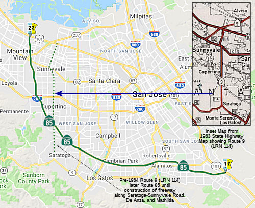
Originally, there was a traversable maintained routing from Route 9 to I-280 along De Anza Blvd and Saratoga-Sunnyvale Rd. It was immediately relinquished when the freeway was completed in 1994, although the state agreed to repave it before handing it over to the cities of Cupertino and Saratoga. This relinquishment was before the California Transportation Commission in July 2000. As of 2007, there were still a significant number of remaining postmiles, especially in Saratoga.
Prior to the 1994 opening of the Route 85 freeway, only the Cupertino
portion (between Homestead and Bollinger) of De Anza was signed as "De
Anza Boulevard". To the north, the road was known as Sunnyvale-Saratoga
Road and Saratoga-Sunnyvale Road to the south. The Route 85 exits were
originally signed as Saratoga-Sunnyvale Road but were changed to the
current "De Anza Boulevard" shortly after the freeway opened when the city
of San Jose agreed to change the name to De Anza Blvd so now within the
city limits of Cupertino and San Jose, the road is known as De Anza Blvd.
Saratoga's portion, starting at Prospect Road retains the old name,
Saratoga-Sunnyvale Road.
(Source: Myosh_Tino on AAroads, 6/20/2018)
 Pre 1964 Signage History
This route was only proposed in 1963; it was unsigned. It was the "under construction" routing for LRN 114, defined in 1959. The old surface routing was defined in 1933. The portion of the route between Saratoga and US 101 was part of the original signed Route 9 before 1964.
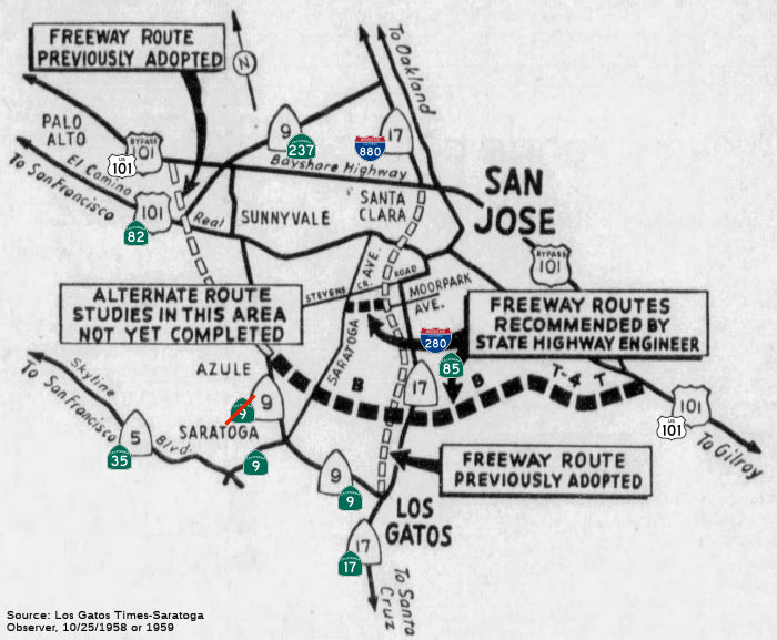 Around 1958, the CHC announced that it was considering adoption of routings for the
Serra Freeway near its southern terminus in San Jose. One section of
freeway extends from US 101 S of Ford Road in San Jose to Sign Route 9
(Saratoga-Sunnyvale Rd) S of Azule, a distance of 15.5 mi. From US 101 the
recommended route runs W across Cottle Road to the S and parallel with
Downer Ave to the vicinity of Snell Road where it swings N. It then runs N
of and roughly parallel with Downer Ave, Kooser Road, and Los
Gatos-Alamaden Road to Sign Route 17 (Route 17/I-880). It then continues W
to Sign Route 9 (Saratoga-Sunnyvale Rd), crossing Saratoga Ave about
midway between Campbell and Saratoga.
Around 1958, the CHC announced that it was considering adoption of routings for the
Serra Freeway near its southern terminus in San Jose. One section of
freeway extends from US 101 S of Ford Road in San Jose to Sign Route 9
(Saratoga-Sunnyvale Rd) S of Azule, a distance of 15.5 mi. From US 101 the
recommended route runs W across Cottle Road to the S and parallel with
Downer Ave to the vicinity of Snell Road where it swings N. It then runs N
of and roughly parallel with Downer Ave, Kooser Road, and Los
Gatos-Alamaden Road to Sign Route 17 (Route 17/I-880). It then continues W
to Sign Route 9 (Saratoga-Sunnyvale Rd), crossing Saratoga Ave about
midway between Campbell and Saratoga.
(Source: Los Gatos Times-Saratoga Observer, 10/25/1958 or 1959, via
Joel Windmiller, 2/23/2023)
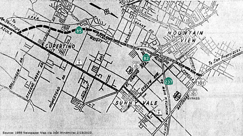 In 1956, public hearings were conducted for "Sign Route 9" (future Route 85)
between Azula (Saratoga-Sunnyvale Road) and the Bayshore Freeway. Azule is
located at the railroad crossing on Sign Route 9 between Saratoga and
Cupertino. The proposed freeway (which is hard to map to present routings
due to street changes and the orientation of the map) runs roughly along
the lines of Stevens Creek and westerly of the present highway, just N of
Moffett Field. As of 1956, Sign Route 9 (now Sunnyvale-Saratoga Road and
Matilda Ave, as the state signage for Sign Route 9 in this area was
dropped in the 1964 renumbering) met the Alviso-Mountain View Road (future
Route 237) just S of Moffett Field.
In 1956, public hearings were conducted for "Sign Route 9" (future Route 85)
between Azula (Saratoga-Sunnyvale Road) and the Bayshore Freeway. Azule is
located at the railroad crossing on Sign Route 9 between Saratoga and
Cupertino. The proposed freeway (which is hard to map to present routings
due to street changes and the orientation of the map) runs roughly along
the lines of Stevens Creek and westerly of the present highway, just N of
Moffett Field. As of 1956, Sign Route 9 (now Sunnyvale-Saratoga Road and
Matilda Ave, as the state signage for Sign Route 9 in this area was
dropped in the 1964 renumbering) met the Alviso-Mountain View Road (future
Route 237) just S of Moffett Field.
(Source: 1956 Newspaper Article via Joel Windmiller, 2/13/2023)
The tricky part is the portion between Route 17 and US 101 in San Jose. There is some evidence that the original definition of LRN 239 used what was Route 85 for a time. Nathan Edgars noted on some Wikipedia work pages that (note: I've changed Nathan's route notation to the notation used here):
The initial definition of [LRN 239] (mostly I-280) said "to [LRN 2] near San Jose". This is inconclusive, but other evidence shows that it used what is now [Route 85] southeast of [Route 17]: the 1959 law creating the F&E System included "[LRN 239] from [LRN 2] south of San Jose to [LRN 5]"; the rest was added by the clause including Interstates. The 1961 law creating [LRN 292] ([Route 87]) specified that it was to end at "[LRN 239] in the vicinity of Pearl Avenue". [LRN 239] was moved in 1961 to "the junction of [LRN 68] and [LRN 69]", and was removed from the F&E System descriptions, as that was part of I-680. At the same time, the F&E System description of [LRN 114] (and [LRN 114] itself) was extended to cover this. Presumably what is now I-880, and was then I-680, between I-280 and US 101 was [LRN 5] until 1961. This would have replaced the old surface routing, which was closer to current I-280 than I-880. [LRN 5] was moved to present I-280 between [Route 17] and US 101 in 1961, replacing part of [LRN 115] (which had been moved there in 1959).
Route 85 was not defined as part of the initial state signage of routes in 1934. It is unclear what (if any) route was signed as Route 85 between 1934 and 1964.
 Status
Silicon Valley Express Lanes
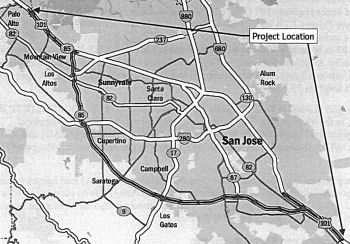 In November 2014, the VTA considered a plan to convert
the existing high-occupancy vehicle lanes on Route 85 from US 101 in South
San Jose to US 101 in Mountain View to allow single-occupancy vehicles to
pay a fee during rush hour to join carpool, clean-air vehicles,
motorcyclists and transit buses in the relatively faster lane. Route 85
currently has six lanes, including a carpool lane in each direction. If
the project is approved and implemented, single-occupant vehicles would be
able to begin using FasTrak, electronic technology that Bay Area motorists
are already using on local toll bridges. Motorists would find overhead
signs alerting drivers to the upcoming express lanes. Signs will also be
erected telling drivers the price to enter the approaching lane. The
express lanes' exit will be situated to give drivers adequate distance to
change lanes prior to reaching the interchange. A double white line would
be painted alongside the express lane to prevent drivers from moving in
and out of the lane and to prevent weaving issues. The full cost of the
project if it were to include the second-lane component is approximately
$170 million. During the meeting, however, the VTA voted to temporarily
suspend the project. Despite the recommendation of a VTA member of a
single-lane conversion, the board approved a motion by San Jose District
10 director Johnny Khamis to postpone the project and direct staff to
prepare a side-by-side comparison of the one lane versus two lanes plan
and conduct additional community outreach.
In November 2014, the VTA considered a plan to convert
the existing high-occupancy vehicle lanes on Route 85 from US 101 in South
San Jose to US 101 in Mountain View to allow single-occupancy vehicles to
pay a fee during rush hour to join carpool, clean-air vehicles,
motorcyclists and transit buses in the relatively faster lane. Route 85
currently has six lanes, including a carpool lane in each direction. If
the project is approved and implemented, single-occupant vehicles would be
able to begin using FasTrak, electronic technology that Bay Area motorists
are already using on local toll bridges. Motorists would find overhead
signs alerting drivers to the upcoming express lanes. Signs will also be
erected telling drivers the price to enter the approaching lane. The
express lanes' exit will be situated to give drivers adequate distance to
change lanes prior to reaching the interchange. A double white line would
be painted alongside the express lane to prevent drivers from moving in
and out of the lane and to prevent weaving issues. The full cost of the
project if it were to include the second-lane component is approximately
$170 million. During the meeting, however, the VTA voted to temporarily
suspend the project. Despite the recommendation of a VTA member of a
single-lane conversion, the board approved a motion by San Jose District
10 director Johnny Khamis to postpone the project and direct staff to
prepare a side-by-side comparison of the one lane versus two lanes plan
and conduct additional community outreach.
(Source: San Jose Mercury News, 10/30/2014, 11/13/2014)
In May 2015, it was reported that Los Gatos was joining
the suit over widening the freeway from Route 87 to I-280, using the
median for double carpool lanes. The plan is to convert the diamond lane
on the entire length of Route 85 into an express lane that solo drivers
can jump into for a toll. Light rail runs in the median on Route 87 from
Route 85 to downtown San Jose, and BART uses the median to run trains
along the center of I- 580 and eventually Route 4, but those plans were
hatched when those freeways were built. When Route 85 was designed, the
median from Route 87 to I-280 was reserved for mass transit, according to
agreements signed in 1989. That may be a pivotal issue in the lawsuit. It
was also noted that intersections were originally planned for Prospect and
Quito roads.
(Source: San Jose Mercury News, 5/19/2015)
In June 2015, it was reported that the Los Altos City
Council on June 9 supported establishing a working group to explore
options for the corridor (other than express lanes). According to the
current plan, solo drivers with FasTrak accounts would be able to pay a
toll and use the carpool lane on Route 85. The Santa Clara Valley
Transportation Authority project covers Route 85 from US 101 in Mountain
View to south San Jose. Caltrans, the highway’s owner and operator,
approved the project’s final environmental document and found no
significant impact. But Cupertino, Saratoga and Los Gatos recently filed
separate lawsuits against Caltrans and the VTA for “failing to
prepare an adequate environmental impact report” for the proposed
Route 85 project. Los Altos did not formally comment on the environmental
document at that time. The VTA is in the midst of implementing its Silicon
Valley Express Lanes Program, which includes the project on Route 85. The
project converts approximately 27 miles of existing carpool lanes to
express lanes, extending between US 101 in Mountain View and Bailey Avenue
on US 101 in south San Jose. The project also adds a second express lane
between Route 87 and I-280 in the median and converts the existing carpool
direct-connector in south San Jose to an express-lane connector. If the
project continues on schedule and with adequate funding, the VTA
anticipates opening the express lanes late 2018.
(Source: Los Altos Online, 6/24/2015)
In June 2015, the CTC approved for future consideration of funding a project in Santa Clara County that will convert High Occupancy Vehicle lanes on Route 85 to express lanes and add an express lane in each direction. The project is not fully funded. The project is programmed for the Project Approval and Environmental Document phase in the Santa Clara Valley Transportation Authority’s Federal Transportation Improvement Program with local and federal funds. The estimated cost is $170,000,000 for capital and support. Construction is estimated to begin in Fiscal Year 2018-19. (map above is from CTC proposal)
In August 2015, it was reported that there will be
eight northbound and nine southbound locations for the Route 85 express
lanes. Northbound, they'll be at US 101 in South San Jose, Cottle Road,
Almaden Expressway, Union Avenue, Winchester Boulevard, Saratoga-Sunnyvale
Road, Homestead Road and Middlefield Road. The nine southbound access
areas will be at US 101 in Mountain View, El Camino Real, Stevens Creek
Boulevard, Saratoga-Sunnyvale Road, Quito Road, Union Avenue, Camden
Avenue, Blossom Hill Road and Metcalf Road.
(Source: SJ Mercury News, 8/25/2015)
In June 2016, it was reported that a plan to construct
toll lanes in the median of Route 85 median could be abandoned, after city
leaders made clear that the undeveloped strip of land dividing the
congested highway ought to be reserved for transit rather than solo
drivers. In June 2016, the Santa Clara Valley Transportation Authority
(VTA) board of directors agreed to put a half-cent sales tax measure on
the November ballot. If passed, the tax would generate $6.5 billion over
30 years, and would help to pay for myriad transportation projects
throughout the region. The resolution to put the measure on the ballot,
which was approved on June 2, includes carving out $350 million in tax
revenue to go toward improving traffic flow along Route 85, one of the
county's most congested highways. However, the resolution explicitly calls
for a transit lane, as contrasted to a HOT lane. A project development
schedule for improvements on Route 85 show that the next two years will be
primarily dominated by a lengthy environmental clearance of the transit
lane project. Construction is expected to begin by the summer of 2020.
(Source: Mountain View Voice, 6/30/2016)
In November 2016, it was reported that the idea of
extending light rail along Route 85 may gain steam instead of adding a
second carpool lane between Route 87 and I-280. The 2016 Measure B sales
tax would earmark $350 million for the Route 85 corridor and a trolley
line on Route 85 could go as far north as US 101 in Mountain View.
(Source: Mercury News, 11/3/2016)
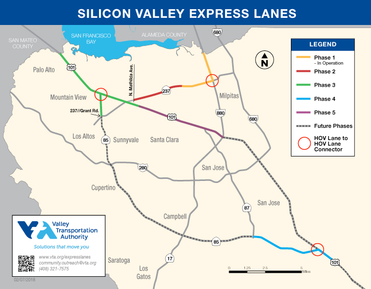 The 2018 STIP, approved at the CTC March 2018 meeting, also appears to create a number of PPNOs for this project. On Route 85, there is PPNO 2015F Route 85 Silicon Valley Express Lns Program-Ph4-Civil; and 2015G Route 85
Silicon Valley Express Lns Program-Ph4-ETS. According to the VTA page on the program, the Route 85 portion will convert approximately
24 miles of existing High Occupancy Vehicle (HOV or carpool) lanes to
express lanes and will add a second express lane between Route 87 and
I-280 in the median. The project will also convert the existing HOV direct
connector in south San Jose from US 101 to Route 85 to an express lane
connector. Based on the map from VTA (see above), Phase 4 runs from the
start of the route at US 101 to Route 87 (~ SCL 0.0 to SCL 5.193); it also
appears to include the portion on US 101 from 101 SCL R25.292 to SCL
R26.873.
The 2018 STIP, approved at the CTC March 2018 meeting, also appears to create a number of PPNOs for this project. On Route 85, there is PPNO 2015F Route 85 Silicon Valley Express Lns Program-Ph4-Civil; and 2015G Route 85
Silicon Valley Express Lns Program-Ph4-ETS. According to the VTA page on the program, the Route 85 portion will convert approximately
24 miles of existing High Occupancy Vehicle (HOV or carpool) lanes to
express lanes and will add a second express lane between Route 87 and
I-280 in the median. The project will also convert the existing HOV direct
connector in south San Jose from US 101 to Route 85 to an express lane
connector. Based on the map from VTA (see above), Phase 4 runs from the
start of the route at US 101 to Route 87 (~ SCL 0.0 to SCL 5.193); it also
appears to include the portion on US 101 from 101 SCL R25.292 to SCL
R26.873.
In May 2019, the CTC approved the following allocation
for a locally administered STIP project: $600,000 04-SCL-85 R0.0/R5.2.
Route 85 Silicon Valley Express Lanes Program - Phase 4 - Civil. Convert
existing carpool lanes to express lanes on Route 85 from US 101 south (in
San Jose) to Route 87, including the existing US 101/Route 85 HOV to HOV
direct connector ramps and the approaches to and from US 101. R/W funding.
PPNO 04-2015F. ProjID 0417000232. The CTC also approved the following
allocation: $8,600,000 04-SCL-85 0.0/5.2. Route 85 Silicon Valley Express
Lanes Program - Phase 4 ETS. Develop and install Electronic Tolling System
(ETS) on Route 85 from US 101 south (in San Jose) to Route 87, including
the existing US 101/Route 85 HOV to HOV direct connector ramps and the
approaches to/from US 101. PS&E funding. PPNO 04-2015G. ProjID
0417000232.
(Source: May 2019 CTC Minutes, Agenda Item 2.5c.(2)
Item 1; Agenda Item 2.5c.(5))
In December 2019, the CTC had the following allocation
on its agenda: 04-SCl-101 38.3/45.9. PPNO 2015J Proj ID 0417000233 EA
1K553. US 101 Silicon Valley Express Lanes Program - Phase 5 ETS. On US 101 from near Route 237 in Sunnyvale to I-880 in San Jose. Develop and
install Electronic Tolling System (ETS) infrastructure. PS&E
$10,188,000.
(Source: December 2019 CTC Agenda, Agenda Item
2.5c.(1) #1)
The 2020 STIP, approved by the
CTC in March 2020, contained the following programming related to this:
(Source: March 2020 CTC Agenda, Item 4.7, 2020 STIP
Adopted 3/25/2020)
| PPNO | Project | Prior | 20-21 | 21-22 | 22-23 | 23-24 | 24-25 |
| 2015E | Rt 101/85 Silicon Valley Express Lns Program-Ph3 (SCCP) | 14,268K | 0 | 0 | 0 | 0 | 0 |
| 2015F | Rt 85 Silicon Valley Express Lns Program-Ph4-Civil | 600K | 0 | 0 | 0 | 0 | 0 |
| 2015F | Rt 85 Silicon Valley Express Lns Program-Ph4-Civil | 2,300K | 0 | 0 | 0 | 0 | 0 |
| 2015G | Rt 85 Silicon Valley Express Lns Program-Ph4-ETS | 8,600K | 0 | 0 | 0 | 0 | 0 |
| 2015H | Rt101 Silicon Valley Express Lns Program-Ph5-Civil (APDE) | 10,589K | 0 | 0 | 0 | 0 | 0 |
| 2015H | Rt101 Silicon Valley Express Lns Program-Ph5-Civil | 0 | 4,754K | 0 | 3,207K | 0 | 0 |
| 2015J | Rt 101 Silicon Valley Express Lns Program-Ph5-ETS | 10,188K | 0 | 0 | 0 | 0 | 0 |
In April 2018, it was reported that any fixes to Route 85 have been stalled by a funding gap that the parties haven’t been
able — or willing — to fill. City officials want the Santa
Clara Valley Transportation Authority to do it. The agency says it
can’t, because public transit funds generated by the Measure B sales
tax increase have been tied up by a lawsuit. Suggestions that the tech
giants relying on the freeway could help fund the study have, so far,
produced no concrete results. The study is supposed to examine traffic
patterns on Route 85 and explore options that may help reduce congestion.
The study’s $400,000 first phase, which included tracking tech
company shuttle buses on the road, was paid for by Measure A, a sales tax
increase that Santa Clara County voters approved in 2000. Now, $1.2
million is needed for the study to continue. Meanwhile, traffic on Route 85 has worsened, with the average annual number of cars increasing 6
percent from 2011 to 2016, according to Caltrans data. If no other funding
sources are found, the study will be halted until Measure B litigation is
resolved. Smaller cities pushed their constituents to vote for Measure B
in part because money would go toward the Route 85 study. While the San
Jose BART extension also does not have access to Measure B funds because
of the lawsuit, that project can continue because it has Measure A
funding, as well as money from the state and federal government. Without a
formal study, Cupertino will not be able to charge real estate developers
building projects near the freeway traffic impact fees that could help pay
for improvements to the road.
(Source: SF Chronicle, 4/14/2018)
In August 2018, it was reported that a crucial study
examining worsening traffic on Route 85, the vital Silicon Valley artery
that links Cupertino and Mountain View, is expected to resume after months
of inactivity. The study, overseen by the Santa Clara Valley
Transportation Authority, was halted in February after money slated to
fund it was tied up in litigation. Now, a $1.2 million loan from the
Metropolitan Transportation Commission, a Bay Area transportation agency,
will allow the study to enter into its next phase, according to Santa
Clara County Supervisor Dave Cortese. The study could provide data that
will help officials determine solutions for the region’s traffic
woes. Money for the study was approved by Santa Clara County voters in
2016 under Measure B, but that funding became inaccessible due to a
lawsuit. In February, members of the study’s policy advisory board
asked the Valley Transportation Authority to seek out another funding
source, but an authority official said at the time that staff members have
“looked under the couch cushions,” and “we’re just
reaching a point where we don’t have additional funds for this
project.” Under the agreement with the Metropolitan Transportation
Commission, the Valley Transportation Authority will repay the commission
for the loan if it wins the lawsuit, according to the authority. If
Measure B is repealed, the authority does not have to repay the commission
for the loan.
(Source: SF Chronicle, 8/6/2018)
In June 2024, the CTC amended the following project
into the SHOPP: 04-SCl-85 0.0/6.0. PPNO 04-2927H; ProjID 0417000232; EA
1K552. Route 85 In and near San Jose, from Route 101 to 0.1 mile south of
Almaden Expressway; also on Route 101, from 0.6 mile south and 1.4 miles
north of Metcalf Road (PM R24.7/R26.7). Convert existing High-Occupancy
Vehicle (HOV) lanes to High-Occupancy Toll (HOT) lanes, including at
connector ramps and approaches as part of the Carbon Reduction Program
(CRP). Financial Contribution Only (FCO) to Santa Clara Valley
Transportation Authority (VTA) to construct HOT lanes. Allocation ($
× $1000): PA&ED $0; PS&E $0; R/W Sup $100; Con Sup $735; R/W
Cap $100; Const Cap: $2,815; TOTAL $3,750. Concurrent CON ENG allocation
under Resolution FP-23-120; June 2024. BC: 11/29/2024.
(Source: June 2024 CTC Minutes, Agenda Item 2.1a.(1a) #40)
In June 2024, the CTC authorized the following SHOPP
Carbon Reduction Program construction-phase allocation: $29,238,000.
04-SCl-85 0.0/6.0. PPNO 04-2927H; ProjID 0417000232; EA 1K552. Route 85 In
and near San Jose, from Route 101 to 0.1 mile south of Almaden Expressway;
also on Route 101, from 0.6 mile south and 1.4 miles north of Metcalf Road
(PM R24.7/R26.7). Outcome/Outputs: Convert existing High-Occupancy Vehicle
(HOV) lanes to High-Occupancy Toll (HOT) lanes, including at connector
ramps and approaches as part of the Carbon Reduction Program (CRP).
Financial Contribution Only (FCO) to Santa Clara Valley Transportation
Authority (VTA) to construct HOT lanes. Concurrent Amendment under SHOPP
Amendment 24H-002; June 2024. CEQA - ND, 4/20/2015; Re-validation
4/26/2024. NEPA - FONSI, 4/20/2015; Re-validation 4/26/2024. Future
consideration of funding approved under Resolution E-15-29; June 2015.
Related non-SHOPP allocation for EA 1K552/PPNO 04-2015G under Resolution
FP-23-116; June 2024. As part of this allocation request, the Department
is requesting to extend the completion of CONST an additional 6 months
beyond the 36 month deadline. Allocation: CONST $29,238,000.
(Source: June 2024 CTC Agenda, Agenda Item 2.5b.(4))
In June 2024, the CTC authorized the following
construction-phase allocation for the locally-administered STIP Silicon
Valley Express Lanes Program – Phase 4 ETS project (US 101):
$11,739,000. 04-SCl-101 24.0/27.4. PPNO 04-2015G; ProjID 0417000232; EA
1K552. Silicon Valley Express Lanes Program - Phase 4 ETS.
On Route 85 from US 101 south (in San Jose) to Route 87, including the
existing US 101/Route 85 HOV to HOV direct connector ramps and the
approaches to and from US 101. Develop and install the express lanes
Electronic Toll System (ETS). CEQA - ND, 4/20/2015; Re-validation
4/24/2024. NEPA - FONSI, 4/20/2015; Re-validation 4/24/2024. Future
consideration of funding approved under Resolution E-15-29; June 2015.
Right of Way Certification: 5/7/2024. As part of this allocation request,
the implementing agency is requesting to extend the completion of CONST an
additional 6 months beyond the 36 month deadline. Related SHOPP allocation
for EA 1K552/PPNO 04-2927H under Resolution FP-23-120; June 2024.
Allocation: CONST $11,739,000.
(Source: June 2024 CTC Agenda, Agenda Item 2.5b.(10))
In August 2024, the CTC approved the following
Locally-Administered STIP Project allocation: $10,310,000. 04-SCl-Var.
Var. PPNO 04-2015F; ProjID 0417000232; EA 1K552. Silicon Valley
Express Lanes Program - Phase 4 - Civil. The Phase 4 Project will
convert existing carpool lanes to express lanes on Route 85 from US 101
south (in San Jose) to Route 87, including the existing US 101/Route 85
HOV to HOV direct connector ramps and the approaches to and from US 101.
CEQA - ND, 04/20/2015; Re-validation 04/24/2024. NEPA - FONSI, 04/20/2015;
Re-validation 04/24/2024. Future consideration of funding approved under
Resolution E-15-29; June 2015. Right of Way Certification: 5/7/2024. As
part of this allocation request, the implementing agency is requesting to
extend the completion of CONST an additional 6 months beyond the 36 month
deadline SB184 with an effective date of June 28, 2024. Related SHOPP
allocation for EA 1K552/PPNO 04-2927H approved under Resolution FP-23-120;
June 2024 and related non-SHOPP allocation for EA 1K552/PPNO 04-2015G
approved under Resolution FP- 23-116; June 2024. Allocation: CONST
$10,310,000.
(Source: August 2024 CTC Agenda, Agenda Item 2.5c.(2) #3)
In March 2026, the CTC adopted the 2026 STIP, which
included the following as continued programming from 2024: PPNO 04-2015F,
“Rt 85 Silicon Valley Express Lns Program-Ph4-Civil”. Total
Programmed ($×1000): $10,310. Prior years programming ($×1000):
$10,310. 2026 and Future Programming ($×1000): $0. Programming
Breakdown ($×1000): $0 (PA&ED), $0 (PS&E), $10,310 (Const),
$0 (Con Sup), $0 (R/W), $0 (R/W Sup).
(Source: March 2026 CTC Agenda, Agenda Item 4.4; 2026 STIP Staff Recommendations Adopted 2/27/2026)
US 101 near Bernal Road to Route 17 near Los Gatos
In March 2013, the CTC relinquished right of way in the county of Santa Clara along Route 85 at Alameda Plaza Way (04-SCl-85-PM 6.2), consisting of collateral facilities.
TCRP Project #127 will complete the Route 85/Route 87 interchange (~SCL 6.133). It will also add two direct connectors for SB Route 85 to NB Route 87, and from SB Route 87 to NB Route 85.
In February 2009, the CTC approved relinquishment of right of way in the city of San Jose along Route 85 from Meridian Avenue to Union Avenue (~ SCL 7.301 to SCL 9.279), consisting of relocated or reconstructed city streets, and frontage roads. They also approved relinquishment of right of way in the county of Santa Clara along Route 85 on Branham Lane between 0.1 mile west of Standish Drive and Union Avenue, consisting of a frontage road (~ SCL 8.969 to SCL 9.279).
In August 2009, the CTC approved relinquishment of right of way in the city of Campbell along Route 85 on South Bascom Avenue (~ SCL 10.382), consisting of a reconstructed city street. The County of Santa Clara, by freeway agreement dated December 11, 1990, agreed to accept title upon relinquishment by the State, the street at that date lying within an unincorporated area of the county and has since been annexed by the city. The 90- day notice period expired July 8, 2009, without exception.
In April 2009, the CTC approved relinquishment of right of way in the city of San Jose along Route 85 on South Bascom Avenue, Samaritan Drive, and National Avenue (~ SCL 10.382), consisting of relocated or reconstructed city streets. They also approved relinquishment of right of way in the town of Los Gatos along Route 85 on Los Gatos Boulevard, Samaritan Drive, and National Avenue, and along Route 17 on Lark Avenue, consisting of relocated or reconstructed city streets.
Route 17 near Los Gatos to I-280 near Cupertino
A small portion near SCL R12.0 was up for relinquishment in the city of Campbell [May 2002 CTC Agenda Item 2.3c].
In December 2004, the CTC considered relinquishment of right of way in the City of Cupertino, at Cleo Avenue (~ SCL R16.01), consisting of a cul-de-sac. The City, by freeway agreement dated October 15, 1990, agreed to accept title upon relinquishment by the State and by letter dated August 27, 2004, waived the 90-day notice requirement and agreed to accept title upon relinquishment by the State.
I-280 near Cupertino to US 101 near Mountain View
In August 2011, the CTC approved $12,010,000 in SHOPP funding for repairs near Sunnyvale and Mountain View, from 0.3 mile north of Stevens Creek Boulevard Overcrossing to the Route 85/US 101 Separation (~ SCL R17.999 to SCL R23.763), that will rehabilitate 33.0 lane miles of roadway to improve the ride quality, prevent further deterioration of the traveling surface, minimize costly roadway repairs and extend the pavement service life.
Note that the termination of Route 85 is near Shoreline Blvd, but Moffet is the state legislative definition.
 Naming
This entire route is officially named the "West Valley Freeway". It was named by Assembly Concurrent Resolution No. 57, Chapter 73, in 1996.
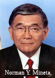 This entire route, except the segment between Quito Road and Prospect Road (~ SCL R12.846 to SCL R15.241), in Santa Clara
County is named the "Norman Y. Mineta Highway". It was named in
honor of Norman Y. Mineta. Born in 1931, in San Jose, California, Mr.
Mineta and his family were among the 120,000 Americans of Japanese
ancestry detained in internment camps during WWII. In 1953, Mr. Mineta
graduated from the University of California, Berkeley with a degree in
Business Administration. He then joined the United States Army and served
as an intelligence officer in Korea and Japan. From 1967 to 1971, Mr.
Mineta served as a member of the San Jose City Council and from 1971 to
1974, he served as Mayor of San Jose, thereby becoming the first
Asian-American mayor of a major United States city. From 1975 to 1995, Mr.
Mineta represented the Silicon Valley area as a Member of the United
States House of Representatives, where his legislative and policy agenda
was wide and varied, including major projects in the areas of economic
development, science and technology policy, trade, transportation, the
environment, intelligence, the budget, and civil rights. As a Member of
Congress, Mr. Mineta cofounded the Congressional Asian Pacific American
Caucus and served as its first chair; he also chaired the House Public
Works and Transportation Committee from 1992 to 1994, chaired that
committee's aviation subcommittee from 1981 to 1988, and chaired its
Surface Transportation Subcommittee from 1989 to 1991. He was also a key
author of the landmark Intermodal Surface Transportation Efficiency Act of
1991, which shifted decisions concerning highway and mass transit planning
to state and local governments and led to major upsurges in mass transit
ridership and more environmentally friendly transportation projects. Mr.
Mineta was also the driving force behind the passage of the Civil
Liberties Act of 1988, which officially apologized for and redressed the
injustices endured by Japanese Americans during World War II. After
leaving Congress, Mr. Mineta chaired the National Civil Aviation Review
Commission, which in 1997 issued recommendations on reducing traffic
congestion and the aviation accident rate, many of which were adopted by
the Clinton administration. In 2000, President Clinton appointed Mr.
Mineta United States Secretary of Commerce, making Mr. Mineta the first
Asian American to hold a post in the Presidential Cabinet. In 2001,
President George W. Bush appointed Mr. Mineta United States Secretary of
Transportation, making Mr. Mineta the only Democrat to serve in George W.
Bush's Cabinet and the first Cabinet member to switch directly from a
Democratic to a Republican Cabinet. During Mr. Mineta's first four years
as Secretary of Transportation, the United States saw the lowest vehicle
fatality rate ever recorded, the highest safety belt usage rate ever
recorded, and the lowest rail fatality level ever recorded. As Secretary
of Transportation, Mr. Mineta oversaw the safest three-year period in
aviation history and was instrumental in persuading every state in the
country to set a maximum blood alcohol content level for automobile
drivers at 0.08 percent, a level that has proved to be effective in
preventing automobile crashes and improving automobile safety. Mr. Mineta
also oversaw the United States Coast Guard's response to the terrorist
attacks of September 11, 2001, including expanding the number and mission
of Coast Guard Port Security Units and developing the Sea Marshal Program
and Maritime Safety and Security Teams. Mr. Mineta also guided the
creation of the Transportation Security Administration, an agency of more
than 60,000 employees charged with protecting Americans as they travel
across the United States. On June 23, 2006, Mr. Mineta announced his
resignation as United States Secretary of Transportation, effective July
7, 2006, making him the longest-serving Secretary of Transportation in the
history of the Department of Transportation. Named by Assembly Concurrent
Resolution (ACR) 25, Resolution Chapter 66, on 7/3/2007.
This entire route, except the segment between Quito Road and Prospect Road (~ SCL R12.846 to SCL R15.241), in Santa Clara
County is named the "Norman Y. Mineta Highway". It was named in
honor of Norman Y. Mineta. Born in 1931, in San Jose, California, Mr.
Mineta and his family were among the 120,000 Americans of Japanese
ancestry detained in internment camps during WWII. In 1953, Mr. Mineta
graduated from the University of California, Berkeley with a degree in
Business Administration. He then joined the United States Army and served
as an intelligence officer in Korea and Japan. From 1967 to 1971, Mr.
Mineta served as a member of the San Jose City Council and from 1971 to
1974, he served as Mayor of San Jose, thereby becoming the first
Asian-American mayor of a major United States city. From 1975 to 1995, Mr.
Mineta represented the Silicon Valley area as a Member of the United
States House of Representatives, where his legislative and policy agenda
was wide and varied, including major projects in the areas of economic
development, science and technology policy, trade, transportation, the
environment, intelligence, the budget, and civil rights. As a Member of
Congress, Mr. Mineta cofounded the Congressional Asian Pacific American
Caucus and served as its first chair; he also chaired the House Public
Works and Transportation Committee from 1992 to 1994, chaired that
committee's aviation subcommittee from 1981 to 1988, and chaired its
Surface Transportation Subcommittee from 1989 to 1991. He was also a key
author of the landmark Intermodal Surface Transportation Efficiency Act of
1991, which shifted decisions concerning highway and mass transit planning
to state and local governments and led to major upsurges in mass transit
ridership and more environmentally friendly transportation projects. Mr.
Mineta was also the driving force behind the passage of the Civil
Liberties Act of 1988, which officially apologized for and redressed the
injustices endured by Japanese Americans during World War II. After
leaving Congress, Mr. Mineta chaired the National Civil Aviation Review
Commission, which in 1997 issued recommendations on reducing traffic
congestion and the aviation accident rate, many of which were adopted by
the Clinton administration. In 2000, President Clinton appointed Mr.
Mineta United States Secretary of Commerce, making Mr. Mineta the first
Asian American to hold a post in the Presidential Cabinet. In 2001,
President George W. Bush appointed Mr. Mineta United States Secretary of
Transportation, making Mr. Mineta the only Democrat to serve in George W.
Bush's Cabinet and the first Cabinet member to switch directly from a
Democratic to a Republican Cabinet. During Mr. Mineta's first four years
as Secretary of Transportation, the United States saw the lowest vehicle
fatality rate ever recorded, the highest safety belt usage rate ever
recorded, and the lowest rail fatality level ever recorded. As Secretary
of Transportation, Mr. Mineta oversaw the safest three-year period in
aviation history and was instrumental in persuading every state in the
country to set a maximum blood alcohol content level for automobile
drivers at 0.08 percent, a level that has proved to be effective in
preventing automobile crashes and improving automobile safety. Mr. Mineta
also oversaw the United States Coast Guard's response to the terrorist
attacks of September 11, 2001, including expanding the number and mission
of Coast Guard Port Security Units and developing the Sea Marshal Program
and Maritime Safety and Security Teams. Mr. Mineta also guided the
creation of the Transportation Security Administration, an agency of more
than 60,000 employees charged with protecting Americans as they travel
across the United States. On June 23, 2006, Mr. Mineta announced his
resignation as United States Secretary of Transportation, effective July
7, 2006, making him the longest-serving Secretary of Transportation in the
history of the Department of Transportation. Named by Assembly Concurrent
Resolution (ACR) 25, Resolution Chapter 66, on 7/3/2007.
(Image source: Wikipedia)
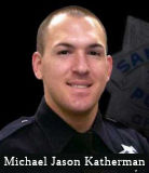 The portion of Route 85 from PM SCL 5.222 to PM SCL 6.136
in the County of Santa Clara is named the “Michael
“Mike” Jason Katherman Memorial Highway”. It was
named in memory of Michael “Mike” Jason Katherman of the San
Jose Police Department, who was born in San Jose. Mike was raised in the
City of San Jose, California, where he attended Valley Christian High
School, graduating in 2000; Mike continued his education and earned a
bachelor’s degree in business administration from Simpson College in
the City Of Redding. It was during college that Mike felt the calling to
follow through on his dream of becoming a police officer. Mike got a job
as a loss-prevention officer while he applied to the San Jose Police
Department, where in July 2005, he was sworn into the force where he
eventually became a motorcycle officer as part of the department’s
traffic enforcement unit. Mike was a director on the Police Chaplaincy
Board and the Vice President of the Keith Kelley Club, an internal
organization that provides support for officers and their families who
endure hard times. As a patrol officer, Mike stood out, earning the
department’s Outstanding Police Duty Award in 2009. On June 14,
2016, Mike was on patrol in the City of San Jose when he was struck by
another vehicle. Witnesses attempted to assist Mike, but he succumbed to
his injuries. Named by Assembly Resolution ACR 173, Res. Chapter 160, 08/30/22.
The portion of Route 85 from PM SCL 5.222 to PM SCL 6.136
in the County of Santa Clara is named the “Michael
“Mike” Jason Katherman Memorial Highway”. It was
named in memory of Michael “Mike” Jason Katherman of the San
Jose Police Department, who was born in San Jose. Mike was raised in the
City of San Jose, California, where he attended Valley Christian High
School, graduating in 2000; Mike continued his education and earned a
bachelor’s degree in business administration from Simpson College in
the City Of Redding. It was during college that Mike felt the calling to
follow through on his dream of becoming a police officer. Mike got a job
as a loss-prevention officer while he applied to the San Jose Police
Department, where in July 2005, he was sworn into the force where he
eventually became a motorcycle officer as part of the department’s
traffic enforcement unit. Mike was a director on the Police Chaplaincy
Board and the Vice President of the Keith Kelley Club, an internal
organization that provides support for officers and their families who
endure hard times. As a patrol officer, Mike stood out, earning the
department’s Outstanding Police Duty Award in 2009. On June 14,
2016, Mike was on patrol in the City of San Jose when he was struck by
another vehicle. Witnesses attempted to assist Mike, but he succumbed to
his injuries. Named by Assembly Resolution ACR 173, Res. Chapter 160, 08/30/22.
(Image source: ABC 7)
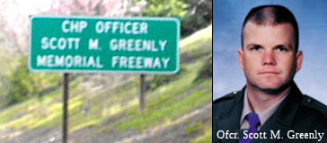 The portion between Quito Road and Prospect Road in the City of Saratoga (~ SCL
R12.846 to SCL R15.241) is named the "CHP Officer Scott M. Greenly
Memorial Freeway". It was named by Assembly Concurrent Resolution
172, Chapter 140 in 1998. California Highway Patrol Officer Scott M.
Greenly, 31, was killed in the line of duty on January 7, 1998. Officer
Greenly was killed while making a routine traffic stop before the Saratoga
Avenue exit to Route 85 when an out-of-control driver slammed into him as
he petted the dog of the woman he had pulled over. Officer Greenly's death
prompted the state to pass the "move over'' statute, requiring drivers to
move into another lane (if it can be done safely) when they spot an
emergency vehicle on the side of the road.
The portion between Quito Road and Prospect Road in the City of Saratoga (~ SCL
R12.846 to SCL R15.241) is named the "CHP Officer Scott M. Greenly
Memorial Freeway". It was named by Assembly Concurrent Resolution
172, Chapter 140 in 1998. California Highway Patrol Officer Scott M.
Greenly, 31, was killed in the line of duty on January 7, 1998. Officer
Greenly was killed while making a routine traffic stop before the Saratoga
Avenue exit to Route 85 when an out-of-control driver slammed into him as
he petted the dog of the woman he had pulled over. Officer Greenly's death
prompted the state to pass the "move over'' statute, requiring drivers to
move into another lane (if it can be done safely) when they spot an
emergency vehicle on the side of the road.
(Image source: Waymarking, Calif. Highway Patrol Memorial)
This route is named the "Stevens Creek Freeway" from Route 280 to Route 101 in Mountain
View (~ SCL R18.487 to SCL R23.763). It was named after Stevens Creek,
which in turn was named after Captain Elisha Stephens, the first man to
lead a wagon train across the Sierras in 1844. All 50 of the pioneers
survived the trip, as well as two infants born during the journey. In
1848, Stephens settled east of the creek that bears his name. The 160-acre
homestead, called Blackberry Farm, still exists today by Stevens Creek
Boulevard in Monta Vista. Widely regarded as an eccentric, Stephens
befriended two inventors who cluttered his yard with perpetual motion
machines and steam-driven plows. Neighbors politely declined his
invitations to dinner because the main course was usually rattlesnake.
Stephens claimed, "You don't know what's good! Rattlesnakes beat frogs all
to pieces." Popular legend credited Stephens with capturing and eating
most of the rattlesnakes around Stevens Creek. Stephens moved to Kern
County, near Bakersfield, where he died in 1887.
(Source: Mountain View Voice)
 Named Structures
The intersection of Route 85 and US 101 (~ SCL R23.763) in San Jose is named the Michael Evanhoe Interchange. It was named in honor of Michael Evanhoe, who served between 1995 and 2004 as the chief development officer responsible for the planning, programming, project development, marketing, and congestion management functions for the Santa Clara Valley Transportation Authority (VTA) in the County of Santa Clara. In that position, Mr. Evanhoe managed the $700 million VTA highway program, and was responsible for long-range transportation planning and programming for VTA, working to address and set the VTA's priorities for discretionary state and federal transportation funds. Mr. Evanhoe worked in the field of transportation since 1965, initially with the Caltrans in its Sacramento, Marysville, and San Francisco offices from 1965 to 1974, and later serving as Assistant Secretary for Transportation in the Business, Transportation and Housing Agency from 1975 to 1978 and Executive Director of the California Transportation Commission from 1978 to 1984. He joined the Sunset Development Company in San Ramon in 1984 and served as Vice President of Operations until 1988, was later appointed as Executive Director of the Golden Triangle Task Force in Santa Clara County from 1988 to 1990, and was subsequently appointed as the Executive Director of the Congestion Management Agency of Santa Clara County in 1990, serving in the latter position until the agency merged with the Santa Clara County Transit District in 1994 to form the VTA. Over the years, Mr. Evanhoe has gained the respect and admiration of elected officials, staff, and business leaders by getting the job done, maintaining a positive work environment, taking on new challenges, and working collaboratively with others. He had substantial responsibilities for construction of the Route 85/US 101 interchange and the widening of US 101. Named by Assembly Concurrent Resolution 152, chaptered September 1, 2004. Resolution Chapter 175.
 Memorials
Alma Ribbs, Just past Saratoga Ave (~SCL R13.698). This sign was placed by her husband, Richard Wyckoff. The sign includes the names of Alma and the children. Alma Ribbs was seven months' pregnant when she and the twin babies she was carrying (Nina and Robert) were killed by a drunken driver on Route 85 in 1996.
 Commuter Lanes
Commuter lanes exist along the entire freeway. The portion between Route 280 and Route 237 was opened in February 1990 (NB) and April 1990 (SB). The portion between US 101 and Route 82 was opened in August 1994; the remainder (Route 82 to Route 280) was opened in October 1994. The lanes from Route 237 to US 101 in Mountain View opened in 1998. They all require two or more occupants, and are in operation weekdays between 5:00 AM and 9:00 AM, and between 3:00 PM and 7:00 PM.
HOV lanes also exist in Mountain View between Dana Street and Route 101.
With respect to usage: A 2001 Caltrans survey showed that 6,814 vehicles rode in the carpool lane between Almaden Expressway and I-280, up from 4,837 in 1996.
 Classified Landcaped Freeway
The following segments are designated as Classified Landscaped Freeway:
| County | Route | Starting PM | Ending PM |
| Santa Clara | 85 | 0.00 | 1.45 |
| Santa Clara | 85 | 1.74 | 2.42 |
| Santa Clara | 85 | 2.80 | 3.08 |
| Santa Clara | 85 | 3.21 | 3.48 |
| Santa Clara | 85 | 3.55 | 5.41 |
| Santa Clara | 85 | 5.88 | R10.81 |
| Santa Clara | 85 | R10.86 | R15.57 |
| Santa Clara | 85 | 15.70 | R23.87 |
 Freeway
[SHC 253.1] Entire route. Added to the Freeway and Expressway system in 1959.
 Exit Information
 Other WWW Links
 National Trails
 This route is part of the De Anza National Historic Trail.
 Statistics
Overall statistics for Route 85:
 Pre-1964 Legislative Route
In 1933, the route that would beomce LRN 85 was defined as the route from "[LRN 1] to [LRN 20] N of Mad River". In 1935, it was codified into the highway code as:
This definition remained unchanged until 1963. This route is present-day unsigned Route 200.
© 1996-2024 Daniel P. Faigin.
Maintained by: Daniel P. Faigin
<webmaster@cahighways.org>.

 From Route
  Route 84
 Route 86