
 California Highways:
Click here for a key to the symbols used. An explanation of acronyms may be found at the bottom of the page.
 Routing
 No current routing.
 Post 1964 Signage History
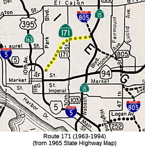
 In 1963, Route 171 was defined as "Route 5 near San Diego to Route 805 via Switzer Canyon."
In 1994, the previous routing for Route 171, from Route 5 near San Diego to Route 805 via Switzer Canyon, was deleted per AB 3132, Chapter 1220. This was part of a road system first proposed in 1926. It would have started at I-5 near downtown San Diego, run northeast to connect with I-805 near the I-8 junction, crossing several canyons, residential areas, and the Balboa Park Municipal Golf Course. A remnant of what was to be a freeway-to-freeway connection exists at the I-5 and Pershing Drive/B Street interchange (Exit 15B).
According to Tom Fearer, Switzer Canyon was the subject of numerous
proposals by the San Diego City Council to be added to the City Park
System beginning in the late 1970s. This culminated in 1987 when the
City of San Diego purchased Switzer Canyon which effectively blocked the
planned route of Route 171.
(Source: Tom Fearer, Gribblenation Blog "Paper Highways of San Diego; unbuilt California State Route 157, 171, and 252")
 Pre 1964 Signage History
The 1964-1994 routing of Route 171 was LRN 284, defined in 1959. It was never signed.
Route 171 was not defined as part of the initial state signage of routes in 1934. It is unclear what (if any) route was signed as Route 171 between 1934 and 1964.
 Naming
 Other WWW Links
 Freeway
Originally to have been freeway; later deleted from SHC 253.1.
 Pre-1964 Legislative Route
In 1933, Chapter 767 defined the route from "[LRN 60] near Huntington Beach to Whittier" as part of the state highway system. In 1935, this was added to the highway code as LRN 171, with the routing:
In 1951, Chapter 1562 truncated the terminus: "… to [LRN 2]
near Whittier [LRN 62] at or near Buena Park"
This route ran from Route 1 near Huntington Beach to LRN 62 as along Hampshire Ave (now Beach Blvd), Huntington Beach Blvd (now Beach Blvd), Stanton Blvd (now Beach Blvd), and Grand Blvd (now Beach Blvd) as Sign Route 39, where Sign Route 39 split off on LRN 62 La Mirada Ave (again, now Beach Blvd). The routing then continued along LRN 171 as Sign Route 26 along La Mirada Road (now Stage Road), Valley View Ave to Telegraph, and then along Telegraph. When Telegraph (LRN 166) split off to run W, LRN 171 continued along Los Nietos to Santa Fe Springs Road to meet LRN 2 at Whittier.
When LRN 166 was redefined in 1941 to terminate into LRN 174 instead of LRN 171 (as part of the effort to make LRN 166 Bypass US 101), all of LRN 171 N of LRN 62 was signed as Sign Route 26 (although some Sign Route 26 signage may have remained along Anaheim-Telegraph Road to Olympic.
The 1951 truncation removed the Sign Route 26 portion of LRN 171 (i.e., N of LRN 62) from the state highway system.
; this portion N of LRN 166 is the segment deleted in 1951.
© 1996-2024 Daniel P. Faigin.
Maintained by: Daniel P. Faigin
<webmaster@cahighways.org>.

 Route 170
 Route 172