
 California Highways:
Click here for a key to the symbols used. An explanation of acronyms may be found at the bottom of the page.
 Routing
 No current routing.
 Post 1964 Signage History
 As defined in 1963, this route ran from "Route 198 to Route 180
near the General Grant Grove section of Kings Canyon National Park."
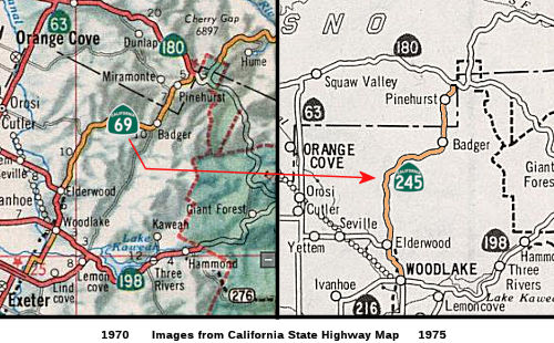
In 1972, Chapter 1216 repealed the definition of the route and renumbered it as Route 245. Rumor has it that the renumbering was due to continual theft of the Route 69 signs.
 Pre 1964 Signage History
This was originally part of Route 65, and was renumbered as Route 69 when a new alignment was proposed for Route 65 in 1964. Route 69 was not signed as part of the original 1964 state signage or the original 1934 signate of state routes. This was part of LRN 129, defined in 1933.
 National Trails
 The portion of this route between Route 99 and Kings Canyon
National Park was part of the National Park to Park Highway.
The portion of this route between Route 99 and Kings Canyon
National Park was part of the National Park to Park Highway.
 Pre-1964 Legislative Route
▸The route that would become LRN 69 was first defined in 1925, by Chapter 82, which stated “All that portion of the public highway commencing at Irwin Street, within the corporate limits of the city of San Rafael, in Marin county, California, and leading therefrom to Point San Quentin, in Marin county, California, and known as the San Rafael-San Quentin road is hereby declared to be a state highway...”
Irwin Street was the original routing for what would become US 101. Point San Quentin is the point at where, today, the Richmond-San Rafael Bridge lands on its western end. Note that this original highway did not cross the bay
▸In 1933, a segment was added to the route running from San Jose to Richmond (what would become the East Shore Highway). In 1935, it was defined in the highway code as:
This route includes two of the San Francisco-Oakland Bay Bridge approaches (on the Alameda County end) described in Section 1 of Chapter 9, Statutes of 1933, one which starts approximately at the intersection of Cypress and Seventh Streets in Oakland, and one which starts at a point on the westerly side of Ninth Street in the vicinity of Ashby Avenue in Berkeley.
Note that this routing, again, did not include the Richmond-San Rafael bridge (which did not exist—instead, there was a private ferry across the bay and Cutting Blvd was not a state highway). The 1936 State Highway Map shows two segments: One in San Rafael extending from US 101 to Point San Quentin, and one starting in Richmond, roughly at the point where San Pablo meets East Shore Blvd S of Cutting Blvd. Continuing S (because highways tended to be described N to S back then), this second segment went down the East Shore Highway to the approach to the San Francisco-Oakland Bay Bridge, feeding into the bridge as well as an overpass to Cypress, down Cypress to Seventh, across Seventh to Harrison, down Harrison through the Posey Subway to Webster, across Central, Encinal (possibly, at one time, San Jose), Park, and Otis to Maitland, and then down Maitland to Davis Street. The route then went across Davis to meet LRN 105 at Fourteenth, where it continued down Washington towards San Jose. In terms of later signage, this included what was Sign Route 17 (and later I-80) N of the Bay Bridge, and what is now Route 61 through Oakland to Davis Street. Fourteenth, and 12th to Cypress (now Mandela Parkway) at the time, was Sign Route 17 to the Bay Bridge.
▸In 1937, Chapter 841 changed the Berkeley approach to be "the north and south portions of the one which starts at a point on the westerly side of Ninth Street in the vicinity of Ashby Avenue in Berkeley"
▸In 1947, Chapter 1233 removed the Bay Bridge approaches, and added the following third segment: "Route (b) above near Buchanan Street Extension in Albany to a point in Western Drive approximately 1,900 feet northwesterly of Scofield Avenue, Richmond." This was summarized on the 1949 map as "San Rafael to Point San Quentin; [LRN 14] in Richmond to San Jose; near Scofield Avenue in Richmond to near Buchanan Street Extension in Albany."
The added segment later became part of I-580 (note that there was also a parallel extension of Route 61 planned, which was LRN 257, and was never built), but was originally was the Richmond Access Highway, Potrero, Hermann (now Hoffman), and Cutting. The route then ran up Garrard, Ea Standard, near Chevron Way, across Marine and Scofield to Western Ave. 1947 also saw the creation of LRN 252 (which became part of LRN 226 in 1949), which subsumed the former routing of LRN 69 along what became Route 61 and Route 112; and LRN 226, which was originally Route 24 but became I-980. LRN 69 was then rerouted to the current Nimitz Freeway routing.
▸In 1957, Chapter 36 deleted the new Richmond (c) segment, and reworded the second segment to be "San Jose to the Richmond-San Rafael Toll Plaza" (which removed the original (b) routing in Richmond)
This reflected the planned construction of the Richmond-San Rafael Bridge, which was originally not part of the state highway system. It wasn't until 1959 that Route 17 was extended over the Richmond-San Rafael Bridge to meet US 101. The Richmond-San Rafael Bridge is a double deck truss bridge spanning 5.5 miles with a maximum clearance of 185 feet. The Richmond-San Rafael Bridge connects Richmond in Contra Costa County and San Rafael in Marin County. Construction on the Richmond-San Rafael Bridge started in 1953 and was completed by 1956.
▸In 1959, Chapter 1062 added a "a connection to LRN 5 near Warm Springs" to (b), and extended (a) to [LRN 56] near Point Reyes Station. It also swapped the segments. The resulting route was signed as follows:
All of this route was signed as part of Route 17, although in Oakland, portions of Route 17 were signed along LRN 105 (at least in 1938), with LRN 69 being used for the current route of Route 112, Route 61 / Route 260, and down near Warm Springs, Route 262. It currently includes portions of the following: Route 17, I-880, I-80, and I-580. It also appears that, for a time, Sign Route 17 was along LRN 5 between San Jose and Warm Springs.
This was originally part of Route 17, and is present-day Route 251.
What is interesting here is that the Richmond-San Rafael Bridge was not part of LRN 69. The state highway maps from the time show it as part of Sign Route 17, but it seems to be excluded from the legislative definition of the route.
© 1996-2024 Daniel P. Faigin.
Maintained by: Daniel P. Faigin
<webmaster@cahighways.org>.

 Route 68
 Route 70