
 California Highways:
Click here for a key to the symbols used. An explanation of acronyms may be found at the bottom of the page.
 Routing
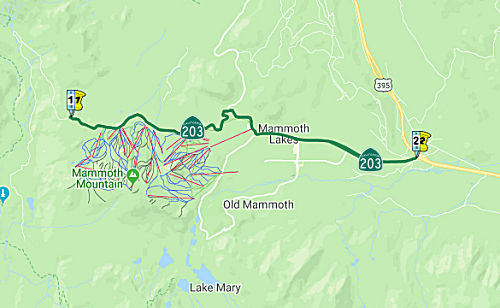 From the Mono county line near Minaret Summit to Route 395.
  Post 1964 Signage History
▸As defined in 1963, this route ran from "Mammoth Lakes to Route 395."
 In 1955-1956, studies were begun for a trans-Sierra highway across Mammoth Pass. Assembly Joint
Resolution 5, adopted in 1955, asked the President and Congress to have
Mammoth Pass Road constructed as a National Defense Highway. Conservation
groups mobilized in 1957. In 1958, the highway study reported that the
route was feasible, and in 1960 Mammoth Pass Road was placed in the FAS
system as FAS 962. Senate Joint Resolution 43, in 1961, requested the
inclusion of the road in the Forest Highway System and its construction by
the Bureau of Public Roads (BPR). A 1957 study by the BPR proposed the
construction of the 32.8 mi gap as a Class II Forest Highway with 7%
maximum grades, a 32' all paved roadway, and 40 mph design
standards. In 1962, Forest Highway Route 100 was officially
included in the Forest Highway System from FH 74 near North Fork to FH 81,
Mammoth Lake Road (Route 203). Funds were appropriated for a survey in
1964. In 1965, the Minaret Summit Highway was proposed, as an all-weather
highway from North Fork in Madera County to the Devil's Postpile and
Bishop by way of Sheep's Crossing, 77 Corral and Granite Stairway. In
1966, a study was undertaken at the request of the legislature (SCR 89,
1965) on the feasibility of a trans-Sierra highway connecting I-5 W of Los
Banos to the California Nevada State Line near Benton Station, passing
near Califa, North Fork, and Minaret Summit. The eventual plan was to make
this an extension of I–70. Once the route crested the Sierras
at Minaret Summit, and entered Caltrans District IX, it would have gone
through the community of Mammoth Lakes, crossed Crowley Lake at about the
mid-point on a trestle, followed the alignment of Benton Crossing Road,
past Old Benton, and onto the state line where US 6 intersects. The
reported noted that except for a 32 mile unconstructed gap between Squaw
Dome and Minaret Summit, a traversable route exists between the termini
and within the corridor. The route was 239 miles in length, and used Route 152, Route 99, Route 145, Route 41, Route 203, US 395, Route 120, and US 6
for a distance of 103 miles. The report also noted that construction and
maintenance costs were excessive for the small amount of winter traffic.
In 1966, construction costs were estimated at $125 million with an
addition $6.5 million per year for maintenance. In 1967, the Assembly
Transportation Committee refused to include this highway in the state
highway system. In late 1967, there were some discussions about a tunnel
under Sonora Pass. In 1968, another attempt was made to put the route in
the state highway system (AB 1191); that failed in committee due to
opposition from conservation groups and Southern California legislators
who did not want more miles in the state highway system to compete with
their highways. In 1969, funding was allocated to build a road between
Minaret Summit and Devil's Postpile Road. In 1971, there was a draft EIR
for FH 100-4(1) [the source for the images to the right], but there was
considerable opposition to construction through the wilderness areas.
In 1955-1956, studies were begun for a trans-Sierra highway across Mammoth Pass. Assembly Joint
Resolution 5, adopted in 1955, asked the President and Congress to have
Mammoth Pass Road constructed as a National Defense Highway. Conservation
groups mobilized in 1957. In 1958, the highway study reported that the
route was feasible, and in 1960 Mammoth Pass Road was placed in the FAS
system as FAS 962. Senate Joint Resolution 43, in 1961, requested the
inclusion of the road in the Forest Highway System and its construction by
the Bureau of Public Roads (BPR). A 1957 study by the BPR proposed the
construction of the 32.8 mi gap as a Class II Forest Highway with 7%
maximum grades, a 32' all paved roadway, and 40 mph design
standards. In 1962, Forest Highway Route 100 was officially
included in the Forest Highway System from FH 74 near North Fork to FH 81,
Mammoth Lake Road (Route 203). Funds were appropriated for a survey in
1964. In 1965, the Minaret Summit Highway was proposed, as an all-weather
highway from North Fork in Madera County to the Devil's Postpile and
Bishop by way of Sheep's Crossing, 77 Corral and Granite Stairway. In
1966, a study was undertaken at the request of the legislature (SCR 89,
1965) on the feasibility of a trans-Sierra highway connecting I-5 W of Los
Banos to the California Nevada State Line near Benton Station, passing
near Califa, North Fork, and Minaret Summit. The eventual plan was to make
this an extension of I–70. Once the route crested the Sierras
at Minaret Summit, and entered Caltrans District IX, it would have gone
through the community of Mammoth Lakes, crossed Crowley Lake at about the
mid-point on a trestle, followed the alignment of Benton Crossing Road,
past Old Benton, and onto the state line where US 6 intersects. The
reported noted that except for a 32 mile unconstructed gap between Squaw
Dome and Minaret Summit, a traversable route exists between the termini
and within the corridor. The route was 239 miles in length, and used Route 152, Route 99, Route 145, Route 41, Route 203, US 395, Route 120, and US 6
for a distance of 103 miles. The report also noted that construction and
maintenance costs were excessive for the small amount of winter traffic.
In 1966, construction costs were estimated at $125 million with an
addition $6.5 million per year for maintenance. In 1967, the Assembly
Transportation Committee refused to include this highway in the state
highway system. In late 1967, there were some discussions about a tunnel
under Sonora Pass. In 1968, another attempt was made to put the route in
the state highway system (AB 1191); that failed in committee due to
opposition from conservation groups and Southern California legislators
who did not want more miles in the state highway system to compete with
their highways. In 1969, funding was allocated to build a road between
Minaret Summit and Devil's Postpile Road. In 1971, there was a draft EIR
for FH 100-4(1) [the source for the images to the right], but there was
considerable opposition to construction through the wilderness areas.
(Source: Research by Tom Fearer, 3/2024: Division of Highways, Forest Highway 100 Study - Route 41 to Route 395 via Minaret Summit, December 1966, in Caltrans file for Route 203)
▸In 1967, Chapter 1323 extended the route from the Mono County Line
to Mammoth Lakes: "the Mono county line near Minaret Summit Mammoth
Lakes to Route 395."
 In 1967, a memo was produced assessing the impact of the 1967 legislative definition change.
It noted that the redesignation "necessitates the relinquishment of 4.78
miles of existing Route 203 from Mammoth Lakes (Horseshoe Lake) to the
junction with Minaret Summit Road in the community of Mammoth Lakes, and
allows the assumption of maintenance of Minaret Summit Road between the
Mono County Line at Minaret Summit and the Community of Mammoth Lakes." It
noted the existing route could not be relinquished until January 1, 1968.
A route adoption map was subsequently produced, and recommended the
adoption of the 5.5 mile portion of Minaret Summit Road. The existing road
was acceptable for maintenance. The county accepted relinquishment
of the segment by resolution № 36-67, dated 10/3/1967. It renamed
the relinquished road Lake Mary Road, and noted it was County Road №
101.
In 1967, a memo was produced assessing the impact of the 1967 legislative definition change.
It noted that the redesignation "necessitates the relinquishment of 4.78
miles of existing Route 203 from Mammoth Lakes (Horseshoe Lake) to the
junction with Minaret Summit Road in the community of Mammoth Lakes, and
allows the assumption of maintenance of Minaret Summit Road between the
Mono County Line at Minaret Summit and the Community of Mammoth Lakes." It
noted the existing route could not be relinquished until January 1, 1968.
A route adoption map was subsequently produced, and recommended the
adoption of the 5.5 mile portion of Minaret Summit Road. The existing road
was acceptable for maintenance. The county accepted relinquishment
of the segment by resolution № 36-67, dated 10/3/1967. It renamed
the relinquished road Lake Mary Road, and noted it was County Road №
101.
(Source: Research by Tom Fearer, 3/2024: Memo: Assumption of Maintenance of 09-Mno-203, 10/25/1967, in Caltrans file for Route 203)
▸In 2023, SB 606, Chapter 619, 10/8/2023, authorized relinquishment within the Town of Mammoth Lakes by adding subsection (b)
Between US 395 and Mammoth Lakes, an "Old State Highway" parallels Route 203, taking a much more winding course along Mammoth Creek and running through Mammoth Creek Park. It reconnects with Route 203 at Sawmill Road, just west of the current interchange with the US 395 expressway. (This road is named "Old State Highway" in Compass's map and in Mapquest, but is named "Mammoth Creek Road" in MSN's mapping service.)
Note that the road actually does not end at Minaret Summit. Starting at US 395, the road is open all year round to the town of Mammoth Lakes at about 7,800 feet and to Mammoth Mountain Ski Area Main Lodge and Mammoth Mountain Inn at about 8,950 elevation. In the winter, the road is not plowed past that point. It opens to the public around mid June depending on the snow. It continues up to Minaret Summit, and then it goes down into The San Joaquin River Middle Fork valley (although past Minaret Summit, the road is not longer part of the state highway system, although it may be maintained by the park service). While in the valley there is a turn off for Devil’s Postpile. This turn off goes right to the river. During most of the summer there is a shuttle bus from Mammoth Mountain Inn to the San Joaquin River Middle Fork valley, Devil’s Postpile, and the 2 stables in the valley. From about 7:00 am to 7:00 pm most car traffic is not allowed and you have to take the shuttle bus. There is not enough parking in the valley. The road from the Inn to the summit is great. From the summit the road goes diagonally down a slope. This part of the road is narrow and sometimes downhill vehicles have to back up hill to allow uphill vehicles to pass. Usually if the vehicles are not too wide and drivers plan ahead only slowing down is needed. When the road gets to the valley it makes almost a complete U turn. It then goes down the valley a few miles. This part of the road is again wide enough for 2 way traffic. There are multiple bus stops in the valley. More information is available at www.nps.gov for Devil’s Postpile. Fishing and camping are also possible in the valley. The John Muir Trail and Pacific Crest Trail are also down there.
There was once a proposal to extend Route 203/LRN 112 across the Sierras.
At the time, in the throes of the Cold War and on the heels of World War
II, where Eisenhower saw how the German war machine benefitted from the
autobahns, the nation’s defense was one of the principal reasons
forwarded for building the road. As Madera County Supervisor Carl W.
McCollister said: “The road was necessary to give people in the San
Joaquin Valley their rightful highway outlet to the east should coastal
cities become targets of nuclear attack.” Ultimately, however,
opponents of the road argued that the road was impractical and made zero
business sense. Genny Smith, ringleader, organizer, activist, scribe who
fought the road over nearly three decades, commented, “it was
businessmen like Bob [Schotz] who made the difference. This road was a
business proposition from the get-go and a poor one at that. He and his
colleagues knew it and were willing to stand up and say so.” It was
finally stopped during the Reagan Administration (as in, when he was
Governor).
(Source: The Sheet, 8/2/2014, via AARoads)
 Pre 1964 Signage History
This was LRN 112, defined in 1933 and codified in 1935 as "[LRN 23] (US 395) to Mammoth Lakes" as a state highway. It was not signed before 1964. The proposal for the Minaret Summit highway and I–70 extension was likely LRN 234 (never signed).
Based on a 1935 Division of Highways map, LRN 112 when first defined used
the following alignment: (1) An unnamed dirt road east of the modern US 395 on the roadway known as "Old Highway"; (2) Mammoth Creek Road from the
west side of modern US 395 to Old Mammoth Road (shown on some maps now as
"Old State Highway"); (3) Old Mammoth Road through what is the original
town site of Mammoth; and (4) Lake Mary Road to Lake Mary.
(Source: Gribblenation Blog (Tom Fearer), "California State Route 203 the proposed Minaret Summit Highway", March 2024)
In 1933, there was a proposal to extend a forest highway between Devil's
Postpile and Mammoth: "The monument is now [1933] reached by means of a
steep, rough, tortuous road crossing the summit a mile north of Mammoth
Lakes, entirely unsuitable for travel. It is therefore proposed to include
in the forest highway system a project connecting with the improved State
and forest highway about 4 miles easterly of Mammoth Ranger Station and
extending through Mammoth Lakes recreation area, crossing the summit of
the Sierra at Mammoth Pass and descending to Red Meadows in the upper
region of the San Joaquin River, where is located the Devil's Postpile.
The project is 16 miles in length and is estimated to cost $500,000,
assuming that the standard adopted will be a two-lane road, with minimum
curvature around 800 feet and maximum gradiant around 6%. Since it is
being advocated by local interests that the Mammoth Lakes highway be
extended down the San Joaquin River to a connection with Sierra Way
between Yosemite Park and Shaver Lake, it appears desirable that the
standard and location for the Mammoth Lakes section should be selected,
having in mind possible development of a through highway."
(Source: Research by Tom Fearer, 3/2024: Burnett, Bruce B (US Forest Service), Forest Highways in California with connecting State and County Highways, 1933, in Caltrans file for Route 203)
The Forest Highway recommendation was made because, although the Mammoth
Lakes Road was part of the state system, the inclusion did not permit the
state to reconstruct the road. Making it a forest highway would allow
reconstruction of the highway.
(Source: Research by Tom Fearer, 3/2024: Burnett, Bruce B (US Forest Service), Forest Highways in California with connecting State and County Highways, 1933, in Caltrans file for Route 203)
The corridor of the proposed Minaret Summit Highway was studied heavily
between 1955-1967 as a possible extension of I–70 from Utah to I-5
near Los Banos. An attempt to add an extension of Route 203 over
Minaret Summit to Route 41 was proposed during 1968. The 1968
proposal was followed by plans to utilize the Minaret Summit corridor as a
Forest Service Road circa 1969-1971.
(Source: Gribblenation Blog (Tom Fearer), "California State Route 203 the proposed Minaret Summit Highway", March 2024)
In 1955-1956, studies were begun for a Trans-Sierra Highway across
Mammoth Pass. Assembly Joint Resolution 5, adopted in 1955, asked
the President and Congress to have the Mammoth Pass Road constructed as a
National Defense Highway. Environmental groups began to protest the
Mammoth Pass Road in 1957 and the route was found to be feasible via study
during 1958. In 1960, the Mammoth Pass Road was designated as FAS 962.
1961 Senate Joint Resolution 43 requested the inclusion of the road in the
Forest Highway System and its construction by the Bureau of Public
Roads. A 1957 study by the Bureau of Public Roads proposed
construction of the 32.8-mile gap as a Class II Forest Highway with 7%
maximum grades, 32-foot paved road deck and 40 MPH design. In 1962,
Forest Route (FR) 100 was officially included in the Forest Highway System
from FR 74 near North Fork to FR 81.
(Source: Gribblenation Blog (Tom Fearer), "California State Route 203 the proposed Minaret Summit Highway", March 2024)
 Status
In June 2016, the CTC authorized relinquishment of right of way in the Town of Mammoth Lakes along Route 203 between Mountain Boulevard and Minaret Road, consisting of a frontage road. The Town, by relinquishment agreement dated May 13, 2016, agreed to waive the 90-day notice requirement and accept title upon relinquishment by the State.
Route 203 (North Main Street) Sidewalk and Safety Project (~ MNO 5.09 to MNO R4.782)
In January 2021, the Town of Mammoth Lakes put out a
bid for The Route 203 (North Main Street) Sidewalk and Safety Project. The
environmental portion requires a review of the project area, CEQA/NEPA
documentation, and filing of a determination. The engineering design
portion of the project consists of Plans, Technical Specifications and
Estimates (PS&E) for a sidewalk along the north side of Main Street
from Minaret Road to Mountain Boulevard. The sidewalk requires the removal
of two existing retaining walls, the construction of new retaining walls
within the Town right-of-way, and maintaining a four foot shoulder for
bicycle travel. The sidewalk will be designed to manage stormwater and
comply with the ADA. The project will include a transit shelter and
informational signage for pedestrians and vehicular access. The majority
of the construction area is within the Caltrans right-of-way, requiring
construction to follow the conditions set by the Town of Mammoth Lakes and
Caltrans Encroachment Permit. The engineering design portion of the
project consists of Plans, Technical Specifications and Estimates
(PS&E) for a sidewalk along the west side of Minaret Road from Main
Street to the 8050 driveway. The path will be a combination of sidewalk
and a multi-use path, requiring the partial removal of an existing
retaining wall and the design of a small retaining wall adjacent to the
path to preserve the integrity of the Mammoth Fireside building
foundations. The sidewalk/path design will manage stormwater, comply with
the ADA, and identify necessary wayfinding signage. The majority of
construction will occur within the acquired right-of-way and may be
subject to right-of-way conditions limiting construction activities as
well as the conditions set by the Caltrans Encroachment Permit. Therefore,
the design may require special conditions for construction and require
staged construction activities.
(Source: Cached Bid Information)
In June 2021, the CTC approved amending the STIP to use
the funding available through the 2021 Mid-Cycle STIP and share
distribution of the federal Coronavirus Response and Relief Supplemental
Appropriations Act of 2021 funds (COVID Relief Funds) to add a new project
to the STIP: Main Street (Route 203) Multi-Use Path (PPNO 2683); program
$250K to the PS&E phase in FY 2021-22.
(Source: June 2021 CTC Agenda, Agenda Item
2.1a.(19))
 Scenic Route
[SHC 263.1] Entire route: Madera County Line near Minaret Summit to Route 395 (All)
Although this segment is eligible for Scenic Highway status, it has not yet met the criteria to be officially designated as Scenic Highway.
 Interregional Route
[SHC 164.19] Entire route.
 Other WWW Links
 Statistics
Overall statistics for Route 203:
 Pre-1964 Legislative Route
In 1935, Chapter 429 added the route “...from [LRN 26] near Oasis N-ly to Avenue 66 via Pierce Street.” with no number. In 1937, Chapter 841 deleted the 1935 definition and recreated it as LRN 203, with the same definition. This definition then remained unchanged until the 1963 renumbering.
This route ran from US 99 (present-day Route 86) near Oasis northerly to Avenue 66 via Pierce Street. This is part of present-day Route 195.
© 1996-2024 Daniel P. Faigin.
Maintained by: Daniel P. Faigin
<webmaster@cahighways.org>.

 Route 202
 Route 204