
 California Highways:
Click here for a key to the symbols used. An explanation of acronyms may be found at the bottom of the page.
 Routing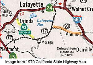
 Route 77 near Moraga to Route 24 near Orinda.
 Post 1964 Signage History
In 1963, the first two segments of this route were defined as "(a) Route 680 near Alamo to Route 77 near Burton. (b) Route 77 to Route 24 near Orinda."
In 1973, an article in the Valley Pioneer, dated 2/16/1973, reported that
due to strong opposition to the proposed freeways in the Alamo area,
transportation corridor studies on Route 93, Route 21 (which became
I-680), and Route 20 (unclear, as neither Sign Route 20 nor LRN 20 were in
this area -- perhaps they meant Route 77, which was LRN 233, and later,
LRN 235). Essentially, the article noted that the state had decided to
suspend indefinitely all plans for the routes. The article indicated that
the next goal was to get Route 93 removed from the list of legislatively
approved routes.
(Source: Mark Harrigan on FB, 2/11/2026)
In 1973, Chapter 602 deleted the first segment, leaving only "(a) Route 77 near Burton to Route 24 near Orinda." This segment appears to have been LRN 255. This portion would have followed the east side of the Robert Sibley Volcano Regional Preserve, then paralleled Pinehurst Road to Route 77 near the Upper San Leandro Reservoir. Route 93 would have multiplexed with Route 77 between there and Moraga (where the LRN 255 portion would split off).
Planned Route 93 was meant to be a freeway grade entirely contained
within Contra Costa County and would have traversed a relatively sparsely
populated part of the Diablo Range between Alamo westward to San Pablo.
(Source: Gribblenation Blog (Tom Fearer): "Paper Highways; Unbuilt California State Route 93")
In 1988, Chapter 106 clarified the definition: "(a) Route 77 near Burton
Moraga to Route 24 near Orinda."
 Pre 1964 Signage History
This routing was proposed, with no routing determined, in 1963. It was LRN 254, defined in 1959.
 Status
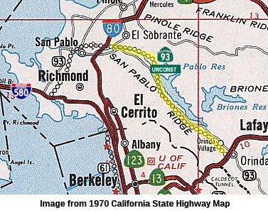 Route 24 near Orinda to Route 80 in Richmond and Pinole.
Post 1964 Signage HistoryIn 1963, this segment was defined as "(c) Route 24 near Orinda to Route 17 in Richmond via San Pablo." It was renumbered as (b) in 1973.
In 1988, Chapter 106 clarified the definition of (a) and split (b): "(a)
Route 77 near Burton Moraga to Route 24 near
Orinda. (b) Route 24 near Orinda to Route 17 Route 80 in
Richmond and Pinole. (c) Route 80 to Route 580 in Richmond via San
Pablo and north Richmond." This also reflected the renumbering
of Route 17 as I-580.
Pre 1964 Signage HistoryThis routing was proposed, with no routing determined, in 1963. It was LRN 254, defined in 1959. It runs roughly along San Pablo Dam Road.
Status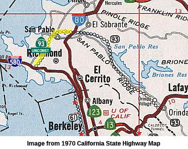 Route 80 to Route 580 in Richmond via San Pablo and north Richmond.
Post 1964 Signage HistoryThis segment was created from a split of the original 1963 (c) [Route 24 near Orinda to Route 17 in Richmond via San Pablo] in 1988.
Pre 1964 Signage HistoryThis routing was proposed, with no routing determined, in 1963. It was LRN 254, defined in 1959. It runs roughly along San Pablo Dam Road.
StatusThe 2013 Traversable Highways report notes that this segment of Route 93 was constructed as Richmond Parkway. No intention to adopt into system.
This is constructed to expressway standards. Note that Richmond Parkway (constructed by the City of Richmond), although it has callboxes signed "CC-93", is not part of the state highway at the present time. Those callboxes were placed by the County, not the state, and the highway is not up to state expressway standards. The city wants to eventually have the route incorporated into the state system; hence the numbering. According to Sean Tongson, a Contra Costa County transportation improvement plan booklet indicates that some of the planned improvements include raising $17 million dollars to improve the Richmond Parkway; the reasoning for this besides improving traffic safety and maintenance include prepping for 'the transfer of ownership to the California Department of Transportation'. The state will not accept the route until it meets state expressway standards.
Pre 1964 Signage HistoryRoute 93 was not defined as part of the initial state signage of routes in 1934. It is unclear what (if any) route was signed as Route 93 between 1934 and 1964.
 Freeway
[SHC 253.1] Entire route, all of which are unconstructed. Added to the Freeway and Expressway system in 1959.
 Other WWW Links
 Statistics
Overall statistics for Route 93:
 Pre-1964 Legislative Route
In 1933, the segment from "[LRN 65] near Cool via Georgetown to [LRN 65] near Placerville". In 1935, this routing was codified as LRN 93 in the highway code, and the definition remained unchanged until 1963. It ran from Route 49 near Cool via Georgetown to Route 49 near Placerville. This was unsigned before 1964, and is present-day Route 193.
© 1996-2024 Daniel P. Faigin.
Maintained by: Daniel P. Faigin
<webmaster@cahighways.org>.

 Route 92
 Route 94