
 California Highways:
Click here for a key to the symbols used. An explanation of acronyms may be found at the bottom of the page.
 Routing
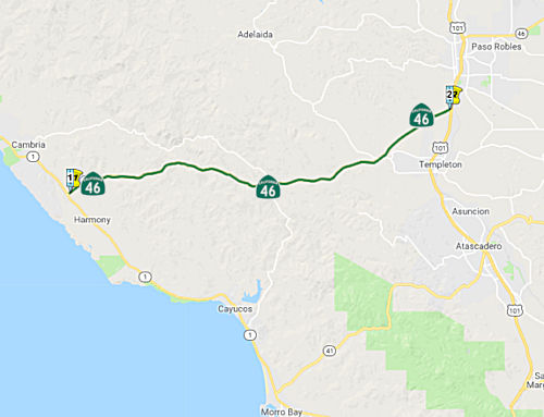 From Route 1 near Cambria to Route 101 near Paso Robles.
 Post 1964 Signage History
This segment is as defined in 1963.
 Pre 1964 Signage History
Between the initial state signage of routes in 1934 and the 1964 signed/legislative route alignment, this segment was signed as Route 41, and was a 1933 extension of LRN 33. It ran along Santa Rosa Creek Road until re-aligned sometime around 1970 to the current routing along Green Valley to Cambria. See the map below.
 Status
Templeton Roundabout (05-SLO-46 R17.2/R17.6)
In October 2017, it was reported that Caltrans is
considering replacing the four-way stop and blinking light at Route 46 and
Vineyard Dr. in Templeton with a traffic circle. Traffic circles, long
popular in Europe, have been employed in more limited numbers in the U.S.
For instance, there’s a two-lane roundabout in Morro Bay, at Morro
Bay Boulevard and Quintana Road, just west of the Route 1 exit. However,
earlier in 2017, Templeton residents rejected a plan to install a
roundabout near the Main Street-US 101 interchange that would have cost
$10 million to $16.5 million. Concerns about roundabout safety and their
suitability for truck traffic helped stall that proposal.
(Source: San Luis Obispo Tribune, 10/5/2017)
In January 2018, the CTC made the following SHOPP
amendment: 05-SLO-46 R17.2/R17.6 Route 46 Near Paso Robles, at Route 46
West intersection with Vineyard Drive. Construct roundabout. PA&ED:
01/12/2018 R/W: 10/9/2019 RTL: 1/9/2020 BC: 8/19/2020. Total Cost:
$9,402,000.
(Source: CTC Agenda, January 2018, Agenda Item 2.1a(1))
US 101/Route 46 West Interchange Modification Project (05-SLO-101, PM 53.8/54.5 05-SLO-46, PM R21.5/R22.0)
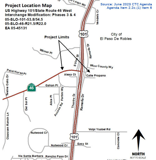 The 2018 STIP, approved at the CTC March 2018 meeting, appears to allocate $900K in Advance Project Development Element (APDE) funding for PS&E in FY21-22
for PPNO 2559 Rt 101/46W IC improvements, roundabouts. (~ SLO 54.096)
The 2018 STIP, approved at the CTC March 2018 meeting, appears to allocate $900K in Advance Project Development Element (APDE) funding for PS&E in FY21-22
for PPNO 2559 Rt 101/46W IC improvements, roundabouts. (~ SLO 54.096)
The 2020 STIP, approved at the CTC March 2020 meeting,
appears to continue the programmed funding for this project.
(Source: March 2020 CTC Agenda, Item 4.7, 2020 STIP
Adopted 3/25/2020)
In June 2023, the CTC approved for future consideration
of funding 05-SLO-101, PM 53.8/54.5 05-SLO-46, PM R21.5/R22.0. US 101/Route 46 West Interchange Modification Project. Interchange
improvements at the US 101 / Route 46 interchange, in San Luis Obispo
County. (MND and MND Addendum) (PPNO 2559) (STIP). The project is located
on US 101 at postmile 53.8 to postmile 54.5, and Route 46 at postmile
R21.5 to postmile R22.0, in San Luis Obispo County. The Department
proposes to improve the US 101/Route 46 west interchange. The project is
currently programmed in the 2020 STIP for a total of $19,109,000, which
includes $1,300,000 for the Plans, Specifications, and Estimates phase.
Construction began in 2020-21 The scope, as described for the preferred
alternative, is consistent with the project scope as programmed by the
Commission in the 2020 STIP. A copy of the MND and Addendum has been
provided to Commission staff. The project will result in less than
significant impacts to the environment after mitigation. The following
resource areas may be impacted by the project: aesthetic and biological
resources. Avoidance, minimization, and mitigation measures will reduce
any potential effects to the environment. These measures include, but are
not limited to, implementing a landscape and revegetation plan to address
affected oak trees and vegetation replanting or removal, replanting oak
trees at a 10:1 ratio, limiting project lighting to minimize light and
glare impacts, and aesthetic treatments to the wall along the south side
of SR 46 West and the retaining wall associated with the existing
drainage. As a result, a MND and addendum was completed for this project.
An Addendum was prepared to address changes in new regulations concerning
project analysis of air quality, energy, noise, traffic, and biology
(wetland jurisdiction requirements; as well as the status of listed
species). The project also incorporated a revised roundabout design, which
will create a modified Type L-1 interchange with two
single-circulating-lane roundabouts at the ramp intersections. The reduced
footprint of the revised project resulted in a smaller disturbance area
and will require less property acquisition than the original project
design. The Department subsequently completed an Addendum to the MND
pursuant to CEQA.
(Source: June 2023 CTC Agenda, Agenda Item 2.2c.(1) Item 6)
In June 2023, the CTC approved the following
locally-adminstered STIP allocation: $1,300,000. 05-SLO-46 R22/R22. PPNO
05-2559; ProjID 0520000170; EA 45131. Route 101/46 West Interchange
Improvement Phase 3. In Paso Robles, at the junction of Route 101
and Route 46 West. Reconfigure intersection of Route 101 southbound on-
and off- ramps. CEQA - MND, 06/01/2023. NEPA - FONSI, 06/01/2023. Time
extension for FY 21-22 PS&E expires June 30, 2023. Concurrent Future
Consideration of Funding under Resolution E-23-94; June 2023. Allocation:
PS&E $1,300,000.
(Source: June 2023 CTC Agenda, Agenda Item 2.5c.(2))
 Naming
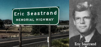 This segment is officially named the "Eric Seastrand Memorial Highway" (~ SLO R0.000 to SLO
R21.852). Named by Assembly Concurrent Resolution No. 22, Chapter 75, in
1993. Eric Seastrand served in the California State Assembly from 1983 to
1985, serving San Luis Obispo County, representing California's 22nd
District, home to Vandenberg Air Force Base. He was very active in the
establishment of the California Spaceport Authority.
This segment is officially named the "Eric Seastrand Memorial Highway" (~ SLO R0.000 to SLO
R21.852). Named by Assembly Concurrent Resolution No. 22, Chapter 75, in
1993. Eric Seastrand served in the California State Assembly from 1983 to
1985, serving San Luis Obispo County, representing California's 22nd
District, home to Vandenberg Air Force Base. He was very active in the
establishment of the California Spaceport Authority.
(Image source: One Voter Project, Join California)
 Scenic Route
 From Route 101 in Paso Robles to Route 99 near Famoso via
Cholame Pass.
From Route 101 in Paso Robles to Route 99 near Famoso via
Cholame Pass.
Post 1964 Signage HistoryAs defined in 1963, this segment ran from "Route 101 in San Luis Obispo County to Route 99 near Bakersfield via Cholame Pass." In 1965, Chapter 1371 changed the terminus to "Route 99 near Famoso via Cholame Pass." In 1992, Chapter 1243 made the origin more specific: "Route 101 in Paso Robles"
Route 46 is an important link in the State’s Interregional Road
System and is classified as a “Focus Route” and a “High
Emphasis Route.” This route has been deemed a State Highway
Extra Legal Load route and is included in the National Highway System.
This goods movement route is a critical east-west highway between US 101
and Interstate 5 (I-5) that connects the Central Coast and Central Valley
areas. As such, the interregional route carries a high truck volume,
accounting for approximately 20 percent of daily traffic, as well as
recreational travel to the coast.
(Source: October 2020 CTC Agenda, Agenda Item
2.3a.(2))
In October 2020, the CTC adopted a new route alignment near the Cholame
Wye. This is discussed in the STATUS section below. The purpose of the
project is to improve safety by reducing fatal collisions and to address
operational needs. The proposed improvements include: (1) widening Route 46 to a divided four lane expressway; (2) construction of a new
interchange at the Route 46/Route 41 junction; (3) replacement of the
Cholame Creek Bridge; (4) realignment to the northeast to correct
non-standard horizontal curvature to improve sight distance; (5) and
construction of Cholame Creek Overflow Bridge. The proposed interchange
also requires realignment of the existing Route 46/Route 41 junction to
the northeast to avoid sensitive environmental resources within Cholame
Valley. The interchange will provide direct branch connectors from
eastbound and westbound Route 46 to northbound Route 41 and from
southbound Route 41 to eastbound and westbound Route 46. This
interchange is also expected to improve traffic operations by eliminating
the left-turn movement from Route 46 to Route 41 and the subsequent
queuing. Route 41 was never adopted by the Commission and will
require approval of a route adoption action. The Department’s
recommendation to adopt Route 41 will be under a concurrent action under
Resolution HRA 20-03. The current programmed amount for the
construction of the Wye section is $97,800,000 funded by the 2021-2022
STIP. Right-of-way acquisition is currently estimated at $290,000.
Construction of the Wye section is expected to begin in 2023 and will
complete the entire SR 46 Corridor Improvements initiated in the 1990s.
The existing portions of Route 46 will be partially relinquished as local
roads. The remaining sections will be obliterated and
environmentally restored to its natural conditions before disposal of the
right-of-way as excess lands. SLO County has reviewed and concurred with
all proposed improvements. Relinquishment agreements will be executed
after the route adoptions are approved. On September 23, 2008, the
Department and the County of SLO entered into a Freeway Agreement
(FA) for the entire corridor of Route 46, from the Paso Robles city
limits to the Kern county line. A Superseding FA will be executed by the
Department after the Commission’s approval of the route adoption.
(Source: October 2020 CTC Agenda, Agenda Item
2.3a.(2))
Pre 1964 Signage History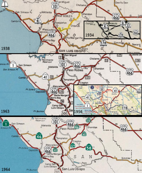
 Between the 1958 and 1964, this route (from Paso Robles to Shandon) was signed as US 466. It was LRN 33, and was defined in 1916. (Prior to 1958, US 466 was routed along LRN 125 although it was unsigned). US 466 was cosigned with Route 41 between
Shandon and Cholame. The portion between Route 101 and Shandon was
unimproved to Creston, and improved from Creston to Shandon. US 466
continued S from Route 99 in Bakersfield to the Nevada State Line, along
the routing of what is now Route 58 (LRN 58) to Barstow, and then N on US 91 (now I-15; LRN 31)
Between the 1958 and 1964, this route (from Paso Robles to Shandon) was signed as US 466. It was LRN 33, and was defined in 1916. (Prior to 1958, US 466 was routed along LRN 125 although it was unsigned). US 466 was cosigned with Route 41 between
Shandon and Cholame. The portion between Route 101 and Shandon was
unimproved to Creston, and improved from Creston to Shandon. US 466
continued S from Route 99 in Bakersfield to the Nevada State Line, along
the routing of what is now Route 58 (LRN 58) to Barstow, and then N on US 91 (now I-15; LRN 31)
Note: For the specific history of US 466,
see the page on US 466.
The Route 46 signage was not defined in 1934. It is likely that Route 46
was first signed in 1964 with the decommissioning of US 466, taking over
what had been Route 41 to Cambria, and former US 466 from Paso Robles to
points East. The route that became Route 46 was adopted into the
California Highway System in 1915 and was made part of the California
Freeway and Expressway System in 1971 as a Controlled Access Highway.
Within the county, this highway crosses terrain that transitions from
gently rolling rangeland to level agricultural land and small urban areas.
Route 46 has been designated as a State Highway Terminal Access Route for
larger trucks under the Federal Surface Transportation Act of 1982. Route 46, from its junction with Route 101 to its junction with I-5, is a State
Highway Extra Legal Load (SHELL) Route and is included in the National
Highway System. Route 46 is also a High Emphasis Interregional Route. The
route is designated for explosives, hazardous materials (including rocket
fuel), and trucks up to 105 feet in length. On a year-around basis, Route 46 is a significant interregional route for agricultural products, and
truck traffic accounts for 40% of the Average Annual Daily Traffic (AADT).
(H/T: Max R and the crew at AARoads for helping to sort some of this out.)
Between Paso Robles and Shandon, Route 46 was part of
the original 1934 signage of Route 41. In Paso Robles, 1934-1964 Route 41
multiplexed US 101 on Spring Street in downtown Paso Robles from 13th
Street southward. In 1957, construction was in progress on a new
expressway grade for 1934-1964 Route 41/LRN 33 (now Route 46) east of Paso
Robles towards Shandon. In 1958, completion of the Paso Robles Bypass for
US 101 shifted the alignment of US 466/US 101/Route 41 onto a new limited
access grade replacing Spring Street.
(Sources: Tom Fearer and the crew at AARoads; Gribblenation Blog “ Former US Route 101 and California State Route 41 through Paso
Robles” (Tom Fearer), June 2021)
In 1958, the Division of Highways sought and obtained permission to
relocate US 466 off of LRN 125 (today's Route 41) between Atascadero and
Shandon. The Division of Highways noted that Sign Route 41/LRN 33
between Paso Robles-Shandon had recently been improved and was by far the
favored highway for traffic. LRN 125 between Atascadero-Shandon was
substandard in design and despite being part of US 466 since 1933;
further, was never signed as US 466. US 101 through Paso Robles was also
receiving an upgrade to freeway at the time. The new alignment of US 466
would see it briefly multiplex Sign Route 41 west of Shandon to Paso
Robles via 24th Street and US 101 south to Atascadero via
Spring Street. Note that in 1964, Sign Route 41 W of Shandon to Paso
Robles (former post-1958 US 466) became Route 46, former Sign Route 41
from Paso Robles to Cambria became Route 46, and former US 466 from
Atascadero to Morro Bay became Route 41.
(Source: Gribblenation Blog, "The James Dean Memorial Junction interchange (California State Routes 41 and 46)", 6/8/2026)
By 1960, US 466/Sign Route 41 bypassed Shandon. The Cholame Valley
Y-junction where James Dean was killed was altered to soften the turnoff
for northbound Sign Route 41 towards Cottonwood Pass. US 466 over
Polonio Pass was relocated to a straightened alignment whereas the
original so-called Antelope Grade was abandoned. The Shandon Bypass
was accepted by the Division of Highways on November 6, 1959, whereas the
improvements to Polino Pass were complete during August 1959. In May 2017,
following a fatal accident at the junction of Route 41 and Route 46, San
Luis Obispo County began to explore funding methods to build a grade
separation. During March 2018, the CTC would award $197 million to
widen Route 46/Route 41 to a four-lane expressway in Cholame Valley along
with construction of a grade separation. The CTC would make a formal
alignment adoption during October 2020 following the corridor Final
Environmental Impact Report being completed. See the status section below
for more details on the conversion.
(Source: Gribblenation Blog, "The James Dean Memorial Junction interchange (California State Routes 41 and 46)", 6/8/2026)
In the area of Whitley Gardens (~ SLO 39.979), what would become Sign
Route 41 (today's Route 46), was part of a 1933 extension of LRN 33 to a
new terminus west of Paso Robles at LRN 56 in Cambria. It was signed as
Sign Route 41 in 1934. Sign Route 41 crossed the 1910 Estrella River
Bridge west of Shandon. From the river the highway followed Union
Road and 13th Street to US 101 at Spring Street in downtown
Paso Robles. As part of this routing, LRN 33 crossed the 1910 Estrella
River Bridge via what was called Shandon Road in 1919. In 1957, an
upcoming realignment of US 101/LRN 2 was announced on the Paso Robles
Bypass. The Paso Robles Bypass Project was 5.1 miles and would tie
into the existing divided highway segments on both ends of the city.
The Paso Robles Bypass Project included a tie-in with the recently
completed realignment of Route 41 from Huerhuero Creek east to the
Estrella River. Upon being bypassed, the road to the 1910
Estrella River Bridge came to be known as "River Grove Drive." Note that
this is distinct from the road named "Old SR 46".
(Source: Gribblenation Blog, "Former California State Route 41 over the 1910 Estrella River Bridge", October 2024)
The intersection of today's Route 41 and Route 46 has its origins in the
junction for the highways crossing Polonio Pass and Cottonwood Pass in the
Temblor Range. The so-called Lemoore Road departed Cholame Valley
heading northeast over Cottonwood Pass towards the shores of Tulare
Lake. The Polinio Pass Road departed the area eastward towards the
outskirts of Bakersfield. This junction dates back at least to 1915, when
it was appearing on maps. In 1916, Polonio Pass Road was adopted into the
State Highway System as LRN 33: [LRN 4] near Bakersfield to [LRN 2] near
San Luis Obispo County via Cholame Pass, and is today's Route 46 and was
US 466. LRN 33 was extended in 1933 from Paso Robles to Cambria; that
segment is today's Route 41. In 1933, Lemoore Road came under state
authority as LRN 125, a new State Highway between Morro Bay and the
southern boundary of Yosemite National Park. Today, the segment between
Morro Bay and Shandon is Route 41 (pre-1964 US 466), and the segment from
Cholame and Yosemite is Route 41.
(Source: Gribblenation Blog, "The James Dean Memorial Junction interchange (California State Routes 41 and 46)", 6/8/2026)
On June 14, 1948, the California Highway Commission (CHC) designated SR
46 between U.S. 101 and 1 mile east of the Estrella River as a
freeway. On June 21, 1955, November 15, 1955, and February 15, 1956,
the CHC designated certain sections of SR 46 between 1 mile east of the
Estrella River and the Kern County line as a freeway. SR 46 East is
designated an expressway and is on the California Freeway and Expressway
(F&E) system.
(Source: October 2020 CTC Agenda, Agenda Item
2.3a.(2); March 2024 CTC Agenda, Agenda Item 2.3a.(1))
StatusHighway 46 Corridor Project
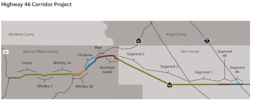 In December 2017, the Caltrans Mile Marker
published the following chart to show the progress of the various segments
of construction. It may prove useful for the discussion below:
In December 2017, the Caltrans Mile Marker
published the following chart to show the progress of the various segments
of construction. It may prove useful for the discussion below:
| Segment | Length (Mi) | Phase | Construction
Cost (Million) (* = Unfunded) |
|---|---|---|---|
| Union / PPNO 2528 | 5.0 | Completed 2010 | $33.3 |
| Whitley 1 | 4.0 | Completed 2014 | $47.0 |
| Whitley 2A / PPNO 0226G | 5.1 | Completed 2016 | $38.1 |
| Whitley 2B | 4.0 | Completed 2019 | $45.7 |
| Cholame / PPNO 0226J | 4.4 | Design / Right of Way | $55.0 |
| Wye / PPNO 0226K | 3.2 | Planned | $111.0* |
| Antelope Grade / PPNO 0226L | 3.1 | Planned | $43.2* |
| Segment 2 | 7.3 | Completed | $24.3 |
| Segment 3 | 12.5 | Completed | $45.3 |
| Segment 1 | 7.7 | Completed | $24.2 |
| Segment 4A | 3.0 | Design / Right of Way | $17.5 |
| Segment 4B | 3.0 | Planned | $50.0* |
Route 46 East/Union Road Intersection Improvements (05-SLO-46, PM 30.7/32.4)
 In June 2015, the CTC allocated $450,000 for the Route 46/Union Road
Intersection Improvements. This project is in Paso Robles, at the Route 46/Union Road Intersection (apx. SLO 35.009), and consists of construction
of intersection improvements, including new local roads and interchange.
In June 2015, the CTC allocated $450,000 for the Route 46/Union Road
Intersection Improvements. This project is in Paso Robles, at the Route 46/Union Road Intersection (apx. SLO 35.009), and consists of construction
of intersection improvements, including new local roads and interchange.
The 2018 STIP, approved at the CTC March 2018 meeting, appears to allocate $800K in Advance Project Development Element (APDE) funding for PS&E in FY19-20 for PPNO 2528 Rt 46/Union Road Intersection improvements.
The 2020 STIP, approved at the CTC March 2020 meeting,
continues the programmed allocations for PPNO 2528 "Rt 46/Union Road
Intersection improvements (APDE)"
(Source: March 2020 CTC Agenda, Item 4.7, 2020 STIP
Adopted 3/25/2020)
In July 2023, it was reported that Caltrans and the
City of Paso Robles propose to construct, in two phases, an overcrossing
and partial cloverleaf interchange at the intersection of Route 46 East
and Union Road/Paso Robles Boulevard. Caltrans and the city have completed
a draft initial study with the proposed mitigated negative
declaration/environmental assessment for the proposed Route 46 East/Union
Road intersection improvement project. They are now hosting public
meetings to review environmental assessment study results and gather
public input on the project.
(Source: Paso Robles Daily News, 7/27/2023)
In August 2023, it was reported that Paso Robles was
seeking community feedback on plans to build a bridge that goes over Route 46 East and connects Union Road/Paso Robles Boulevard. The joint project
between the city and Caltrans District 5 aims to improve the efficiency
and safety of Route 46 at Union Road for cars, buses, pedestrians and
cyclists. The 2022 STIP has the project budged for $1.55 million, a sum
the city is matching for a total cost of $3.1 million for the planning,
specifications and estimates phase of the project. More funding is
required to get the project through to the construction phase, according
to Caltrans. The first phase of the Route 46 and Union Road improvement
project involves building a bridge over Route 46 to connect the two city
streets. The overpass will include traffic lanes for the appropriate
volume of traffic, sidewalks for pedestrians and striped bike lanes
adjacent to and on the shoulders.
(Source: $$SLO Tribune, 8/18/2023)
In September 2024, it was reported that the City of
Paso Robles announced it is moving into the design phase of its
Intersection Improvements Project, a plan intended to improve traffic
conditions along Route 46. In 2009, Caltrans conducted a comprehensive
corridor study on Highway 46 between Golden Hill Road and an area just
east of Airport Road. They identified the intersection of Union Road and
Route 46 as a “high priority location for improvement” due to
limited access to both sides of the highway. In 2014, Caltrans and the
City of Paso Robles developed the Route 46 East Union Road Intersection
Improvements project, proposing to construct an overpass and partial
cloverleaf interchange at the Union Road and Route 46 intersection. Phase
1 of the project is estimated to cost $52 million and would include the
construction of the overpass, while Phase 2 is estimated to cost $118
million and focuses on the partial cloverleaf interchange. A construction
timeline has not yet been approved.
(Source: KSBY, 9/18/2024)
In October 2024, the CTC approved for future
consideration of funding 05-SLO-46, PM 30.7/32.4. State
Route 46 East/Union Road Intersection Improvements. Convert the
at-grade intersection of Route 46 East and Union Road/Paso Robles to a
grade-separated crossing, in San Luis Obispo County. (MND) (PPNO 2528)
(STIP). The project is located on Route 46 from PM 30.7 to PM 32.4, in San
Luis Obispo County. The Department proposes to construct, in two phases,
an overcrossing and partial cloverleaf interchange at the intersection of
Route 46 East and Union Road/Paso Robles Boulevard. The project is
currently programmed in the 2024 State Transportation Improvement Program
(STIP). The total programmed amount which includes Right of Way (Capital),
and Construction (Capital) is $65,000,000 from STIP and Regional
Improvement Program. Construction is estimated to begin in 2026-27. The
scope, as described for the preferred alternative, is consistent with the
project scope as programmed by the Commission in the 2024 STIP.
(Source: October 2024 CTC Agenda, Agenda Item 2.2c.(1) #8)
In October 2024, the CTC approved an allocation of
$1,550,000 for the locally-administered STIP Route 46/Union Road
Intersection Improvements project (PPNO 2528), on the State Highway
System, in San Luis Obispo County. 05-SLO-46 30.7/32.4. PPNO 05-2528;
ProjID 0512000070; EA 1C150. Route 46/Union Road Intersection
Improvements. In the City of El Paso de Robles, Construction
Interchange improvements. The project proposes construction of a new
interchange to improve safety, reduce delay and improve operations at a
vital intersection along Route 46 Corridor in Paso Robles, a primary
connector between I-5 and US 101. The proposed design will eliminate
left-turn movements at two at-grade intersections on the 4-lane
expressway, providing safer access to local roads for trucks and
commuters, as well as improving connectivity for bicycles and pedestrians.
CEQA - MND, 06/07/2024. NEPA - FONSI, 06/07/2024. Concurrent consideration
of funding under Resolution E-24-101; October 2024. Contribution from
other sources: $1,550,000. Time Extension for FY 22-23 PS&E
expires February 28, 2025. Allocation: PS&E $1,550,000.
(Source: October 2024 CTC Agenda, Agenda Item 2.5c.(5))
In March 2025, the CTC amended the STIP to: (a)
Deprogram $10,200,000 STIP-Regional Improvement Program (RIP) funds from
the CON phase of US 101-Prado Road Overcrossing and Northbound Ramp
Improvements project (PPNO 2831), and reprogram the funds as follows:
$5,730,000 for CON on the Bob Jones Trail Extension Segment 2 (PPNO 3060C)
and $3,200,000 for CON on Shell Beach Road Shared Use Path Extension
project (PPNO 3196); (b) Deprogram $6,000,000 from CON,on Route 46/Union
Road Intersection Improvements project (PPNO 2528) and program $2,800,000
to the Right of Way Capital; and (c) Program $2,850,000 for CON on Morro
Bay to Cayucos Multi-Use Trail Gap Closure project (PPNO 3124) adjacent to
Route 1.
(Source: March 2025 CTC Agenda, Agenda Item 2.1a.(2))
In March 2026, the CTC adopted the 2026 STIP, which
included the following as continued programming from 2024: PPNO 05-2528,
“Rt 46/Union Rd Intersect improvs (ext6-23)”. Total Programmed
($×1000): $1,550. Prior years programming ($×1000): $1,550. 2026
and Future Programming ($×1000): $0. Programming Breakdown
($×1000): $0 (PA&ED), $1,550 (PS&E), $0 (Const), $0 (Con
Sup), $0 (R/W), $0 (R/W Sup). The same PPNO had a second entry in the
table: PPNO 05-2528, “Rt 46/Union Rd Intersect improvs
(ext6-23)”. Total Programmed ($×1000): $2,800. Prior
years programming ($×1000): $2,800. 2026 and Future Programming
($×1000): $0. Programming Breakdown ($×1000): $0 (PA&ED), $0
(PS&E), $0 (Const), $0 (Con Sup), $2,800 (R/W), $0 (R/W Sup).
(Source: March 2026 CTC Agenda, Agenda Item 4.4; 2026 STIP Staff Recommendations Adopted 2/27/2026)
In December 2012, the CTC approved $4,300,000 to replace the Estrella River Bridge near Paso Robles as it was structurally deficient (approx SLO 40.01).
Whitley 1, 2A and 2B Segments near Shandon (SLO 37.025 to SLO 49.6)
The SAFETEA-LU act, enacted in August 2005 as the reauthorization of TEA-21, provided the following expenditures on or near this route:
In October 2015, the CTC approved $55,200K in funding for 05-SLO-46 46/50.2 Route 46 Corridor Improvements (Whitley 2B). Near Shandon, from 0.2 mile east of McMillan Canyon Road (SLO 45.683) to 0.4 mile west of Lucy Brown Road (SLO 50.152). (CEQA - EIR, 5/19/2006.) (NEPA - FONSI, 5/19/2006.) (Future Consideration of Funding approved under Resolution E-06-23; July 2006.)
In the December 2017 Mile Marker, Caltrans noted: "A five-mile widening of the highway near Shandon is now underway, and the $47 million project is expected to be complete by the end of 2018. Plans call for construction to the Cholame area. The projected $55 million project is expected to begin in late 2019."
In June 2019, it was reported that Caltrans has
completed a widening project on Route 46 East from McMillan Canyon Road to
Lucy Brown Road through Shandon (Whitley 2B). Before completing this
project, Caltrans had already widened sections of Route 46 and Route 41
near Paso Robles. The widening of Route 46 East from Almond Drive (SLO
40.555) to McMillan Canyon Road (SLO 45.683) was completed in 2016. The
widening of Route 46 East from Geneseo Road (SLO 37.025) to east of Almond
Drive (SLO 40.555) was done in 2014, and the widening of Route 46 from
Airport Road (SLO 32.116) to Geneseo Road (SLO 37.025) finished in 2010.
In total, the project cost about $47 million. Now that this widening
project is complete Caltrans will work on widening another five-mile
segment of Route 46 East from Shandon Rest Area to Cholame (Cholame) in
the spring of 2020.
(Source: KSBY, 6/27/2019)
Cholame Segment (05-SLO-46, PM 49.7/54.7)
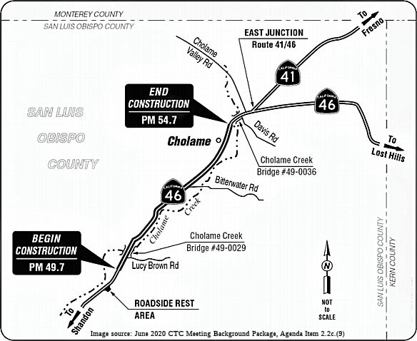 In June 2018, it was reported that concrete has started to flow for the new
Cholame Creek Bridge, west of the Shandon Roadside Rest Area (~ SLO
048.32). Subsuming as part of the bridge’s new permanent structure
the ‘lost deck,’ which had been visible to motorists until the
weekend, the new form should be ready to be stressed by the end of June.
The new infrastructure is expected to last 70 years. The
“stressing” will come in the form of cables running through
the structure pulled taught underneath, a design allowing for fewer ground
supports. It will be an improvement for the creek as there were three
supports before. With materials chosen for durability under heavy truck
traffic, the concrete slab roadway east leading up to the bridge is mostly
ready for connection, but drivers on the stretch are still using the
eventual westbound lanes to go both ways until that’s been done.
In June 2018, it was reported that concrete has started to flow for the new
Cholame Creek Bridge, west of the Shandon Roadside Rest Area (~ SLO
048.32). Subsuming as part of the bridge’s new permanent structure
the ‘lost deck,’ which had been visible to motorists until the
weekend, the new form should be ready to be stressed by the end of June.
The new infrastructure is expected to last 70 years. The
“stressing” will come in the form of cables running through
the structure pulled taught underneath, a design allowing for fewer ground
supports. It will be an improvement for the creek as there were three
supports before. With materials chosen for durability under heavy truck
traffic, the concrete slab roadway east leading up to the bridge is mostly
ready for connection, but drivers on the stretch are still using the
eventual westbound lanes to go both ways until that’s been done.
(Source: Paso Robles Press, 6/4/18)
The 2020 STIP, approved at the March 2020 CTC meeting,
included PPNO 0226J, Cholame, convert to 4-lane expressway, in the
Interregional portion of the STIP with one change in programming: $30,600K
in prior year funding (unchanged), and the $72,421K in FY20-21 changed to
93,955K.
(Source: March 2020 CTC Agenda, Item 4.7, 2020 STIP
Adopted 3/25/2020)
In June 2020, the CTC approved for future consideration
of funding 05-SLO-46, PM 49.7/54.7 Route 46 Corridor Improvement
Project. Widen the Cholame Section of Route 46 from a two-lane
highway to a four-lane divided expressway (PPNO 0226J). The project
proposes to construct the Choalame Section of the Route 46 Corridor
Improvement Project. As with the previously constructed sections of the
Corridor Project, the Choalame Section will continue with the conversion
of the existing two-lane highway to a four-lane divided expressway. This
project is fully funded and is currently programmed in the 2020 State
Transportation Improvement Program (STIP) for a total of $124,555,000
which includes Construction (capital and support) and Right of Way
(capital and support). Construction is estimated to begin in the fall of
2021. The scope, as described for the preferred alternative, is consistent
with the project scope programmed by the Commission in the 2020 STIP.
(Source: June 2020 CTC Agenda, Agenda Item
2.2c.(9))
In January 2022, the CTC approved the following request
for $124,220,000 (50.1 percent increase) allocation in Construction
Capital and $11,221,000 (0 percent increase) in Construction Support for
the STIP Roadway Widening project, on Route 46, in San Luis Obispo County.
(EA 3307A, PPNO 0226J). The project is located on Route 46, near Shandon,
from west of Shandon Safety Roadside Rest Area to east of Jack Ranch Cafe,
in San Luis Obispo County. The project will convert the two-lane
Conventional Highway into a four-lane Expressway. In March 2014, this
project was initially programmed in the STIP Interregional Improvement
Program for $46,000,000 in construction capital and $9,200,000 in
construction support for delivery in Fiscal Year 2018-19. In May
2016, the delivery was moved to Fiscal Year 2020-21. In October 2017,
during development of the 2018 STIP, the project was updated to follow a
new alignment to avoid major utility conflicts resulting in an increase of
$15,200,000 in construction capital and $2,021,000 in construction
support. In August 2019, during development of the 2020 STIP, the
scope of the project was updated due to increased earthwork, drainage
work, erosion control, and the addition of a Changeable Message Sign with
an increase of $21,534,000 in construction capital. In May 2021, the
project received a nine-month allocation time extension for construction
capital and construction support to reach RTL and complete the
Construction Management/General Contractor (CMGC) process.In November
2021, the Agreed to Price with the CMGC reflected the need of $124,220,000
in construction capital (50.1 percent over the programmed amount) and
$11,221,000 in construction support (same as programmed amount). The
Department plans to award the project in February 2022 and begin
construction in March 2022. Construction is planned for two
construction seasons with a duration of 514 working days. However, since
the end of 2020, prices on commodity goods and services have increased the
following
amounts. Fuel has increased more than 30 percent. Trucking has
increased 25 percent due to the fuel price and enforcement of recent
legislation for temporary workers. Ready Mix Concrete delivered to
the jobsite has increased more than 50 percent due to availability of
cement in the market and the cost of trucking. Reinforcing Steel has
increased 30 percent due to increased labor and trucking costs. The
2021 Stormwater General Construction Permit has increased the cost of
various stormwater items by 50 percent. In aggregate, these items amount
to an increase of $22,100,000 over the original engineering estimate.
(Source: January 2022 CTC Agenda, Agenda Item
2.5d.(1))
In April 2022, it was reported that Caltrans has broken
ground on the project that will double lanes along Route 46 in northern
San Luis Obispo County. The project will widen Route 46 East from Shandon
to Cholame. Construction on this phase is expected to wrap up sometime in
2024. At the end of the project, Route 46 East will be a four-lane
expressway from Paso Robles to Lost Hills in Kern County. The Cal Trans
Senior Engineer on the project is Amy Norris. She has been working
full-time in design at Cal Trans for over twenty years. “This is a
really unique project. We don’t often get to do this size earthwork
job anymore,” She said, “Being able to widen something like
this, and do 1.5 million cubic yards of dirt work- it’s pretty
exciting.” The widening of this segment of Route 46 East follows
four completed phases from Paso Robles leading to the Route 46/Route 41
intersection. The $47 million widening of Route 46 East from McMillan
Canyon Road to Lucy Brown Road was completed in 2019. The $38 million
widening from Almond Drive to McMillan Canyon Road was completed in 2016.
The widening of Route 46 East from Geneseo Road to east of Almond Drive
was completed in 2014 while the widening from Airport Road to Geneseo Road
was completed in 2010.
(Source: KSBY, 4/13/2022; Paso Robles Daily News, 4/18/2022)
In June 2024, the CTC approved for future consideration
of funding the following project for which a Final Environmental Impact
Report (FEIR) and Addenda have been completed: 05-SLO-46, PM 49.7/54.7. Route 46 Corridor Improvement Project – Cholame Segment. Convert
the existing two-lane highway to a four-lane divided expressway on Route 46, in San Luis Obispo County. (FEIR Addenda) (PPNO 0226J). The project
proposes to convert the existing two-lane highway to a four-lane divided
expressway on Route 46. Construction of the Cholame Segment would begin
approximately 0.2 miles east of the Shandon Roadside Rest Area and would
continue to approximately 0.5 miles west of the Route 41/Route 46
intersection. The project is currently programmed in the 2020 State
Transportation Improvement Program (STIP). The total programmed amount,
which includes Construction (Support and Capital) is $124,555,000 in STIP,
Interregional Improvement Program. Construction began in 2021-2022. The
scope, as described for the preferred alternative, is consistent with the
project scope as programmed by the Commission in the 2020 STIP. A copy of
the FEIR has been provided to Commission staff. The Commission approved
the project for future consideration of funding on June 24, 2020, under
Resolution E-20-54. Since the approval of the FEIR, there have been
changes to the project and Addenda were prepared pursuant to CEQA. These
changes include utility relocations, relocation of an access road, and
vegetation management on approximately 31 acres of private property to
address potential fire hazards. Vegetation management would be achieved
with prescribed burns by CalFire and mowing throughout construction. In
accordance with CEQA Guidelines Section 15162, no Subsequent FEIR is
required for the project because new information and changes in
circumstances, project description, impacts, and mitigation are not
substantial and do not involve new significant impacts or a substantial
increase in the severity of previously identified impacts. As a result,
the Department completed Addenda to the FEIR pursuant to CEQA.
(Source: June 2024 CTC Agenda, Agenda Item 2.2c.(2) #7)
In January 2025, the CTC approved a request for an
additional $1,800,000 (16.0% increase) in Construction Support for the
STIP Cholame project on Route 46, in San Luis Obispo County. (EA
3307A, PPNO 0226J) This project is located on Route 46 near Shandon, from
west of Shandon Safety Roadside Rest Area to east of Jack Ranch Cafe, in
San Luis Obispo County. The project will convert the two-lane
Conventional Highway into a four-lane Expressway. In March 2014, this
project was programmed in the STIP Interregional Improvement Program for
$46,000,000 in Construction Capital and $9,200,000 in Construction Support
for allocation in Fiscal Year 2018-19. In May 2016, the allocation
for the Construction phase was moved out to 2020-21. In October
2017, during development of the 2018 STIP, the project was updated to
follow a new alignment to avoid major utility conflicts and increased
Construction Capital to $61,200,000 and Construction Support to
$11,221,000. In August 2019, during development of the 2020 STIP,
the scope of the project was updated due to increased earthwork, drainage
work, erosion control, and the addition of a changeable message sign, and
increased Construction Capital to $82,734,000. In May 2021, the
project received a 9-month allocation time extension for the Construction
phase to reach RTL and complete the Construction Management/General
Contractor (CMGC) delivery process. In January 2022, the project was
allocated for $124,220,000 in Construction Capital and $11,221,000 in
Construction Support and awarded to the CMGC in February 2022. In
April 2022, construction began with 515 working days. In September
2024, the project received partial G-12 funds in the amount of $700,000 in
Construction Support. The project is 90 percent complete with 60
working days remaining. The remaining budget is $11,141,000 in
Construction Capital and $639,000 in Construction Support. The planned
Construction Contract Acceptance is February 2025. The project realized
support cost increases due to weather related work stoppage which resulted
in rework of the roadway and the need for consultant staff to administer
the project. During the 2023 rain year (October 2022 to September 2023),
the project location encountered severe rain which was well over the
normal amount. Storms began in early January 2023 and were
consistent through May 2023 which lengthened the winter suspension.
The contractor spent a couple of months recovering from the 2023 storms
which resulted in rework of the roadway subgrade for the eastbound
lanes. This rework required additional surveys, field inspection,
and material testing to return the project back to pre-storm
conditions. In addition, during the 2024 rain year (October 2023 to
September 2024), the project location again encountered severe rain which
was also over the normal amount. While this year was about half of
the rainfall compared to the previous year, the storms were consistent
which began in December 2023 and suspended work again through June
2024. The storms also resulted in additional rework by the
contractor and field inspection by the Department to bring the roadway
subgrade for the westbound lanes back to pre-storm conditions.
(Source: January 2025 CTC Agenda, Agenda Item 2.5e.(5))
In March 2026, the CTC adopted the 2026 STIP, which
included the following as continued programming from 2024: PPNO 05-0226J
(Interregional), “Cholame, convert to 4-lane exprsswy
(Supplemental)”. Total Programmed ($×1000): $1,800. Prior years
programming ($×1000): $1,800. 2026 and Future Programming
($×1000): $0. Programming Breakdown ($×1000): $0 (PA&ED), $0
(PS&E), $0 (Const), $1,800 (Con Sup), $0 (R/W), $0 (R/W Sup).
(Source: March 2026 CTC Agenda, Agenda Item 4.4; 2026 STIP Staff Recommendations Adopted 2/27/2026)
In March 2026, the CTC adopted the 2026 STIP, which
included the following as continued programming from 2024: PPNO 05-0226X
(Interregional), “Cholame landscape mitigation (split fr
226J)”. Total Programmed ($×1000): $333. Prior years
programming ($×1000): $333. 2026 and Future Programming
($×1000): $0. Programming Breakdown ($×1000): $0 (PA&ED),
$333 (PS&E), $0 (Const), $0 (Con Sup), $0 (R/W), $0 (R/W Sup).
(Source: March 2026 CTC Agenda, Agenda Item 4.4; 2026 STIP Staff Recommendations Adopted 2/27/2026)
Wye - Route 41/Route 46 Interchange (05-SLO-46, PM 54.0/57.8)
 In May 2017, it was reported that concern had arisen again regarding the
safety of Route 46, especially its interchange with Route 41. More than a
decade of efforts to widen the critical valley-coast link paid off in 2009
when construction started. The widening work has made the road safer,
giving drivers a swifter route around slow-moving semi-trucks, toy haulers
and RVs. But it hasn’t prevented accidents and deaths in the
shrinking section where the traffic still slides past on two side-by-side
lanes. Construction crews are working to close that gap and link the
finished widening projects in both counties. San Luis Obispo County
transportation planners are searching for money to improve the Antelope
grade and — just to the west — the infamous “Y”
intersection of Route 41 and Route 46. Jim Shivers, a spokesman for
Caltrans District 5, wrote in an email that road builders have been
fighting for years to widen Route 46 and eliminate the head-on or T-bone
collisions that can take such a high toll in lives. But there is only so
much money and the design, environmental and construction of the
improvements can only move at a certain pace. That’s why Caltrans
has installed lighted warning lights at the “Y” intersection
between Route 41 and Route 46 and added heavy rumble strips between the
two lanes of traffic to quickly remind drivers who drift across lanes to
get back on their side of the line, Shivers wrote. But even those efforts
can’t stop drivers from making mistakes or risky maneuvers like the
one that cost Villegas his life at the intersection of Route 41 and Route 46. [Which is why the ultimate solution is likely an appropriate
roundabout, if space permits - DPF] The final solution is to complete the
widening work on Route 46 between I-5 and US 101 in Paso Robles. Most of
the widening work in Kern County has been completed, taking four lanes of
asphalt east more than 27 miles from the San Luis Obispo County line to
within striking distance of I-5. The last 6-mile stretch from Brown
Material Road to I-5 has yet to be constructed but efforts to fund and
design it are underway. Construction on the San Luis Obispo side brings
the wider route closer to Kern County every day. Currently, heavy
equipment is working near the small community of Shandon. That phase of
the project will end just past the Shandon rest stop. According to Shiver,
work on the environmental review for the next phase, the 5 miles from the
rest stop to Jack’s Ranch Café, is ongoing with funding for the
work expected to be available in the 2020-21 fiscal year. After that, the
transportation agency will tackle the two final segments. They will
include construction of an interchange of some sort between Route 41 and
Route 46 — eliminating the traffic conflict that contributed to the
death of legendary actor James Dean in 1955 and Villegas earlier this
month. The final piece of the puzzle will be widening the road up the
Antelope Grade to the Kern County line.
In May 2017, it was reported that concern had arisen again regarding the
safety of Route 46, especially its interchange with Route 41. More than a
decade of efforts to widen the critical valley-coast link paid off in 2009
when construction started. The widening work has made the road safer,
giving drivers a swifter route around slow-moving semi-trucks, toy haulers
and RVs. But it hasn’t prevented accidents and deaths in the
shrinking section where the traffic still slides past on two side-by-side
lanes. Construction crews are working to close that gap and link the
finished widening projects in both counties. San Luis Obispo County
transportation planners are searching for money to improve the Antelope
grade and — just to the west — the infamous “Y”
intersection of Route 41 and Route 46. Jim Shivers, a spokesman for
Caltrans District 5, wrote in an email that road builders have been
fighting for years to widen Route 46 and eliminate the head-on or T-bone
collisions that can take such a high toll in lives. But there is only so
much money and the design, environmental and construction of the
improvements can only move at a certain pace. That’s why Caltrans
has installed lighted warning lights at the “Y” intersection
between Route 41 and Route 46 and added heavy rumble strips between the
two lanes of traffic to quickly remind drivers who drift across lanes to
get back on their side of the line, Shivers wrote. But even those efforts
can’t stop drivers from making mistakes or risky maneuvers like the
one that cost Villegas his life at the intersection of Route 41 and Route 46. [Which is why the ultimate solution is likely an appropriate
roundabout, if space permits - DPF] The final solution is to complete the
widening work on Route 46 between I-5 and US 101 in Paso Robles. Most of
the widening work in Kern County has been completed, taking four lanes of
asphalt east more than 27 miles from the San Luis Obispo County line to
within striking distance of I-5. The last 6-mile stretch from Brown
Material Road to I-5 has yet to be constructed but efforts to fund and
design it are underway. Construction on the San Luis Obispo side brings
the wider route closer to Kern County every day. Currently, heavy
equipment is working near the small community of Shandon. That phase of
the project will end just past the Shandon rest stop. According to Shiver,
work on the environmental review for the next phase, the 5 miles from the
rest stop to Jack’s Ranch Café, is ongoing with funding for the
work expected to be available in the 2020-21 fiscal year. After that, the
transportation agency will tackle the two final segments. They will
include construction of an interchange of some sort between Route 41 and
Route 46 — eliminating the traffic conflict that contributed to the
death of legendary actor James Dean in 1955 and Villegas earlier this
month. The final piece of the puzzle will be widening the road up the
Antelope Grade to the Kern County line.
(Source: Bakersfield.Com, 5/20/2017)
In March 2018, the CTC awarded $197 million for Route 46 improvements. The state money will allow his county's transportation
agency to continue widening Route 46, "including grade separation at the
Route 41 Wye intersection, our major connection between the Central Coast
and the valley." The Cholame Y area has been dubbed “Blood
Alley,” as it’s seen three times the number of motorist
fatalities than the state average, according to Caltrans. Plans call for
new interchange that would eliminate the need for northbound traffic to
cross Route 46 onto Route 41. The stretch of the highway has been a danger
zone for decades for motorists, who whiz by in opposite directions without
roadway separation.
(Source: San Luis Obispo Tribune, 3/23/2018)
The 2018 STIP, approved at the CTC March 2018 meeting, appears to allocate $2.5M in construction funding in FY21-22 for PPNO 0226K Route 46/Route 41 Wye, convert to 4-lane expressway.
The 2020 STIP, approved at the CTC March 2020 meeting,
continues the programmed allocation for PPNO 0226K "Route 46/41 Wye,
convert to 4-lane expressway (RIP)". It also included interregional
programming for PPNO 0226K: Route 46/41 Wye, convert to 4-lane expressway
(IIP), with one change: 25,000K in prior year funding changed to 35,000K,
and 108,700K in FY21-22 (unchanged).
(Source: March 2020 CTC Agenda, Item 4.7, 2020 STIP
Adopted 3/25/2020)
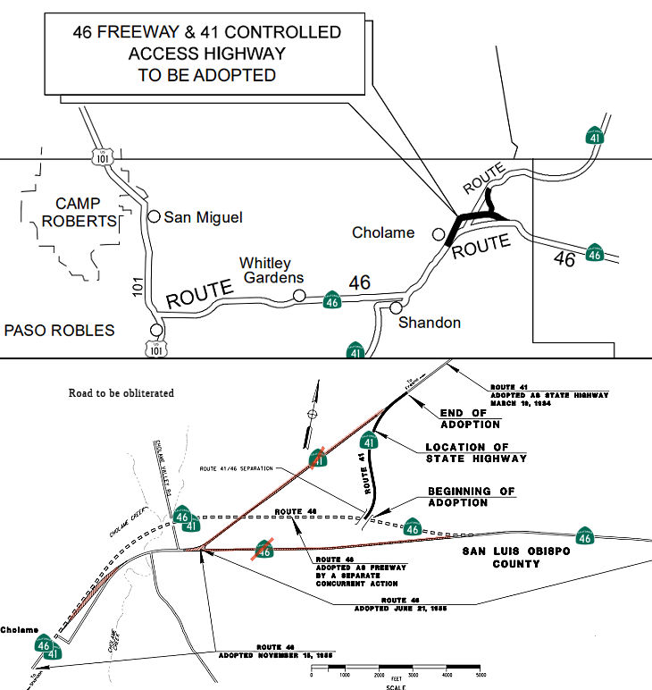
In October 2020, the CTC approved route adoption the
following project for which a Final Environmental Impact Report (FEIR) has
been completed: Route 46 in San Luis Obispo County. Construct a
four-lane, access controlled, divided expressway in San Luis Obispo
County. (PPNO 0226K) (05-SLO-46, PM 54.0/57.8) This project is located in
San Luis Obispo County on Route 46, beginning at post mile 54.0 and ending
at post mile 57.8. The CTC also approved a Route Adoption at the Wye
Section of the Route 46 Corridor Improvement Project. The purpose of this
project is to minimize fatal accidents, improve safety, and reduce
congestion on Route 46 between Paso Robles and Cholame, a critical
east-west corridor connecting the Central Coast and Central Valley. This
project is currently programmed in the 2020 State Transportation
Improvement Program (STIP) for $143,700,000 which includes Construction
(capital and support) and Right of Way (capital and support). Construction
is estimated to begin FY 2021-2022. The scope, as described for the
preferred alternative, is consistent with the project scope programmed by
the Commission in the 2020 STIP.
(Source: October 2020 CTC Agenda, Agenda Item
2.2c.(2))
The purpose of the project is to improve safety by
reducing fatal collisions and to address operational needs. The proposed
improvements include: (1) widening Route 46 to a divided four lane
expressway; (2) construction of a new interchange at the Route 46/Route 41
junction; (3) replacement of the Cholame Creek Bridge; (4) realignment to
the northeast to correct non-standard horizontal curvature to improve
sight distance; (5) and construction of Cholame Creek Overflow Bridge. The
proposed interchange also requires realignment of the existing Route 46/Route 41 junction to the northeast to avoid sensitive environmental
resources within Cholame Valley. The interchange will provide direct
branch connectors from eastbound and westbound Route 46 to northbound
Route 41 and from southbound Route 41 to eastbound and westbound Route 46. This interchange is also expected to improve traffic operations
by eliminating the left-turn movement from Route 46 to Route 41 and the
subsequent queuing. Route 41 was never adopted by the Commission and
will require approval of a route adoption action. The Department’s
recommendation to adopt Route 41 will be under a concurrent action under
Resolution HRA 20-03. The current programmed amount for the
construction of the Wye section is $97,800,000 funded by the 2021-2022
STIP. Right-of-way acquisition is currently estimated at $290,000.
Construction of the Wye section is expected to begin in 2023 and will
complete the entire SR 46 Corridor Improvements initiated in the 1990s.
The existing portions of Route 46 will be partially relinquished as local
roads. The remaining sections will be obliterated and
environmentally restored to its natural conditions before disposal of the
right-of-way as excess lands. SLO County has reviewed and concurred with
all proposed improvements. Relinquishment agreements will be executed
after the route adoptions are approved. On September 23, 2008, the
Department and the County of SLO entered into a Freeway Agreement
(FA) for the entire corridor of Route 46, from the Paso Robles city
limits to the Kern county line. A Superseding FA will be executed by the
Department after the Commission’s approval of the route adoption.
(Source: October 2020 CTC Agenda, Agenda Item
2.3a.(2))
In April 2022, it was reported that Caltrans the
project to improve the Route 46/Route 41 interchange is expected to begin
in 2024.
(Source: KSBY, 4/13/2022)
In December 2022, the CTC approved for future
consideration of funding the following project for which a FEIR and an
Addendum have been completed: Route 46 and Route 41 in San Luis Obispo
County (05-SLO-46, PM 54.0/57.8; 05-SLO-41, PM 44.5/45.3). Realign and
widen from two lanes to four lanes, on Route 46 and Route 41, in San Luis
Obispo County. (PPNO 05-0226K). This project is located on Route 46, at
post mile 54.0 and ending at post mile 57.8 and Route 41, at post mile
44.5 and 45.3, in San Luis Obispo County. The Department proposes a Route Adoption at the Wye Section of the Route 46 Corridor Improvement Project.
The purpose of this project is to minimize fatal accidents, improve
safety, and reduce congestion on Route 46 between Paso Robles and Cholame,
a critical east-west corridor connecting the Central Coast and Central
Valley. This project is currently programmed in the 2022 STIP for
$146,200,000 which includes Construction (capital and support) and Right
of Way (capital and support). Construction is estimated to begin in 2023.
The scope, as described for the preferred alternative, is consistent with
the project scope programmed by the Commission in the 2022 STIP. A FEIR
was prepared because of potential biological resource impacts. A copy of
the FEIR has been provided to Commission staff. The Commission approved
the project for future consideration of funding on October 22, 2020, under
Resolution E-20-100. Biological impacts would result from the construction
of the preferred alternative. This would require the acquisition and
disturbance of land throughout the entire length of the project. The
Department subsequently completed an Addendum to the FEIR pursuant to the
California Environmental Quality Act. The Department has approved this
project for construction. This approval and the Addendum satisfy the
environmental requirements for this stage of the planning process.
(Source: December 2022 CTC Agenda, Agenda Item
2.2c.(8))
In December 2022, the CTC approved a request for
$171,420,000, consisting of $155,870,000 (59.4% increase) allocation in
Construction Capital and $15,550,000 (16.0% increase) allocation in
Construction Support, for the STIP Roadway Widening project on Route 46,
in San Luis Obispo County. (05-SLO-46, PM 54.0/57.8; 05-SLO-41, PM
44.5/45.3) (PPNO 05-0226K, ProjID 0514000028, EA 3307C) . In March 2014,
the project was programmed in the STIP with $62,000,000 in Construction
Capital and $9,500,000 in Construction Support future need in Fiscal Year
2018-19. In March 2018, during development of the 2018 STIP, the
project was reprogrammed for $97,800,000 in Construction Capital,
$95,300,000 from the IIP and $2,500,000 from the RIP, and $13,400,000 in
Construction Support from the IIP. In June 2022, the project
received a 20-month allocation time extension for the Construction Capital
and Construction Support to complete the Construction Management/General
Contractor (CMGC) process after Ready to List was achieved. In October
2022, the Agreed to Price with the CMGC reflected the need of $155,870,000
in Construction Capital (59.4 percent over the programmed amount) and
$15,550,000 in Construction Support (16.0 percent over the programmed
amount). The Department plans to award the project in January 2023,
and begin construction in March 2023. Construction is planned for
three construction seasons with a duration of 500 working days. The
construction capital cost estimate is greater than the programmed amount
following the project’s refinement of the final design at Plans,
Specifications, and Estimate. During Fiscal Year 2019-20, the Department
elected to utilize the CMGC delivery method. The preconstruction
services contract was awarded to a contractor during the middle of
2020-21. The CMGC process identified several innovations as the Department
finalized the construction documents. Included in these innovations
were switching the pavement from continuously reinforced concrete to
asphalt concrete, utilizing existing Route 46 when allowable instead of
reconstructing near the eastern limits of the project, and optimizing
embankment settlement strategies. In total, the Department utilized
18 innovations developed by the Department’s Division of Design,
CMGC, and Independent Cost Estimator (ICE) consultant to reduce the
project costs by 28 percent (nearly $40,000,000). The Department
received a 20-month allocation time extension in June 2022, to allow for
the CMGC process to incorporate these innovations and allow flexibility to
reach an Agreed to Price with the contractor. As part of the CMGC
process, the Department also procured an ICE consultant, who works
directly for the Department, to ensure the prices from the CMGC contractor
are consistent with industry and the innovations proposed are feasible.
The three estimate results indicate the programmed amount for Construction
Capital costs were underestimated due to the escalation costs the market
has seen recently. The current cost estimate differs significantly from
the estimate used to validate the current programing for the
project. A major reason for this difference is trucking.
Material and equipment delivered to the work site or transported on site
are affected by the current higher trucking prices, so the impact is
widespread. A comparison of trucking cost increases since January
2021, which is when the programming could last be updated per STIP
guidelines, shows a 45.5 percent increase in hourly trucking rates.
Trucking represents about 10.9 percent of the total price on this project,
which is an increase of $5,240,000.
(Source: December 2022 CTC Agenda, Agenda Item
2.5d.(2))
In December 2022, Caltrans announced that the
California Transportation Commission had approved funding for the $171
million project reconfiguration of Route 46/Route 41 into a four-lane
expressway., which will break ground in March 2023 and take three years to
complete. The long-awaited upgrade will replace the dangerous Cholame
“Y” interchange with a flyover connection that routes
Fresno-bound traffic from Route 46 East to northbound Route 41. The
stretch of renovated road includes the location of Dean’s Sept. 30,
1955, fatal head-on collision, where his Porsche Spyder collided with
then-Cal Poly student Donald Turnupseed’s sedan turning left across
the roadway to Route 41. Once this project is complete, only one final
3.5-mile segment of Route 46 East along the Antelope Grade in San Luis
Obispo County to roughly half a mile within Kern County will remain to be
widened.
(Source: San Luis Obispo Tribune, 12/10/2022)
In April 2023, it was reported that Caltrans has broken
ground on the project to construct a new interchange at the Route 46/Route 41 "Y" in northern San Luis Obispo County. The project will also widen
nearly four miles of Route 46 to four lanes from west of Davis Road to
west of Antelope Road. This follows a project that has widened Route 46 in
multiple phases starting in Paso Robles. Eventually, Route 46 will be a
four-lane divided expressway from US 101 in Paso Robles to I-5 in Kern
County. The $148 million project is expected to take three years to
complete.
(Source: KSBY, 4/26/2023)
In January 2024, it was reported that construction on
this project has progressed to the point where a traffic switch onto a
segment of the newly constructed lanes is required. While construction
proceeds on the new eastbound lanes of the highway, traffic will be routed
onto the new alignment of what will eventually become the westbound lanes
of Route 46 East; this segment will include two-way travel from just east
of the Shandon Rest Area to just west of the Route 46/Route 41
“Wye” Interchange. Businesses will remain open during this
traffic shift. Travelers will maintain access to Bitterwater Road and the
Jack Ranch Café via a temporary driveway constructed just east of
Bitterwater Road. This temporary traffic shift is anticipated to be
in place until early summer 2024.
(Source: Paso Robles Press, 1/15/2024)
In June 2025, the CTC approved a request for an
additional $7,200,000 in Construction Support for the STIP Route 46/Route 41 Wye project on Route 41 and Route 46, in San Luis Obispo County, to
complete the construction contract. The project will convert 2-lane
conventional highway to a 4-lane expressway. This project has
utilized the Construction Management/General Contractor (CMGC) delivery
process. In March 2014, this project was programmed in the STIP for
$62,000,000 in Construction Capital and $9,500,000 in Construction Support
for allocation in Fiscal Year 2019-20. In March 2018, during the
adoption of the 2018 STIP, the project was updated to increase
Construction Capital to $97,800,000 and Construction Support to
$13,400,000. In June 2022, the project received a 20-month
allocation time extension for the Construction phase. In December
2022, the project was allocated for $155,870,000 in Construction Capital
and $15,550,000 in Construction Support. In March 2023, the project
was awarded to the CMGC for $155,869,900 in Construction Capital. In
April 2023, construction began with 500 working days. The project
has not received any G-12 funds for the Construction phase. The
remaining funds are currently at $50,700,000 in Construction Capital and
$2,429,000 in Construction Support. The project is 65 percent
complete with 230 working days remaining. The planned Construction
Contract Acceptance is June 2026. The project realized support cost
increases due to the need for additional Department and consultant staff
to administer the project, change in the construction method for
earthwork, material failure and rework of constructed items, change in the
construction schedule, and an increase in the number of working days to
complete the project. The project is located in a rural area which
required the Department to rely on consultant staff to administer the
contract and serve as field inspectors, office support staff, lab
technicians, and surveyors at the field office location. This
heavier reliance on consultant staff was unanticipated and resulted in a
significant cost increase from the original workplan. In addition, as a
result of environmental requirements and compliance issues, several
Department environmental staff are required to be on site two to three
times per week instead of one time per month. The project is located
in a region that is undeveloped and contains many important natural
resources and sensitive species. Permits for the project are complex
and require surveys and monitoring before, during, and after project
construction. Additional resources are required due to recent
listings of threatened species which require additional agency
consultations and ongoing discussions with adjacent landowners about
wildlife connectivity. In addition, an increase in nesting bird
activity requires additional monitoring and deterrence. The
Department’s roadway and structure design staff have also required
additional resources above what was anticipated to support the
construction staff for requests for information and issuance of contract
change orders.
(Source: June 2025 CTC Agenda, Agenda Item 2.5e.(6))
In June 2025, it was reported that on June 12,
Caltrans, local officials, and community members gathered near Cholame in
northern San Luis Obispo County to celebrate the completion of the Route 46 East and Route 41 interchange project. The new interchange includes a
flyover ramp that allows travelers to safely transition from eastbound
Route 46 to northbound Route 41. This grade-separated ramp enhances
traffic flow and improves safety for travelers at this major regional
intersection. The flyover ramp also includes transition ramps to westbound
and eastbound Route 46. Although the interchange officially opened to
traffic on June 12, travelers on Route 46 East will encounter two-way
traffic on the new westbound lanes near the interchange until the
eastbound lanes are completed later in Summer 2025. The interchange is
part of a larger phased project to widen Route 46 East from a two-lane
highway to a four-lane expressway, stretching from east of the Shandon
Rest Area to east of Davis Road. The first segment of widening began near
Paso Robles in 2008. The next phase of widening Route 46 East at the
Antelope Grade is expected to begin construction in spring 2027.
(Source: Paso Robles Daily News, 6/13/2025)
In March 2026, the CTC adopted the 2026 STIP, which
included the following as continued programming from 2024: PPNO 05-0226K
(Interregional), “Route 46/41 Wye, convert to 4-lane expressway
(IIP)(Supplmntl)”. Total Programmed ($×1000): $7,200. Prior
years programming ($×1000): $7,200. 2026 and Future Programming
($×1000): $0. Programming Breakdown ($×1000): $0 (PA&ED), $0
(PS&E), $0 (Const), $7,200 (Con Sup), $0 (R/W), $0 (R/W Sup).
(Source: March 2026 CTC Agenda, Agenda Item 4.4; 2026 STIP Staff Recommendations Adopted 2/27/2026)
Antelope Grade (05-SLO-46, PM 57.3/60.8, 05-Ker-46, PM 0.0/0.4)
 The 2020 STIP, approved at the March 2020 CTC meeting, included PPNO 0226L,
Route 46 Antelope Grade, convert to 4-lane expressway, in the
Interregional portion of the STIP with one change in programming: $15,494K
in FY21-22 reduced to 10,300K.
The 2020 STIP, approved at the March 2020 CTC meeting, included PPNO 0226L,
Route 46 Antelope Grade, convert to 4-lane expressway, in the
Interregional portion of the STIP with one change in programming: $15,494K
in FY21-22 reduced to 10,300K.
(Source: March 2020 CTC Agenda, Item 4.7, 2020 STIP
Adopted 3/25/2020)
In December 2021, it was reported that Antelope Grade
is the biggest challenge remaining along Route 46, and Caltrans has
earmarked $80 million to bypass it – $80 million it doesn’t
have yet. Former Congressman Bill Thomas to the rescue, perhaps.
That’s according to Ahron Hakimi of Kern Council of Governments, the
local transportation planning agency. Hakimi said he and Thomas are
meeting with top officials from Caltrans and neighboring counties to pitch
a $10 million interim solution – a widening project that Hakimi says
will pay for itself in safety.
(Source: KGET 17, 12/6/2021)
In August 2022, it was reported that Caltrans was
in the final phases of design for the Antelope Grade segment and was
conducing surveys to compile information from travelers and people in the
area.
(Source: KSBY 6 8/5/2022)
In September 2023, it was reported that Caltrans was
holding public meetings to discuss a proposal about converting a 3.6-mile
section of Route 46 East to a four-lane expressway in San Luis Obispo and
Kern Counties. The project will include modifications such as changes to
the highway alignment, avoiding high utility relocation costs, and
reducing the existing grade of the highway. According to Caltrans, the
Antelope Grade stretch sees the most volume of trucks on the central
coast. The steep grade makes it harder for larger trucks to speed up
causing bottleneck congestion. This phase of construction will include a
proposed bridge that will lessen the effect on the nearby creek and be
used as a wildlife crossing. Construction on the Antelope Grade Section is
expected to begin in 2027. Though the section is currently not funded the
estimated cost is $150 million.
(Source: KSBY, 10/2/2023)
In March 2024, the CTC approved for future
consideration of funding the following project for which a Subsequent
Mitigated Negative Declaration (MND) has been completed: State Route 46 Corridor Improvement Project Antelope Grade Segment (05-SLO-46,
PM 57.3/60.8, 05-Ker-46, PM 0.0/0.4; PPNO 05-0226L). The Department
proposes to convert a 3.6-mile portion of Route 46 to an expressway. The
project would construct a four-lane expressway with a 62-foot median on a
new alignment that roughly parallels the existing highway corridor to the
north. The project would also connect the existing four-lane expressway
section in Kern County with the four-lane expressway currently under
construction, the Wye segment, creating a continuous east-west corridor of
four-lane expressway from I-5 to US 101. The project is currently
programmed in the 2020 State Transportation Improvement Program (STIP).
The total programmed amount which includes Right of Way (Support and
Capital), and Construction (Support and Capital) is $101,300,000 from the
STIP, Interregional Improvement Program, SB 1 Trade Corridor Enhancement
Program, and Surface Transportation Program. Construction is estimated to
begin in Fiscal Year 2026-27. The scope, as described for the preferred
alternative, is consistent with the project scope as programmed by the
Commission in the 2020 STIP. A copy of the Subsequent MND has been
provided to Commission staff. The project will result in less than
significant impacts to the environment after mitigation. The following
resource areas may be impacted by the project: aesthetics/visual
resources, biological resources, and paleontological resources. Avoidance,
minimization, and mitigation measures will reduce any potential effects on
the environment. These measures include, but are not limited to,
preserving and revegetating native plants and habitat, and purchasing
off-site mitigation credits from an in-lieu fee program in accordance with
regulatory permits for impacts to jurisdictional waters, California Tiger
Salamander, and San Joaquin Kit Fox. In addition, the Principal
Paleontologist would be required to prepare a Paleontological Mitigation
Plan to minimize the potential for impacts to paleontological resources
during construction, and the Landscape Architect shall ensure that project
features are blended to match the natural landscape and setting to avoid
impacts to aesthetics/visual resources. On May 12, 2005, the
Department approved the MND for the San Luis Obispo and Kern Counties
Route 46 4-Lane Widening Project from PM 55.1 in San Luis Obispo County to
PM 33.5 in Kern County. This included three separate projects that covered
a 39.3-mile segment of Route 46. The majority of the two projects totaling
approximately 35.9 miles has been constructed by District 6, starting near
the Kern County line heading east toward the community of Lost Hills and
ending at I-5 at the West Side Canal. One remaining project, referred to
as Project 1 or the San Luis Obispo Project in the 2005 MND, was
reevaluated during the design phase and changes to the build alternative
were developed. The Antelope Grade North Alternative is now proposed to
avoid a known cultural site, reduce extraordinarily high utility
relocation costs associated with expanding the existing alignment, and
reduce the grade to increase the design speed to be consistent with the
surrounding segments. A Subsequent MND was determined to be the
appropriate environmental document pursuant to the California
Environmental Quality Act Guidelines Section 15162 due to substantial
changes of the proposed project. As a result, a Subsequent MND was
prepared for the project.
(Source: March 2024 CTC Agenda, Agenda Item 2.2c.(3))
 In March 2024, the CTC approved a controlled access
highway route adoption of Route 46 on a new alignment from 0.9 mile east
of Antelope Road to the Kern County line as part of the Route 46
Corridor Improvement Project - Antelope Grade Section that will
convert the existing two-lane highway to a four-lane divided expressway on
Route 46 from post mile 57.3 to post mile 0.4 (Antelope Grade Section) in
SLO and Kern Counties. The Department approved the Subsequent
Initial Study with Mitigated Negative Declaration / Updated Environmental
Assessment with Finding of No Significant Impact on January 2, 2024 and
the Supplemental Project Report (PR) on February 1, 2024. The realignment
is greater than 1,000 feet from the existing alignment of Route 46. There
are multiple reasons why the realignment is beneficial and necessary for
the project: 1) The realignment eliminates nonstandard horizontal curves
that are present on the existing alignment.; 2) The topography is
favorable to flatter grades approaching the mountain pass and provides
standard stopping sight distance on the vertical curves at the summit,
compared to the existing alignment. Improvements to the vertical
alignment will reduce the speed differential between trucks and other
vehicles and provide for more efficient freight movement.; 3) Route 46 is
realigned to the north to reduce and/or avoid conflicts with multiple oil
pipelines in the area. The relocation of pipelines is a very
expensive and time-consuming process, and the project will benefit by
reducing those conflicts. The proposed project and realignment have been
reviewed and discussed with SLO County staff and they have
concurred. The existing portions of SR 46 will be partially disposed
of through the right of way excess lands process, with the remainder to be
obliterated and restored to the natural ground condition as environmental
restoration before disposal of the right of way as excess lands. The
Department and the County of SLO entered into a Freeway Agreement for
Route 46 on September 23, 2008 for the entire portion of Route 46 from the
Paso Robles city limits to the Kern County line. A Superseding
Freeway Agreement or Controlled Access Highway Agreement will be executed
by the Department with the County of SLO after the Commission’s
approval of the controlled access highway route adoption.
In March 2024, the CTC approved a controlled access
highway route adoption of Route 46 on a new alignment from 0.9 mile east
of Antelope Road to the Kern County line as part of the Route 46
Corridor Improvement Project - Antelope Grade Section that will
convert the existing two-lane highway to a four-lane divided expressway on
Route 46 from post mile 57.3 to post mile 0.4 (Antelope Grade Section) in
SLO and Kern Counties. The Department approved the Subsequent
Initial Study with Mitigated Negative Declaration / Updated Environmental
Assessment with Finding of No Significant Impact on January 2, 2024 and
the Supplemental Project Report (PR) on February 1, 2024. The realignment
is greater than 1,000 feet from the existing alignment of Route 46. There
are multiple reasons why the realignment is beneficial and necessary for
the project: 1) The realignment eliminates nonstandard horizontal curves
that are present on the existing alignment.; 2) The topography is
favorable to flatter grades approaching the mountain pass and provides
standard stopping sight distance on the vertical curves at the summit,
compared to the existing alignment. Improvements to the vertical
alignment will reduce the speed differential between trucks and other
vehicles and provide for more efficient freight movement.; 3) Route 46 is
realigned to the north to reduce and/or avoid conflicts with multiple oil
pipelines in the area. The relocation of pipelines is a very
expensive and time-consuming process, and the project will benefit by
reducing those conflicts. The proposed project and realignment have been
reviewed and discussed with SLO County staff and they have
concurred. The existing portions of SR 46 will be partially disposed
of through the right of way excess lands process, with the remainder to be
obliterated and restored to the natural ground condition as environmental
restoration before disposal of the right of way as excess lands. The
Department and the County of SLO entered into a Freeway Agreement for
Route 46 on September 23, 2008 for the entire portion of Route 46 from the
Paso Robles city limits to the Kern County line. A Superseding
Freeway Agreement or Controlled Access Highway Agreement will be executed
by the Department with the County of SLO after the Commission’s
approval of the controlled access highway route adoption.
(Source: March 2024 CTC Agenda, Agenda Item 2.3a.(1))
In March 2024, the CTC approved a
request for $19,700,000 (233.9% increase) allocation in Right of Way
Capital and $2,541,000 (81.5% increase) allocation in Right of Way
Support, for: 05-SLO-46 57.3/60.8. PPNO 05-0226L; ProjID 0518000075; EA
3307E. SR 46 Expressway Conversion - Antelope Grade Segment. On
Route 46, in San Luis Obispo County near Cholame from east of Route 46/Route 41 Intersection east to Kern County Line. Convert existing 2-lane
conventional highway to 4- lane divided expressway. CEQA - MND, 01/02/2024
NEPA - FONSI, 01/02/2024 Concurrent consideration of funding under
Resolution E-24-20; March 2024. Contribution from other sources:
$1,700,000. Time extension for FY 21-22 RW expires March 31, 2024.
Concurrent programming of $1,270,00 in STIP-RIP funds for the RW phase
under Resolution G-24-29; March 2024. Allocation: R/W Sup $1,400,000
$2,541,000; R/W $5,900,000 $19,700,000.
The RW Capital and Support estimates are greater than the programmed
amount due to project impacts to right of way acquisition, environmental
mitigation, and utility relocation. In March 2018, this project was
programmed in the STIP and continued with the original selected
alternative to convert the existing two-lane conventional highway to a
four-lane divided expressway utilizing two lanes on the existing
alignment. The presence of two 8-inch fully cased oil lines and a
water line on the eastern limits of the project significantly increased
the cost of utility relocation from the original estimates in 2012.
The cost of land acquisition, environmental mitigation, and title and
escrow was slightly reduced from the initial estimate. In June 2020, after
the Design team redesigned the eastern 2.6 miles of the project and
changed the alignment to pass through an adjacent valley, the RW Capital
cost estimates were updated from 2018 using known costs from adjacent
corridor projects. These updated estimates coincided with the TCEP
Cycle 2 funding application. The change in the alignment resulted in
the estimate for utility relocation to be significantly reduced. The
costs for land acquisition, environmental mitigation, and title and escrow
remained mostly unchanged. In June 2023, the Department’s Roadway
Design, Landscape Architecture, and Environmental Analysis groups
collaborated to refine the new alignment to minimize project impacts to
right of way acquisition, environmental mitigation, and utility relocation
as a part of the subsequent draft Mitigated Negative Declaration and
Supplemental Project Report. In August 2023, a new right of way data
sheet provided a revised estimate. The project is in an area that
has sensitive species. Since their habitat will be impacted,
mitigation credits will have to be purchased. The addition of
California Tiger Salamander (CTS) habitat mitigation bank credits led to a
significant increase to the cost of environmental mitigation and was not
anticipated during the June 2020 update. Cost estimates for right of
way acquisition, and title and escrow are similar to previous data
sheets. The utility relocation cost had an increase due to
escalation. The project was originally programmed with RW Support from the
STIP to address the presence of two 8-inch fully cased oil lines along the
entire length of the project, a water line on the eastern limits of the
project, as well as land acquisition, environmental mitigation, and title
and escrow. The project was programmed with estimated RW Support
costs of $2,170,000. In June 2020, after the Design team redesigned the
eastern 2.6 miles of the project and changed the alignment to pass through
an adjacent valley, the RW Support cost estimates were reduced from the
2018 programming based on less anticipated utility coordination.
These updated estimates also coincided with the TCEP Cycle 2 funding
application and were based on expected impacts from the widening project.
In August 2023, impacts to CTS were identified, resulting in an extensive
collaboration effort that included Right of Way staff to determine if the
project team could reduce impacts. Furthermore, the CTS impacts will
now require the project to find and purchase credits from an offsite
mitigation bank not previously anticipated. In August 2023, a new
right of way data sheet provided a revised estimate. The realignment of
the eastern end of the project that will reduce the impacts to the CTS
habitat will also require additional utility coordination not previously
anticipated in this area. The RW Support cost is based on the
workplan that was updated in December 2023.
(Source: March 2024 CTC Agenda, Agenda Item 2.5s.(10))
In March 2026, the CTC adopted the 2026 STIP, which
included the following as continued programming from 2024: PPNO 05-0226L,
“Route 46 Antelope Grade, convert to 4-lane expressway
(TCEP/RIP)”. Total Programmed ($×1000): $1,270. Prior years
programming ($×1000): $1,270. 2026 and Future Programming
($×1000): $0. Programming Breakdown ($×1000): $0 (PA&ED), $0
(PS&E), $0 (Const), $0 (Con Sup), $1,270 (R/W), $0 (R/W Sup).
(Source: March 2026 CTC Agenda, Agenda Item 4.4; 2026 STIP Staff Recommendations Adopted 2/27/2026)
In March 2026, the CTC adopted the 2026 STIP, which
included the following as continued programming from 2024: PPNO 05-0226L
(Interregional), “Route 46 Antelope Grade, convert to 4-lane
expressway (TCEP)(IIP)”. Total Programmed ($×1000): $10,300.
Prior years programming ($×1000): $10,300. 2026 and Future
Programming ($×1000): $0. Programming Breakdown ($×1000): $0
(PA&ED), $10,300 (PS&E), $0 (Const), $0 (Con Sup), $0 (R/W), $0
(R/W Sup).
(Source: March 2026 CTC Agenda, Agenda Item 4.4; 2026 STIP Staff Recommendations Adopted 2/27/2026)
In March 2026, the CTC adopted the 2026 STIP, which
included the following as continued programming from 2024: PPNO 05-0226M
(Interregional), “Rt 46 Convert Expwy, Antelope Grade Child Seg1
(splt fr 0266L)(RIP,TCEP,CMGC)”. Total Programmed ($×1000): $35,920
$47,990. Prior years programming ($×1000): $0. 2026 and
Future Programming ($×1000): $35,920 $47,990
FY26-27. Programming Breakdown ($×1000): $0 (PA&ED), $0
(PS&E), $30,000 $40,000 (Const), $5,920
$7,990 (Con Sup), $0 (R/W), $0 (R/W Sup).
(Source: March 2026 CTC Agenda, Agenda Item 4.4; 2026 STIP Staff Recommendations Adopted 2/27/2026)
In March 2026, the CTC adopted the 2026 STIP, which
included the following as new programming: PPNO 05-0226N, “Rt 46
Antelope Grade, to 4-lane expressway (TCEP), Seg 2” (05-SLO-46,
57.3/60.8). Total Programmed ($×1000): $2,000. 2026 and Future
Programming ($×1000): $2,000 FY30-31. Programming Breakdown
($×1000): $0 (PA&ED), $0 (PS&E), $2,000 (Const), $0 (Con
Sup), $0 (R/W), $0 (R/W Sup).
(Source: March 2026 CTC Agenda, Agenda Item 4.4; 2026 STIP Staff Recommendations Adopted 2/27/2026)
Antelope Grade Truck Climbing Lanes (05-SLO-46 59.8/60.8)
 In May 2023, the CTC was noticed of an amendment that
would move COVID Regional Improvement Funds to program funding on the
following project: Antelope Grade Truck Climbing Lane Extension.
PPNO 05-3178; EA 1Q030. 05-SLO-46 59.8/60.8. On Route 46 from 1.0 mile
west of Kern Co. Line to 0.9 mile east of Kern Co. line. Construct
extension to existing truck climbing lane. Programmed funding: CON
In May 2023, the CTC was noticed of an amendment that
would move COVID Regional Improvement Funds to program funding on the
following project: Antelope Grade Truck Climbing Lane Extension.
PPNO 05-3178; EA 1Q030. 05-SLO-46 59.8/60.8. On Route 46 from 1.0 mile
west of Kern Co. Line to 0.9 mile east of Kern Co. line. Construct
extension to existing truck climbing lane. Programmed funding: CON $1,450K
$1,056K PA&ED 200 PS&E 200. This movement of funds was
approved in June 2023.
(Source: May 2023 CTC Agenda, Agenda Item 2.1b.(1); June 2023 CTC
Agenda, Agenda Item 2.1a.(3))
In January 2025, the CTC approved for future
consideration of funding the Antelope Grade Vertical Curve Correction
and Truck Climbing Lane Extension Project project for which a
Negative Declaration (ND) has been completed: The project is located on
Route 46 (PPNO 3660 and PPNO 3178; 05-SLO-46, PM 59.8/60.9; 05-Ker-46, PM
0.0/0.9) , where Caltrans proposes to extend the existing westbound truck
climbing lane and correct a vertical curve along Route 46 from PM 59.8 to
60.9 in San Luis Obispo County and PM 0.0 to 0.9 in Kern County. The SHOPP
Minor-A project EA 05-1Q030 is proposing to improve the vertical crest
curve at the San Luis Obispo and Kern County line. The Kern Council of
Governments State Transportation Improvement Program (STIP) project EA
05-1Q031 is proposing to extend the truck climbing lane. Both projects, EA
05-1Q030 and 05-1Q031 will be combined for construction under EA 05-1Q03U.
The project EA 05-1Q030 is currently programmed in the 2024 SHOPP. The
total programmed amount which includes Right of Way (Support and Capital),
and Construction (Support and Capital) is $8,184,000. The project EA
05-1Q031 is currently programmed in the 2022 STIP. The total programmed
amount, which includes Construction (Capital and Support) is $2,332,000 in
STIP, Regional Improvement Program. Construction will begin in 2024-25.
The scope, as described for the preferred alternative, is consistent with
the project scope as programmed by the Commission in the 2024 SHOPP and
2022 STIP..
(Source: January 2025 CTC Agenda, Agenda Item 2.2c.(1) #3)
TCRP Project #113 Route 46 Expressway (KER 0.4 to apx. KER 32.482) (Lost Hills)
The SAFETEA-LU act, enacted in August 2005 as the reauthorization of TEA-21, provided the following expenditures on or near this route:
With respect to HPP #3637, the CTC had on its October 2006 agenda a resolution that proposed to approve the project for future consideration of funding. This project in Kern and San Luis Obispo Counties is to construct a 4-lane expressway. This project is fully funded in the 2006 State Transportation Improvement Program (STIP) for $72,500,000 for capital and support. Construction is estimated to begin in Fiscal Year (FY) 2007-2008. A negative EIR was completed in October 2006.
![[TCRP 113]](https://www.cahighways.org/maps/046-trcp-113.jpg) There is currently a push to make a segment of the route a four-lane expressway.
Initial plans are for the expressway portion to run from US 101 to I-5,
but the expressway may be extended as far as Route 99. TCRP Project #113
will widen this to four lanes for 33 miles from I-5 to the San Luis Obispo
County line in Kern County. The overall project is to convert the existing
Route 46 from a two-lane conventional highway to a four-lane expressway
from Route 5 to the San Luis Obispo County line. The project also includes
pavement rehabilitation and improves traffic operations and traffic
safety. For delivery and implementation purposes, the project is separated
into four segments. The environmental document for the entire corridor was
completed in June 2005. The environmental document was delayed due to
receiving the Biological Opinion from United States Fish and Wildlife
Services in April 2005. Two of the segments are ready to begin
right-of-way acquisition. In October 2006, funds were requested from the
CTC for this purpose. The project is projected to be completed in FY
2016/2017. In 2007, funding was requested from the Corridor Mobility
Improvement Account. The construction of a four-lane expway from Geneseo
to Almond (Whitley 1) [$105,000K total cost; $67,742K requested and
recommended] was approved, but other corridor improvements (Whitley 2)
[$94,000K requested] were not recommended. The CMIA was also recommended
to fund widening of Route 46 to four-lanes between Kecks Rd and Route 33
($49.9 milllion requested, $45 million approved, total cost $94.195
million). The first request for bids (for the segment from Airport Road To
Geneseo Road was put out for bid in November 2007, with an estimate of
$39M. In July 2010, the second segment (from 0.5 Mile West Of Geneseo Road
To 0.6 Mile East Of Almond Drive) was put out for bid with an estimate of
$51M. In Spring 2012, the segment from 0.1 Mile east of Almond Drive to
0.8 mile east of Mcmillan Canyon Road was put out for bid. In August 2012,
the CTC reduced the original CMIA allocation for construction by
$1,912,000, from $40,000,000 to $38,088,000, for the Route 46 Corridor
Improvements (Whitley 2A) project (PPNO 0226G) in San Luis Obispo County,
reflecting award savings.
There is currently a push to make a segment of the route a four-lane expressway.
Initial plans are for the expressway portion to run from US 101 to I-5,
but the expressway may be extended as far as Route 99. TCRP Project #113
will widen this to four lanes for 33 miles from I-5 to the San Luis Obispo
County line in Kern County. The overall project is to convert the existing
Route 46 from a two-lane conventional highway to a four-lane expressway
from Route 5 to the San Luis Obispo County line. The project also includes
pavement rehabilitation and improves traffic operations and traffic
safety. For delivery and implementation purposes, the project is separated
into four segments. The environmental document for the entire corridor was
completed in June 2005. The environmental document was delayed due to
receiving the Biological Opinion from United States Fish and Wildlife
Services in April 2005. Two of the segments are ready to begin
right-of-way acquisition. In October 2006, funds were requested from the
CTC for this purpose. The project is projected to be completed in FY
2016/2017. In 2007, funding was requested from the Corridor Mobility
Improvement Account. The construction of a four-lane expway from Geneseo
to Almond (Whitley 1) [$105,000K total cost; $67,742K requested and
recommended] was approved, but other corridor improvements (Whitley 2)
[$94,000K requested] were not recommended. The CMIA was also recommended
to fund widening of Route 46 to four-lanes between Kecks Rd and Route 33
($49.9 milllion requested, $45 million approved, total cost $94.195
million). The first request for bids (for the segment from Airport Road To
Geneseo Road was put out for bid in November 2007, with an estimate of
$39M. In July 2010, the second segment (from 0.5 Mile West Of Geneseo Road
To 0.6 Mile East Of Almond Drive) was put out for bid with an estimate of
$51M. In Spring 2012, the segment from 0.1 Mile east of Almond Drive to
0.8 mile east of Mcmillan Canyon Road was put out for bid. In August 2012,
the CTC reduced the original CMIA allocation for construction by
$1,912,000, from $40,000,000 to $38,088,000, for the Route 46 Corridor
Improvements (Whitley 2A) project (PPNO 0226G) in San Luis Obispo County,
reflecting award savings.
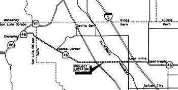 In January 2007, the CTC considered a route adoption of 29.9 miles of Route 46 near
the City of Lost Hills in the County of Kern as a Controlled Access
Highway. This route adoption extends the limits of the 1971 adoption from
PM 28.5 to PM29.9. The purpose of this project is to improve traffic
operations, improve traffic safety, and correct any deficiencies in the
existing roadway in order to meet all current design standards for a
four-lane expressway with a standard 62-feet median in most places. The
project improvements extend beyond the limits of the route adoption to 0.9
miles east of I-5. The proposed improvements include new lanes that will
shift north and south from the existing alignment in order to avoid a
natural creek, a canal, orchards and development along Route 46. The
design speed within the expressway limits would be upgraded to 80 miles
per hour and the existing roadbed would be rehabilitated to meet all
current design standards. Within the community of Lost Hills (PM 29.9 to
30.8), a four-lane conventional highway is proposed with an 18-foot
median. The median will act as a two way left turn lane. At I-5 and the
business district, the 30-foot median will consist of a left turn lane in
each direction separated by a curbed island. Several local roads and Route 33 will be realigned to provide a 90-degree approach to Route 46. This
will improve the safety and the operations of these intersections. Route 33 will be constructed with exclusive right and left turn lanes, and
storage for left turning movements. In addition, existing intersections
within the project limits will be upgraded to accommodate Surface
Transportation Assistance Act of 1982 trucks, which are roughly 69 feet
long. Within the limits of the route adoption, one bridge will be
replaced-the Bitter Water Creek Bridge (№ 50-437). Beyond the area
of the route adoption, new structures include the California Aqueduct
Bridge (№ 50-197), the Route 46/I-5 separation Bridge (№
50-316), the Main Flood Canal Bridge (№ 50-30), and the West Side
Canal Bridge (№50-29).
In January 2007, the CTC considered a route adoption of 29.9 miles of Route 46 near
the City of Lost Hills in the County of Kern as a Controlled Access
Highway. This route adoption extends the limits of the 1971 adoption from
PM 28.5 to PM29.9. The purpose of this project is to improve traffic
operations, improve traffic safety, and correct any deficiencies in the
existing roadway in order to meet all current design standards for a
four-lane expressway with a standard 62-feet median in most places. The
project improvements extend beyond the limits of the route adoption to 0.9
miles east of I-5. The proposed improvements include new lanes that will
shift north and south from the existing alignment in order to avoid a
natural creek, a canal, orchards and development along Route 46. The
design speed within the expressway limits would be upgraded to 80 miles
per hour and the existing roadbed would be rehabilitated to meet all
current design standards. Within the community of Lost Hills (PM 29.9 to
30.8), a four-lane conventional highway is proposed with an 18-foot
median. The median will act as a two way left turn lane. At I-5 and the
business district, the 30-foot median will consist of a left turn lane in
each direction separated by a curbed island. Several local roads and Route 33 will be realigned to provide a 90-degree approach to Route 46. This
will improve the safety and the operations of these intersections. Route 33 will be constructed with exclusive right and left turn lanes, and
storage for left turning movements. In addition, existing intersections
within the project limits will be upgraded to accommodate Surface
Transportation Assistance Act of 1982 trucks, which are roughly 69 feet
long. Within the limits of the route adoption, one bridge will be
replaced-the Bitter Water Creek Bridge (№ 50-437). Beyond the area
of the route adoption, new structures include the California Aqueduct
Bridge (№ 50-197), the Route 46/I-5 separation Bridge (№
50-316), the Main Flood Canal Bridge (№ 50-30), and the West Side
Canal Bridge (№50-29).
The CTC considered a funding adjustment to the Route 46 Expressway — Segment 3 Project (PPNO 3386A) in June 2008. This project converts the existing two-lane highway on Route 46 to a four-lane expressway from post mile (PM) 6.8 to PM 19.8. This project will also correct any deficiencies in the existing roadway in order to meet current design standards. This project is a vital segment in converting the Route 46 corridor to four lanes between I-5 in Kern County and Route 101 in San Luis Obispo County.
In March 2009, the CTC was noticed that in April there would be a STIP amendment regarding the expressway. The overall project is to convert Route 46 from a two-lane conventional highway to a four-lane expressway from the San Luis Obispo/Kern County line to Route 5. The Route 46 corridor in Kern County comprises the following four segments, which together compose Traffic Congestion Relief Program (TCRP) Project 113:
The proposed STIP amendment will fully fund construction of Segments 1 and 2 without the use of TCRP funding, which will allow the remaining TCRP funding ($22,430,000) to be programmed to Segment 4 in the future. It will also account for cost estimate changes on several Segment 1 and 2 components, as well as for the difference between the federal apportionment and the obligation authority for Demo funding on Segments 1 and 2.
In September 2010, the CTC received notice of a proposal to amend the 2010 State Transportation Improvement Program (STIP) to revise the funding plan for the Route 46 Expressway — Segment 4 project (PPNO 3386B) [in Wasco, from E of Browns Materials Road to I-5, conversion to a 4-lane expressway], reduce the programming for KCOG’s Planning, Programming and Monitoring (PPNO 6L03), and program two new projects, the 7th Standard Road 8-Lane project (PPNO 6267) [in Bakersfield, from Route 204 to 0.6 mi N of 7th Standard Road, which would widen the freeway from 6 to 8 lanes] and the Taft Highway 8-Lane project (PPNO 6268) [in Bakersfield from Route 119 to Wilson Road, widening the freeway from 6 to 8 lanes].
In September 2012, Caltrans held a groundbreaking ceremony today for the third phase of the $45 million Route 46 widening project, which will widen five miles of the highway from one to two lanes in each direction. Proposition 1B, the transportation bond approved by voters in 2006, is fully-funding this project. Phase one between Airport Road and Geneseo Road was completed in 2011 while work is currently underway on phase two of widening Route 46 from Geneseo Road to east of Almond Drive. Construction is expected to be completed in early 2013. Phase three will widen the highway from Almond Drive to McMillan Canyon Road.
In January 2013, the Kern County COG reported that two
of three segments along Route 46 from the Kern County line to just west of
I-5 that began widening construction in 2009-10 were complete and open to
the public. The two-lane highway west of I-5 in Kern County will be a
four-lane divided highway once Segment 3 is completed. Segment 1 (7.7
miles in length) and segment 2 (7.3 miles) were opened in late 2011.
Segment 3 is 12 miles long and scheduled for completion by September 2014
but could be delivered up to one year early, which would allow the
traveling public to traverse the new 27-mile 4-lane highway as soon as the
summer of 2013. Construction bids for all segments have totaled nearly
$100 million in federal, state and local funds.
(Source: Kern COG Winter 2012 Newsletter)
In June 2017, the TCRP #113 Route 46 Widening project received an infusion of the $26,372,000 in TCRP funds from program savings (on routes such as Route 132, Route 10, and Route 65, as well as projects off the state highway system). The overall project is being delivered in four segments: Segment 1 (PPNO 3386), Segment 2 (PPNO 3380A), Segment 3 (PPNO 3386A) and Segment 4A (PPNO 3386C). Segment 4 split into 4A and 4B. Segments 1, 2, and 3 are complete and open to traffic. Segment 4B is currently unfunded. Although design of Segment 4A is completed and a request for concurrent allocation for construction and Right of Way (R/W) on this month’s Commission agenda. The Route 46 Corridor in Kern County was originally authorized for $30,000,000 in TCRP funds, but a total of $22,430,000 in TCRP funds were removed from the project programming due to unavailability of funds. TCRP funding is now available due to the passage of SB 1 and Commission’s close-out policy of the TCRP program. The $26,372K transfer allows the project to address the project cost increases and matching funds requirement. The construction cost increase was primarily due to excavation, and increased imported borrow quantities and item cost increases. In addition $17,003,000 of federal Demonstration Program funds are being moved to the final segment, Segment 4B, of the corridor. The programming changes increase $25,310,000 for construction and $1,062,000 for R/W in TCRP funding, for a total TCRP programming of $28,001,000.
In October 2017, the CTC received a TCRP amendment that noted: The corridor is being delivered in segments, prior allocations on other segments total $5,941,000. Segment 4A (PPNO 3386C) was ready for allocation in June 2017, and received $26,372,000 in donated TCRP funding savings for a total TCRP programming and allocation of $28,001,000. The June 2017 actions along with prior allocations resulted in a total allocation for the Route 46 Corridor of $33,942,000. At this time, the TCRP programming and allocation must be reduced by $3,942,000 as it exceeds to authorized maximum available. This action restores TCRP Project 113 to its authorized maximum of $30,000,000.
In October 2017, the CTC made the following financial allocation: 06-Ker-46 30.5/ 33.5 Route 46 Widening - Segment 4A. In and near Lost Hills, from Lost Hills Road to 0.9 mile east of I-5. Widen from 2 to 4 lanes. $3,942,000
In December 2017, the Caltrans Mile Marker noted: "Meanwhile, Caltrans District 6, which oversees the state highway system in Kern County, has been improving Route 46 from the Central Valley side. Three project segments totaling 27.5 miles west to the Kern-SLO county line have been completed; travelers now enjoy a four-lane expressway with a wide median. The next phase of work in Kern County is scheduled to begin in early 2018, with a reconstruction of the Route 46 / I-5 interchange, and the widening of Route 46 to a four-lane highway with a raised median along a two-mile commercial zone. About $100 million was spent to complete the three Kern project segments. The upcoming construction is budgeted at about $18 million.
The December 2017 Mile Marker also noted: "The final 46 project in Kern proposes to close the 4.5-mile gap between finished sections through the community of Lost Hills and connect with I-5. The design phase of that project is expected to begin [in Summer 2018].
The 2018 STIP, approved at the CTC March 2018 meeting, appears to provide funding for Phase 4 PPNO 3386D, to the tune of $2,400K.
In December 2018, Congressman Kevin McCarthy announced
that the U.S. Department of Transportation’s intended to award a
$17.5 million grant to the Kern Council of Governments for Kern County
California State Route 46 Widening Segment 4B project. The grant award is
from the U.S. Department of Transportation’s Better Utilizing
Investments to Leverage Development (BUILD) Transportation Discretionary
Grant program. This project will widen a 5.3 mile segment of through Lost
Hills from a 2-lane highway to a 4-lane highway.
(Source: Kern COG, 12/4/2018)
Alas, in October 2019, it was reported that inclusion
in the STIP isn't enough if the project isn't ready. In a 2020 Draft
Report, Caltrans announced plans to delete three projects: (1) a project
to expand Route 99 from four to six lanes — three on each side
— between Prosperity Avenue and Avenue 200, near the International
Agri-Center; (2) a project to widen Route 99 to six lanes S of Madera, and
a project to widen Route 46 E of the Cholame Y along the Antelope Grade
(Segment 1). Money for the project comes from the state's Interregional
Transportation Improvement Program, which includes a $2.6 billion fund to
improve transportation and goods movement across the state. The fund is in
part derived from Senate Bill 1, the state's controversial gas tax passed
in 2017 and upheld in a failed ballot measure last year. The deletion of
the funds naturally has local politicians upset beliving it to be a "bait
and switch" regarding SB1. However, that isn't the case. SB1 specifically
allocates portions of the revenue from the new transportation improvement
fee to the State Transit Assistance Program and to the Transit and
Intercity Rail Capital Program. Specifically, it allocates two hundred
seventy-five million dollars ($275,000,000) for the interregional share of
the State Transportation Improvement Program. Recall, that this widening
was in the 2018 STIP. One of the projects funded through the STIP is the
Interregional Transportation Improvement Program (ITIP), which has the
purpose to improve interregional mobility for people and goods across the
State of California on highway and passenger rail corridors of strategic
importance. At least 60 percent of that program must be programmed to
projects outside urbanized areas on the Interregional Road System (IRRS)
and for intercity passenger rail. Of this amount, at least 15 percent (9
percent of the ITIP) must be programmed for intercity passenger rail
projects. But STIP capacity over the 2020 five-year FE period has
decreased compared to the capacity in the 2018 five-year FE period, going
from $3.3 billion in the 2018 FE to $2.6 billion in the 2020 FE. The
decrease is primarily attributable to a high level of pre-existing STIP
project commitments for allocated and programmed projects. The 2020 Fund
Estimate provides $52,414,000 in new, additional ITIP funding, but
$52,250,000 of that is immediately eaten up by previous projects that cost
more than expected (in San Luis Obispo and Humboldt counties). That leaves
$164,000 to hand out, which required deletion (or, more specifically,
delay) of $32,494,00 in highway projects to make money available. Removing
these three projects from the 2020 ITIP and saving money on another Route 99 project moves about $61 million to the column of “uncommitted
2020 ITIP programming capacity.” Those uncommitted funds, according
to the draft plan, will be held in reserve “for priority rail
projects and other priorities aligned with Executive Order N-19-19.”
Note that this does not mean the project was deleted. State Transportation
Secretary David Kim says the projects weren’t ready to proceed, and
the funds can be reapplied for in two years. Additionally, other projects
on those roads – for example, work on the Cholame "Y" at the Route 46 / Route 41 intersection, and widening of Route 99 at Tagus – are
still being funded through the ITIP.
(Sources: Visalia Times Delta, 10/9/2019; Streetsblog, 10/31/2019; ABC 30, 10/9/2019; LATimes
10/14/2019; Streetsblog, 10/11/2019; SLOTribune
10/8/2019; New Times, 10/10/2019)
In December 2019, it was reported that, whew, the
project wasn't deleted from the STIP after all. Specifically, Caltrans
released its final 2020 Interregional Transportation Improvement Program
(ITIP) on Dec. 15 issuing a complete reversal of its draft report in
October that deprogrammed $32 million in highway projects including Route 99 in Tulare and Madera counties and Route 46 in Kern County. Valley
lawmakers, local leaders, and transportation entities strongly opposed the
plan from the beginning. The opposition from the Valley was so great, it
forced the California Transportation Commission (CTC) to hold a third
public hearing, one more than is required, in Fresno. In addition to
comments received at three hearings in Modesto, Santa Ana and Fresno,
Caltrans said almost all of the comments it received on the ITIP were
focused on the deprogramming of projects to widen Route 99 from four to
six lanes from Prosperity Avenue south to Avenue 200 through the city of
Tulare and another Highway 99 improvement project in Madera and to improve
safety along Route 46 in Kern County. The CTC will hold two hearings, one
in Northern California on Jan. 30 in Sacramento and another in Southern
California on Feb. 6 in Santa Ana, before making a final determination on
the ITIP.
(Source: Sun Gazette, 12/25/2019)
In March 2020, the CTC approved the March 2020 STIP,
which continued existing programmed funding and included new funding for
components of this project (they are closing out the interregional portion
of PPNO 3386C):
(Source: March 2020 CTC Agenda, Item 4.7, 2020 STIP
Adopted 3/25/2020)
| PPNO | Project | Prior | 20-21 | 21-22 | 22-23 | 23-24 | 24-25 |
| 3386C Interregional | Widen to 4 lanes, Seg. 4A, Lost Hill Rd to E of I-5 (IIP) | Close 400K | 0 | 0 | 0 | 0 | 0 |
| 3386D | Widen to 4 lanes, Seg 4B, Browns Material-e/o Lost Hills Rd | 0 | 2,400K | 0 | 0 | 0 | 0 |
| 3386D | Widen to 4 lanes, Seg 4B, Browns Material-e/o Lost Hills Rd | 0 | -2,400K | 0 | 0 | 0 | 0 |
| 3386D | Widen to 4 lanes, Pavilion-e/o Lost Hills Rd, Seg 4B | 0 | 5,400K | 0 | 0 | 0 | 0 |
| 3386E | Widen 4 lns, Browns Material-Farnsworth, Seg 4C (SB1) | 0 | 700K | 0 | 26,300K | 0 | 0 |
In August 2020, the CTC approved the following
financial allocation: $4,700,000. 06-Ker-46 29.7/31.9. PPNO 06-3386D
ProjID 0612000176 EA 44255. Route 46 Expressway Segment 4B. In and near
Lost Hills, from 0.2 mile west California Aqueduct Bridge to 1.4 miles
east of Lost Hills Road. Convert from 2-lane conventional highway to
4-lane expressway. Con Eng: $700,000; Const $4,000,000.
(August 2020 CTC Agenda, Agenda Item 2.5c.(1) #2)
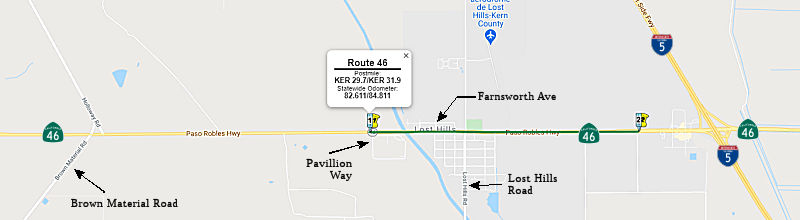 In January 2021, it was announced that Granite Construction had been awarded
a $20 million contract by Caltrans for the Route 46 4-Lane Widening
Project in Lost Hills, California. The project widens Route 46 from a
two-lane to a four-lane highway between KER 29.7 (Pavillion Way, ~0.7 W of
Lost Hills Road) and KER 31.9 (~0.6 mi W of I-5) in Kern County (this
appears to be PPNO 3386D, Seg 4B). Scope of work includes the construction
of two new lanes, a bridge over the California Aqueduct, a high-intensity
activated crosswalk beacon at the Route 46/Bruning Avenue intersection, a
large drainage basin on the west side of Lost Hills Road, as well as curb,
gutter, and crosswalks throughout the town of Lost Hills. Construction
materials for the project will include 117,000 tons of aggregate base,
35,000 tons of hot mix asphalt, and 15,000 tons of rubberized asphalt
concrete. Construction is expected to begin in March 2021 and is expected
to conclude in June 2022.
In January 2021, it was announced that Granite Construction had been awarded
a $20 million contract by Caltrans for the Route 46 4-Lane Widening
Project in Lost Hills, California. The project widens Route 46 from a
two-lane to a four-lane highway between KER 29.7 (Pavillion Way, ~0.7 W of
Lost Hills Road) and KER 31.9 (~0.6 mi W of I-5) in Kern County (this
appears to be PPNO 3386D, Seg 4B). Scope of work includes the construction
of two new lanes, a bridge over the California Aqueduct, a high-intensity
activated crosswalk beacon at the Route 46/Bruning Avenue intersection, a
large drainage basin on the west side of Lost Hills Road, as well as curb,
gutter, and crosswalks throughout the town of Lost Hills. Construction
materials for the project will include 117,000 tons of aggregate base,
35,000 tons of hot mix asphalt, and 15,000 tons of rubberized asphalt
concrete. Construction is expected to begin in March 2021 and is expected
to conclude in June 2022.
(Source: Business Wire, 1/18/2021)
In December 2021, it was reported
that Caltrans was making progress on the long-range project to make that
east-west highway to Paso Robles faster and safer. In fact, just two
sections of about a mile each remain – one through a section of the
Lost Hills oilfield, and the other, under way now, through the tiny little
village of Lost Hills itself. For the town of Lost Hills, it is a mixed
bag. On the plus side, they’ll get a new pedestrian foot bridge,
paid for by the Wonderful Company and already under construction, which
will link the Lost Hills Park on the north side of Route 46, to the south
side, where the Wonderful Academy is located. On the negative side,
however, they fear they’ll see more speed, more automobile accidents
and tougher access to businesses along the route. Gabby’s, a Mexican
restaurant probably familiar to many weekend seabirds, has had a tough
time during construction. “Nah, nothing good,” said
Gabby’s cook Angel Hernandez. At least Gabby’s wasn’t
leveled like Lalo’s Market next door. One of the
residents’ bigger concerns, however, is that the widening will
require Caltrans to make major modifications to the town’s sewer
system. And the townfolk must pay for it, to the tune of $484,000. Vidal
Ballesteros, who owns VB Truck and Diesel, right there on 46, is right in
the middle of it. He’s also the president of the Lost Hills Utility
District, and he says Caltrans is trying to help facilitate a low-interest
loan for the district’s customers but, even with that, residents in
this town where many earn close to minimum wage could see their water
bills jump by $25 a month. The Lost Hills bottleneck will be gone by
Spring 2023, when this work is completed, and the last remaining
bottleneck, at the oil field, will be widened the year after.
(Source: KGET 17, 12/6/2021)
In December 2022, the CTC approved
a request of $18,545,000 for the State-Administered multi-funded TCEP/STIP
Route 46 Expressway Segment 4C project, on the State Highway System, in
Kern County. (06-Ker-46 26.1/30.2, PPNO 3386E; ProjID 0620000053; EA
44256). Route 46 Expressway Segment 4C. In and near Lost
Hills, from 1.3 miles west of Brown Material Road to 0.2 miles east of
California Aquaduct. Convert from a 2-lane conventional highway to a
4-lane divided expressway. CEQA - ND, 05/12/2005; Re-validation
07/28/2022. NEPA - FONSI, 05/12/2005; Re-validation 07/28/2022. Right of
Way Certification: 08/25/2022. Future consideration of funding approved
under Resolution E-06-03; October 2006. Related SHOPP Allocation EA
44257/PPNO 06-8012 under Resolution FP-22-39; December 2022. EA 44256/PPNO
06-3386E combined with SHOPP 44257/PPNO 06-8012 for construction under EA
44256/Project ID 0620000053.
(Source: December 2022 CTC Agenda, Agenda Item
2.5s.(6))
In November 2023, it was reported
that Route 46, which had been closed in Kern County for nearly two months,
reopened days ahead of schedule. The state highway was closed in October
as part of a planned road widening project near Lost Hills. Crews with
Caltrans and Granite Construction completed work ahead of schedule. While
the road is once again in service, the Route 46 Widening Project is not
scheduled to finish until summer 2024.
(Source: Bakersfield.Com, 11/20/2023)
In March 2024, the CTC authorized relinquishment of right of way, consisting of collateral facilities, in the County of Kern (County) along Route 46 on Aloma Street and Lawton Drive (2 segments, 06-Ker-46-PM 32.23/32.32). The County, by letter received on January 22, 2024, agreed to waive the 90-day notice requirement and accept title upon relinquishment by the State. These were two little street segments behind the truck stops.
The James Dean Murals at Lost Hills Road (~ KER 30.489) were made by John
Cerney. Here is a profile of the artist.
(Source: Coachella Valley Independent, 8/13/2021)
J Street Roundabout (06-Ker-46, PM 51.0/51.4)
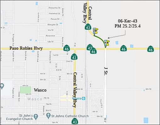 In May 2019, the CTC approved adding the following into the 2018 SHOPP:
Collision Reduction #26: 06-Ker-43 PM 25.2/25.4. PPNO 6982. Proj ID
0618000131. On Route 43 in Wasco, from Route 46 to south of Gromer Avenue.
Improve safety by constructing a roundabout. Timetable: PA&ED:
12/1/2020; R/W: 4/1/2022; RTL: 4/15/2022; BC: 9/20/2022. Est. total:
$10,100K. The CTC also approved the following SHOPP Support Phase
allocation: 06-Ker-43 25.2/25.4. Route 43 In Wasco, from Route 46 to south
of Gromer Avenue. Improve safety by constructing a roundabout. (Concurrent
amendment under SHOPP Amendment 18H-009.) PPNO 6982. ProjID 0618000131.
PA&ED $1,400,000.
In May 2019, the CTC approved adding the following into the 2018 SHOPP:
Collision Reduction #26: 06-Ker-43 PM 25.2/25.4. PPNO 6982. Proj ID
0618000131. On Route 43 in Wasco, from Route 46 to south of Gromer Avenue.
Improve safety by constructing a roundabout. Timetable: PA&ED:
12/1/2020; R/W: 4/1/2022; RTL: 4/15/2022; BC: 9/20/2022. Est. total:
$10,100K. The CTC also approved the following SHOPP Support Phase
allocation: 06-Ker-43 25.2/25.4. Route 43 In Wasco, from Route 46 to south
of Gromer Avenue. Improve safety by constructing a roundabout. (Concurrent
amendment under SHOPP Amendment 18H-009.) PPNO 6982. ProjID 0618000131.
PA&ED $1,400,000.
(Source: May 2019 CTC Minutes, Agenda Item 2.1a.(1)
Item 26; Agenda Item 2.5b.(2a) Item 17)
The 2020 SHOPP, approved in May 2020, included the
following Collision Reduction item of interest (carried over from the 2018
SHOPP): 06-Kern-43 PM 25.2/25.4 PPNO 6982 Proj ID 0618000131 EA 0X770.
Route 43 in Wasco, from Route 46 to south of Gromer Avenue. Improve safety
by constructing a roundabout. Programmed in FY21-22, with construction
scheduled to start in Sept. 2022. Total project cost is $10,100K, with
$5,000K being capital (const and right of way) and $5,100K being support
(engineering, environmental, etc.),
(Source: 2020 Approved SHOPP a/o May 2020)
In June 2021, the CTC amended this project in the
SHOPP: 06-Ker-43 25.2/25.4. PPNO 6982 ProjID 0618000131 EA 06-0X770. Route 43 In Wasco, from Route 46 to south of Gromer Avenue. Improve safety by
constructing a roundabout. Note: Delay construction to FY22-23 due to a
delay to relocate transmission lines that are in conflict with the
roundabout footprint. The delay in relocation is due to the utility
company's required coordination with the California High-Speed Rail
project.
(Source: June 2021 CTC Agenda, Agenda Item
2.1a.(1d) #40)
In December 2021, the CTC approved the following
project for future consideration of funding: 06-Ker-43, PM 25.1/25.3;
06-Ker-46, PM 51.0/51.4. Wasco State Route 43/State Route 46
Intersection Improvements. Construct a single-lane roundabout on a
two-lane roundabout footprint and other improvements at the east junction
intersection of Route 43 and Route 46 and J Street in Kern County. (MND)
(PPNO 6982) (SHOPP). This project is located on Route 43 and Route 46, in
Kern County. The Department proposes to construct a single-lane roundabout
on a two-lane roundabout footprint. Additional improvements include
drainage elements, lighting system, flashing beacon system, traffic
monitoring system, sidewalks and buffers to accommodate pedestrians and
bicyclists. The project is currently programmed in the 2020 SHOPP for a
total of $10,100,000, which includes Construction (capital and support)
and Right of Way (support). Construction is estimated to begin in 2023.
The scope, as described for the preferred alternative, is consistent with
the project scope as programmed by the Commission in the 2020 SHOPP. A
copy of the MND has been provided to Commission staff. The project
will result in less than significant impacts to the environment after
mitigation.
(Source: December 2021 CTC Agenda, Agenda Item
2.2c.(1))
In December 2021, the CTC also approved the following
SHOPP Support Phase allocation: 06-Ker-43 25.2/25.4. PPNO 06-6982; ProjID
0618000131; EA 0X770. Route 43 In Wasco, from Route 46 to south of Gromer
Avenue. Improve safety by constructing a roundabout. (Concurrent
consideration of funding under Resolution E-21-102; December 2021.) (Six
month time extension for PS&E and R/W Sup approved under Waiver
21-59; June 2021.) Allocation: PS&E $1,400,000; R/W SUP $1,000,000.
(Source: December 2021 CTC Agenda, Agenda Item
2.5b.(2a) #6)
Lastly, in December 2021, it was reported that a RAISE
grant (Rebuilding American Infrastructure with Sustainability and Equity,
nee the TIGER grant program) for $24 million will go to the
California High-Speed Rail Authority for the Wasco SR 46 Improvement
Project. This is for improvements to Route 46 where it crosses the
under-construction high-speed rail line. The project will expand about a
half-mile section of the road, lower it to pass safely under existing
railroad tracks and future high-speed rail tracks, and build a roundabout
at the intersection with Route 43. It also includes some sidewalk and ADA
improvements, as well as bike lanes through the area.
(Source: Streetsblog LA, 11/30/2021)
In June 2022, the CTC amended this project in the SHOPP
as follows: 06-Ker-43 25.2/25.4. PPNO 06-6982; ProjID 0618000131; EA
0X770. Route 43 In Wasco, from Route 46 to south of Gromer Avenue.
Improve safety by constructing a roundabout. Note: Delay project due to
acquisition of contaminated parcels required for utility relocations which
need to be completed on an adjacent High Speed Rail Authority (HSR)
project before this project construction can begin. Increase construction
capital due to increases in asphalt quantity. Increase right of way
capital to account for escalation attributed to delivery delay. Amendments
($ × 1,000):FY 22-23 ⇒ 23-24; R/W Cap: $1,100 ⇒ $1,200;
Const Cap $14,900 ⇒ $11,700; TOTAL $24,560 ⇒ $21,360.
(Source: June 2022 CTC Agenda, Agenda Item
2.1a.(1d) #43)
In May 2025, the CTC approved an allocation request for
$9,042,000 for construction of 06-Ker-43 25.2/25.4. PPNO 06-6982; ProjID
0618000131; EA 0X770. Route 43 In Wasco, from Route 46 to south of Gromer
Avenue. Improve safety by constructing a roundabout.This project
will be advertised and constructed with the adjacent California High-Speed
Rail Authority (HSR) project EA 3HT05/Project ID 0622000059 which will
widen the roadway. In May 2019, this project was programmed in the SHOPP
for $3,900,000 in Construction Capital and $1,300,000 in Construction
Support for allocation in Fiscal Year 2021-22. In June 2021, the
project was amended to move out the allocation of the Construction and
Right of Way (RW) Capital phases to 2022-23 due to a delay in relocation
of a utility. In June 2022, the project was amended again to move
out the allocation of the Construction and RW Capital phases to 2023-24
due to a delay in acquisition of parcels, and increase Construction
Capital to $4,400,000 due to an increase in asphalt quantity. In
June 2024, the project requested an allocation time extension for the
Construction phase. However, the request was deferred to the August
2024 meeting and approved for nine months. In January 2025, the
Engineer’s Estimate (EE) reflected the need of $7,542,000 in
Construction Capital (71.4 percent over the programmed amount) and
$1,500,000 in Construction Support (15.4 percent over the programmed
amount). The Department plans to advertise the project in June 2025
and begin construction in October 2025. Construction is planned for
one construction season with a duration of 200 working days. The
Construction Capital estimate is greater than the programmed amount due to
the increase in the footprint of the roundabout to accommodate
oversize/overweight vehicles. In addition, the project encountered
delays due to coordination of utility relocation work and difficulties
with acquiring parcels for the relocation work. The Construction
Support estimate is greater than the programmed amount due to the increase
in working days for the project.
(Source: May 2025 CTC Agenda, Agenda Item 2.5d.(2))
In January 2017, the CTC approved/amended $25,465,000 for a project on Route 46 Near Wasco (06-Ker-46 57.3/57.8), at Route 46/Route 99 Separation Bridge No. 50-0184E from 0.5 mile west of Route 46/Route 99 Separation to 0.1 mile east of Route 46/Route 99 Separation; also on Route 99 from PM R43.9 to 44.6. Outcome/Output: Replace bridge and realign southbound ramps to address structural deficiency and improve functionality and traffic operations. This project has been identified as the first of two pilot projects to include a Tier 4 off road diesel equipment emissions additive bid item.
In May 2022, the CTC authorized relinquishment of right of way,
consisting of collateral facilities, in the county of Kern along Route 46,
west of Route 99 (1 segment, 06-Ker-46-PM 57.6, S side of the road along
Route 46 just before the Route 99 intersection). The County, by
letter dated February 15, 2022, agreed to waive the 90-day notice
requirement and accept title upon relinquishment by the State.
(Source: May 2022 CTC Agenda, Agenda Item 2.3c)
 Double Fine Zones Naming
The segment from US 101 to I-5 is named the "Paso Robles Highway" (~ SLO 29.841 to KER 31.442). It was named by location.
 The interchange at Route 101 and Route 46 East (~ SLO 29.841),
and any subsequent interchange constructed to replace that interchange, in
the City of Paso Robles is named the "California Highway Patrol
Officer Brett J. Oswald Memorial Interchange". It was named in
memory of Officer Brett James Oswald, who was born in 1962, to his parents
Richard and Linda Oswald, in San Rafael, California. Officer Oswald
graduated from Sam Barlow High School in Gresham, Oregon in 1980, received
his associates degree from Central Texas College in Killeen, Texas in
1991, and furthered his education by completing courses at Rio Hondo
Community College in Whittier, California, and Cuesta College, San Luis
Obispo, California. Prior to joining the California Highway Patrol,
Officer Oswald held several jobs, including film development, fabricating
counter tops, custodial work for a local junior high school, military, and
even assisting with his family's business. Officer Oswald, badge number
13164, graduated from the California Highway Patrol Academy in 1990 as a
flight officer, and was assigned to the Santa Fe Springs Area Office.
Officer Oswald subsequently served as a traffic officer in the King City
Area Office, a flight officer in the Paso Robles Coastal Division Air
Operations Office, and a traffic officer in the Templeton Area Office.
Officer Oswald proudly served a total of 20 years and one month as a
California Highway Patrol Officer. Officer Oswald was killed in the line
of duty on June 27, 2010, in Paso Robles, California, when he was struck
by a vehicle while waiting for a tow truck on the side of the road. He
responded to a report that a vehicle had hit a tree on South River Road in
Paso Robles. After investigating, Officer Oswald determined that no
accident had occurred and that the vehicle was abandoned. He called for a
tow truck and was waiting next to his patrol car, when a passing vehicle
crossed the double yellow lines and struck the patrol car. The force of
the impact pushed the patrol car into him. Officer Oswald was transported
to a local hospital where he later died from his injuries. In his spare
time, Officer Oswald enjoyed reading, photography, making people laugh,
working on his property, and a good cigar from time to time. Above all
else, Officer Oswald enjoyed spending time with his family. Named by
Assembly Concurrent Resolution 117, Resolution Chapter 63, June 29, 2012.
The interchange at Route 101 and Route 46 East (~ SLO 29.841),
and any subsequent interchange constructed to replace that interchange, in
the City of Paso Robles is named the "California Highway Patrol
Officer Brett J. Oswald Memorial Interchange". It was named in
memory of Officer Brett James Oswald, who was born in 1962, to his parents
Richard and Linda Oswald, in San Rafael, California. Officer Oswald
graduated from Sam Barlow High School in Gresham, Oregon in 1980, received
his associates degree from Central Texas College in Killeen, Texas in
1991, and furthered his education by completing courses at Rio Hondo
Community College in Whittier, California, and Cuesta College, San Luis
Obispo, California. Prior to joining the California Highway Patrol,
Officer Oswald held several jobs, including film development, fabricating
counter tops, custodial work for a local junior high school, military, and
even assisting with his family's business. Officer Oswald, badge number
13164, graduated from the California Highway Patrol Academy in 1990 as a
flight officer, and was assigned to the Santa Fe Springs Area Office.
Officer Oswald subsequently served as a traffic officer in the King City
Area Office, a flight officer in the Paso Robles Coastal Division Air
Operations Office, and a traffic officer in the Templeton Area Office.
Officer Oswald proudly served a total of 20 years and one month as a
California Highway Patrol Officer. Officer Oswald was killed in the line
of duty on June 27, 2010, in Paso Robles, California, when he was struck
by a vehicle while waiting for a tow truck on the side of the road. He
responded to a report that a vehicle had hit a tree on South River Road in
Paso Robles. After investigating, Officer Oswald determined that no
accident had occurred and that the vehicle was abandoned. He called for a
tow truck and was waiting next to his patrol car, when a passing vehicle
crossed the double yellow lines and struck the patrol car. The force of
the impact pushed the patrol car into him. Officer Oswald was transported
to a local hospital where he later died from his injuries. In his spare
time, Officer Oswald enjoyed reading, photography, making people laugh,
working on his property, and a good cigar from time to time. Above all
else, Officer Oswald enjoyed spending time with his family. Named by
Assembly Concurrent Resolution 117, Resolution Chapter 63, June 29, 2012.
(Image source: CHP 11-99 Foundation)
 The portion of Route 46 from US 101 (~ SLO 29.841 to
SLO 54.945) to Route 41 near Cholame is named the "Jack O'Connell
Highway". Jack O'Connell was a state senator authored the
resolution that made that segment of Route 46 a double-fine zone as part
of an overall safety enforcement effort on the route. Former State
Superintendent of Public Instruction, Jack O’Connell, received a
Bachelor of Arts degree in History from CSU, Fullerton and earned his
secondary teaching credential from CSU, Long Beach in 1975. He returned to
his high school alma mater to teach for several years and later, served on
the Santa Barbara County School Board. Mr. O’Connell was elected to
the 35th State Assembly District in 1982 and was re-elected by wide
margins thereafter. In 1994, Mr. O’Connell was elected to the 18th
State Senate District on California’s Central Coast and easily won
re-election in 1998. He was elected to serve as California’s 26th
State Superintendent on November 5, 2002, earning more votes than any
other contested candidate in the country. With respect to the highway
naming, in 1995, Route 41 and Route 46 from the intersection with US 101
to the intersection with I-5 saw a significant increase in the number of
vehicle accidents involving serious and fatal injuries. Local citizens
along this highway segment expressed concern and outrage over the
increasing number of fatal accidents. A State Senator at the time, Jack
O'Connell initiated action and offered solutions to the highway accidents
in a letter to California Highway Patrol Commissioner Dwight Helmick dated
November 28, 1995. As a result of Senator O'Connell's letter and
subsequent contacts, along with other local constituent actions through
the "Fix 46 Committee," grant funding was requested by the California
Highway Patrol for a special corridor project. Because of the local
concern and the grant request of the California Highway Patrol, the Office
of Traffic Safety provided $100,000 to fund a Route 41 and Route 46
Corridor Task Force, and provide educational material and enforcement
efforts. As part of the safety and enforcement improvements along this
dangerous highway segment, Senator Jack O'Connell authored, in 1996, SB
1367 (Chapter 488 of the Statutes of 1996), which designated Route 46,
between the intersection with US 101 and the junction with Route 41, a
Safety Enhancement-Double Fine Zone. Due to the implementation of the
Route 41 and Route 46 Corridor Task Force's recommendations, there have
been no fatal collisions on this stretch of highway since overall
completion of the project on July 16, 1996 (as of 1997, when the
resolution was authored). Named by Assembly Concurrent Resolution 78,
Chapter 135, in 1997.
The portion of Route 46 from US 101 (~ SLO 29.841 to
SLO 54.945) to Route 41 near Cholame is named the "Jack O'Connell
Highway". Jack O'Connell was a state senator authored the
resolution that made that segment of Route 46 a double-fine zone as part
of an overall safety enforcement effort on the route. Former State
Superintendent of Public Instruction, Jack O’Connell, received a
Bachelor of Arts degree in History from CSU, Fullerton and earned his
secondary teaching credential from CSU, Long Beach in 1975. He returned to
his high school alma mater to teach for several years and later, served on
the Santa Barbara County School Board. Mr. O’Connell was elected to
the 35th State Assembly District in 1982 and was re-elected by wide
margins thereafter. In 1994, Mr. O’Connell was elected to the 18th
State Senate District on California’s Central Coast and easily won
re-election in 1998. He was elected to serve as California’s 26th
State Superintendent on November 5, 2002, earning more votes than any
other contested candidate in the country. With respect to the highway
naming, in 1995, Route 41 and Route 46 from the intersection with US 101
to the intersection with I-5 saw a significant increase in the number of
vehicle accidents involving serious and fatal injuries. Local citizens
along this highway segment expressed concern and outrage over the
increasing number of fatal accidents. A State Senator at the time, Jack
O'Connell initiated action and offered solutions to the highway accidents
in a letter to California Highway Patrol Commissioner Dwight Helmick dated
November 28, 1995. As a result of Senator O'Connell's letter and
subsequent contacts, along with other local constituent actions through
the "Fix 46 Committee," grant funding was requested by the California
Highway Patrol for a special corridor project. Because of the local
concern and the grant request of the California Highway Patrol, the Office
of Traffic Safety provided $100,000 to fund a Route 41 and Route 46
Corridor Task Force, and provide educational material and enforcement
efforts. As part of the safety and enforcement improvements along this
dangerous highway segment, Senator Jack O'Connell authored, in 1996, SB
1367 (Chapter 488 of the Statutes of 1996), which designated Route 46,
between the intersection with US 101 and the junction with Route 41, a
Safety Enhancement-Double Fine Zone. Due to the implementation of the
Route 41 and Route 46 Corridor Task Force's recommendations, there have
been no fatal collisions on this stretch of highway since overall
completion of the project on July 16, 1996 (as of 1997, when the
resolution was authored). Named by Assembly Concurrent Resolution 78,
Chapter 135, in 1997.
(Image source: Impact Teen Drivers)
 The Route 41/Route 46 junction near Cholame (~ SLO 43.888) is
named the "James Dean Memorial Junction". James Byron Dean was one
of the most admired movie stars of all time and an icon of American
culture. He was born on February 8, 1931, in Marion, Indiana; and later
moved to California and attended Santa Monica City College and the
University of California at Los Angeles. He is best known for his roles in
"East of Eden," "Rebel Without a Cause," and "Giant," and also appeared on
television shows and in a Broadway play. As a successful actor, he
attained cult status in little more than a year's time, personifying the
restless American youth of the mid-1950s. He was tragically killed on
September 30, 1955, in an automobile crash on Route 46 in San Luis Obispo
County while traveling in his automobile on the way to a racing event.
Just two hours before the fatal crash, Dean was pulled over for speeding
on Route 99 outside of Bakersfield. Retired officer Otie Hunter clocked
Dean's car at 70 miles an hour. Dean told the officer he had bought the
car just a few days before and was headed to the Monterey area to compete
in a car race. He was given a warning. Around 9:00 PM,
it was reported that James Dean had been killed in a car wreck. This
interchange, which is near where he was killed, is still regularly visited
by his fans. Dean's family, friends, and lawmakers lobbied for the
designation, and on September 30, 2005 (50 years to the day he died), the
state of California posted signs renaming the intersection where he
crashed his silver Porsche, the James Dean Memorial Junction.
Dean's close cousin, Marcus Winslow, accepted an official resolution and
placed a rose at the accident scene. "On September 30,1955, at
approximately 5:45 p.m. only a few feet from where we're standing here,
Jimmy's life came to an abrupt and sorrowful end," said Winslow. Private
donations paid for the two $400 signs, with the hope that the signs will
serve as a safety reminder to drivers. Named by Senate Concurrent
Resolution 52, Chapter 107, on August 15, 2002. Rescinded by ACR 101, Res.
Chapter 53, Statutes of 2026, 4/28/2026, which designated the portion of
Route 46 in the County of San Luis Obispo, from Cholame (SLO 54.038) to
Antelope Road (SLO 58.300) as the “James Dean Memorial Highway”
instead.
The Route 41/Route 46 junction near Cholame (~ SLO 43.888) is
named the "James Dean Memorial Junction". James Byron Dean was one
of the most admired movie stars of all time and an icon of American
culture. He was born on February 8, 1931, in Marion, Indiana; and later
moved to California and attended Santa Monica City College and the
University of California at Los Angeles. He is best known for his roles in
"East of Eden," "Rebel Without a Cause," and "Giant," and also appeared on
television shows and in a Broadway play. As a successful actor, he
attained cult status in little more than a year's time, personifying the
restless American youth of the mid-1950s. He was tragically killed on
September 30, 1955, in an automobile crash on Route 46 in San Luis Obispo
County while traveling in his automobile on the way to a racing event.
Just two hours before the fatal crash, Dean was pulled over for speeding
on Route 99 outside of Bakersfield. Retired officer Otie Hunter clocked
Dean's car at 70 miles an hour. Dean told the officer he had bought the
car just a few days before and was headed to the Monterey area to compete
in a car race. He was given a warning. Around 9:00 PM,
it was reported that James Dean had been killed in a car wreck. This
interchange, which is near where he was killed, is still regularly visited
by his fans. Dean's family, friends, and lawmakers lobbied for the
designation, and on September 30, 2005 (50 years to the day he died), the
state of California posted signs renaming the intersection where he
crashed his silver Porsche, the James Dean Memorial Junction.
Dean's close cousin, Marcus Winslow, accepted an official resolution and
placed a rose at the accident scene. "On September 30,1955, at
approximately 5:45 p.m. only a few feet from where we're standing here,
Jimmy's life came to an abrupt and sorrowful end," said Winslow. Private
donations paid for the two $400 signs, with the hope that the signs will
serve as a safety reminder to drivers. Named by Senate Concurrent
Resolution 52, Chapter 107, on August 15, 2002. Rescinded by ACR 101, Res.
Chapter 53, Statutes of 2026, 4/28/2026, which designated the portion of
Route 46 in the County of San Luis Obispo, from Cholame (SLO 54.038) to
Antelope Road (SLO 58.300) as the “James Dean Memorial Highway”
instead.
(Image sources: Reddit, History Channel)
 Additionally, the portion of Route 46 in the County of
San Luis Obispo, from Cholame (SLO 54.038) to Antelope Road (SLO 58.300)
is designated the “James Dean Memorial Highway”; the
naming resolution also rescinded the designation of the James Dean
Memorial Junction. Dean's biography is above. Additionally, the naming
resolution notes: As a successful actor, he attained cult status in little
more than a year’s time, personifying the restless American youth of
the mid-1950s. He was tragically killed on September 30, 1955, in an
automobile crash on Route 46 in the County of San Luis Obispo while
traveling in his automobile on the way to a racing event. Many decades
after his death, James Dean remains widely admired as an accomplished
actor, and it is appropriate to recognize his contributions through a
designation of a memorial highway near the site of his untimely death. The
Legislature, through the adoption of Senate Concurrent Resolution 52
(Resolution Chapter 107 of the Statutes of 2002), designated the junction
of Route 41 and Route 46 near Cholame in the County of San Luis Obispo as
the James Dean Memorial Junction. However, in ACR 101, the designation in
honor of James Dean made by Senate Concurrent Resolution 52 (Resolution
Chapter 107 of the Statutes of 2002) designating the junction of Route 41
and Route 46 near Cholame in the County of San Luis Obispo as the James
Dean Memorial Junction is rescinded; and the Legislature designated the
portion of Route 46 in the County of San Luis Obispo, from Cholame, at
postmile 54.038, to Antelope Road, at postmile 58.300, as the James Dean
Memorial Highway. Named by ACR 101, Res. Chapter 53, Statutes of 2026,
4/28/2026.
Additionally, the portion of Route 46 in the County of
San Luis Obispo, from Cholame (SLO 54.038) to Antelope Road (SLO 58.300)
is designated the “James Dean Memorial Highway”; the
naming resolution also rescinded the designation of the James Dean
Memorial Junction. Dean's biography is above. Additionally, the naming
resolution notes: As a successful actor, he attained cult status in little
more than a year’s time, personifying the restless American youth of
the mid-1950s. He was tragically killed on September 30, 1955, in an
automobile crash on Route 46 in the County of San Luis Obispo while
traveling in his automobile on the way to a racing event. Many decades
after his death, James Dean remains widely admired as an accomplished
actor, and it is appropriate to recognize his contributions through a
designation of a memorial highway near the site of his untimely death. The
Legislature, through the adoption of Senate Concurrent Resolution 52
(Resolution Chapter 107 of the Statutes of 2002), designated the junction
of Route 41 and Route 46 near Cholame in the County of San Luis Obispo as
the James Dean Memorial Junction. However, in ACR 101, the designation in
honor of James Dean made by Senate Concurrent Resolution 52 (Resolution
Chapter 107 of the Statutes of 2002) designating the junction of Route 41
and Route 46 near Cholame in the County of San Luis Obispo as the James
Dean Memorial Junction is rescinded; and the Legislature designated the
portion of Route 46 in the County of San Luis Obispo, from Cholame, at
postmile 54.038, to Antelope Road, at postmile 58.300, as the James Dean
Memorial Highway. Named by ACR 101, Res. Chapter 53, Statutes of 2026,
4/28/2026.
(Image source: Weird California)
The segment from I-5 to Route 99 is named the "Famosa Highway" (~ KER 32.754 to KER 57.688). It was named by location.
 The portion of Route 46 within the city limits of the City of
Wasco (~KER 46.046 to KER 51.561) is named the "Medal of Honor
Recipient Larry Stanley Pierce Memorial Highway". It is named in
memory of Larry Stanley Pierce, born on July 6, 1941, in Wewoka, Oklahoma.
In 1958, Larry Stanley Pierce enlisted in the United States Army, where he
rose to the rank of Staff Sergeant and served in the 1st Battalion of the
173rd Airborne Brigade. Larry Stanley Pierce served his country in the
Republic of Vietnam during the Vietnam War and was assigned as a squad
leader in charge of a reconnaissance platoon. On September 20, 1965, Larry
Stanley Pierce and his platoon were ambushed by hostile forces with
machine gun fire. Pierce and his platoon routed the ambushing force and
gave chase in order to further suppress the attacking enemy. Pierce
discovered an antipersonnel mine that could have destroyed his entire
squad. He used his own body to absorb the blast from the mine, saving the
lives of 29 of his soldiers. Larry Stanley Pierce was laid to rest at the
Wasco Memorial Park in the City of Wasco, California, and President Lyndon
B. Johnson posthumously awarded the Medal of Honor to Larry Stanley
Pierce's wife, Verlin, his daughter, Teresa, and his sons, Kelley and
Gregory, on February 14, 1966. Named by Assembly Concurrent Resolution
(ACR) 60, Resolution Chapter 68, on 7/16/2009.
The portion of Route 46 within the city limits of the City of
Wasco (~KER 46.046 to KER 51.561) is named the "Medal of Honor
Recipient Larry Stanley Pierce Memorial Highway". It is named in
memory of Larry Stanley Pierce, born on July 6, 1941, in Wewoka, Oklahoma.
In 1958, Larry Stanley Pierce enlisted in the United States Army, where he
rose to the rank of Staff Sergeant and served in the 1st Battalion of the
173rd Airborne Brigade. Larry Stanley Pierce served his country in the
Republic of Vietnam during the Vietnam War and was assigned as a squad
leader in charge of a reconnaissance platoon. On September 20, 1965, Larry
Stanley Pierce and his platoon were ambushed by hostile forces with
machine gun fire. Pierce and his platoon routed the ambushing force and
gave chase in order to further suppress the attacking enemy. Pierce
discovered an antipersonnel mine that could have destroyed his entire
squad. He used his own body to absorb the blast from the mine, saving the
lives of 29 of his soldiers. Larry Stanley Pierce was laid to rest at the
Wasco Memorial Park in the City of Wasco, California, and President Lyndon
B. Johnson posthumously awarded the Medal of Honor to Larry Stanley
Pierce's wife, Verlin, his daughter, Teresa, and his sons, Kelley and
Gregory, on February 14, 1966. Named by Assembly Concurrent Resolution
(ACR) 60, Resolution Chapter 68, on 7/16/2009.
(Image source: Find a Grave)
 Named Structures
This route also has the following Safety Roadside Rest Areas:
 Jesse L. Acebedo Memorial Rest Area, in Shandon in San Luis Obispo County, 0.9 mi E of Route 41 (SLO 49.599). It was named in
memory of Jesse LaMadrid Acebedo, born in November 1948, in Delano and
raised in McFarland, in the County of Kern, where he attended schools
and graduated from high school in 1967. In 1970, Jesse began his law
enforcement career with the Wasco Police Department, but shortly
afterwards, he joined the Kern County Sheriff’s Department, and
the western area of the County of Kern continued to be his beat until
his retirement in 2004. Some of his career highlights included travel
to Mexico to bring back three homicide eyewitnesses, as well as
participating in America’s Most Wanted in Washington, D.C.
involving a kidnapping in the County of Kern. Jesse’s life was
one of public service, not just through his work, but also through all
of his causes, which included coaching Little League, Babe Ruth
League, and soccer, or being the announcer for the Wasco Union High
School football games. For several years, Jesse was also a recruiter
of underprivileged boys who attended the R.M. Pyles Boys Camp and in
2010, Jesse started the Kern County Student Leadership program at
Wasco Union High School, which is still going strong. Jesse was very
involved with St. John’s Catholic School, where he served twice
as their school board president, was first elected to the Wasco Union
High School Board in the early ‘90s, went on to serve on the
Kern County Board of Education, and in 2006, he was again elected to
the Wasco Union High School Board, where he served two more terms.
Jesse was a past member of the Wasco Festival of Roses board for
several years, where he served as president more than once and also
served on the Wasco Housing Authority. Jesse at 68 years of age was
driving west on Route 46 just after 2 p.m. on March 31, 2017, when a
semitruck hit him head-on, just after he had passed the Shandon rest
area. During his lifetime, Jesse touched many lives from all walks of
life. Whether people agreed with him or not, they knew where they
stood with Jesse because he was always a straight shooter. Jesse
didn’t focus on people’s position, money, status, or
titles, just the person, a testament to which is all the people who
attended his celebration of life at the historic Wasco Union High
School Auditorium, which seats 1,182 and was almost full. The City of
Bakersfield was Jesse’s residence at the time of his passing,
but the Wasco community was home and where his legacy of giving back
remains. Named by Assembly Concurrent Resolution (ACR) 201, Res.
Chapter 188, 9/5/2018.
Jesse L. Acebedo Memorial Rest Area, in Shandon in San Luis Obispo County, 0.9 mi E of Route 41 (SLO 49.599). It was named in
memory of Jesse LaMadrid Acebedo, born in November 1948, in Delano and
raised in McFarland, in the County of Kern, where he attended schools
and graduated from high school in 1967. In 1970, Jesse began his law
enforcement career with the Wasco Police Department, but shortly
afterwards, he joined the Kern County Sheriff’s Department, and
the western area of the County of Kern continued to be his beat until
his retirement in 2004. Some of his career highlights included travel
to Mexico to bring back three homicide eyewitnesses, as well as
participating in America’s Most Wanted in Washington, D.C.
involving a kidnapping in the County of Kern. Jesse’s life was
one of public service, not just through his work, but also through all
of his causes, which included coaching Little League, Babe Ruth
League, and soccer, or being the announcer for the Wasco Union High
School football games. For several years, Jesse was also a recruiter
of underprivileged boys who attended the R.M. Pyles Boys Camp and in
2010, Jesse started the Kern County Student Leadership program at
Wasco Union High School, which is still going strong. Jesse was very
involved with St. John’s Catholic School, where he served twice
as their school board president, was first elected to the Wasco Union
High School Board in the early ‘90s, went on to serve on the
Kern County Board of Education, and in 2006, he was again elected to
the Wasco Union High School Board, where he served two more terms.
Jesse was a past member of the Wasco Festival of Roses board for
several years, where he served as president more than once and also
served on the Wasco Housing Authority. Jesse at 68 years of age was
driving west on Route 46 just after 2 p.m. on March 31, 2017, when a
semitruck hit him head-on, just after he had passed the Shandon rest
area. During his lifetime, Jesse touched many lives from all walks of
life. Whether people agreed with him or not, they knew where they
stood with Jesse because he was always a straight shooter. Jesse
didn’t focus on people’s position, money, status, or
titles, just the person, a testament to which is all the people who
attended his celebration of life at the historic Wasco Union High
School Auditorium, which seats 1,182 and was almost full. The City of
Bakersfield was Jesse’s residence at the time of his passing,
but the Wasco community was home and where his legacy of giving back
remains. Named by Assembly Concurrent Resolution (ACR) 201, Res.
Chapter 188, 9/5/2018.
(Image sources: Bakersfield.com)
 In August 2023, it was reported that Caltrans
District 5 unveiled the District 5 Fallen Highway Workers Memorial. at the Shandon Roadside Rest Area on
Route 46 East to honor the eight workers who died in the line of duty
on the Central Coast and to encourage travelers to drive responsibly.
In August 2023, it was reported that Caltrans
District 5 unveiled the District 5 Fallen Highway Workers Memorial. at the Shandon Roadside Rest Area on
Route 46 East to honor the eight workers who died in the line of duty
on the Central Coast and to encourage travelers to drive responsibly.
(Source: District 5 on X/Twitter, 8/15/2023)
 Other WWW Links Scenic Route
[SHC 263.4] From Route 101 near Paso Robles to Route 41 near Cholame.
Although this segment is eligible for Scenic Highway status, it has not yet met the criteria to be officially designated as Scenic Highway.
 Freeway
[SHC 253.4] Entire portion. Added to the Freeway and Expressway system in 1959.
 Interregional Route Other WWW Links
 Statistics
Overall statistics for Route 46:
 Pre-1964 Legislative Route
The route that would become LRN 46 was first defined in the 1919 Third Bond Issue as running from Klamath River Bridge [LRN 3] to [LRN 1] near Klamath River. This was captured in the 1935 highway code as:
In 1949, Chapter 909 change the origin to be "a point on [LRN 3] near the Klamath River Bridge". In 1959, Chapter 435 added the following words permitting the route to be non-continuous:
Notwithstanding the provisions of Section 81 of this code, the department may maintain a traversable highway located in portions of this area between the termini of and approximately on this route even though the highway is not continuous.
This is present-day (partially unconstructed, route not determined) Route 169 between US 101 (LRN 1) near Klamath and Weitchpec. It is Route 96 between Weitchpec and the vicinty of Hawkinsville. Present-day I-5 bypasses the old US 99 route (LRN 3), which is now signed as Route 263.
© 1996-2024 Daniel P. Faigin.
Maintained by: Daniel P. Faigin
<webmaster@cahighways.org>.

 Route 45
 Route 47