
 California Highways:
Click here for a key to the symbols used. An explanation of acronyms may be found at the bottom of the page.
 Routing
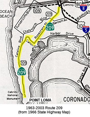 No current routing.
 Post 1964 Signage History
 In 1963, Route 209 was defined as "Point Loma to Route 5 in San
Diego."
In 2003, Chapter 525 deleted Route 209.
In 1966, CHPW announced funding for construction of the Route 209 freeway
was earmarked for the 1967-1968 fiscal year. This freeway construction
never happened.
(Source: Gribblenation Blog (Tom Fearer), "The history of US Route 80 and Interstate 8 in California", June 2024)
 Pre 1964 Signage History
This was originally part of LRN 12. It was defined in 1933. This does not appear to have been signed as US 80, or with a state sign route shield.
The 1953 State Highway Map shows the Point Loma segment, as LRN 12,
running along Cabrillo Memorial Dr, Catalina Blvd, Cañon Street,
Rosecrans, and Barnett to end at Pacific Highway (then US 101). US 80
started at Pacific Highway and Market, continued along Market and up the
Cabrillo Freeway (now Route 163) cosigned with US 395, and then continued
(now as LRN 12) E along Washington, Norma, and then El Cajon. Prior to the
Cabrillo Freeway, US 80 and US 395 ran down Park to meet US 101 at Market.
By the 1954 map, the Point Loma segment has been routed off Barnett and
onto Camino Del Rio from Rosecrans, ending at US 395. The future I-8 has
been constructed along roughly Camino Del Rio, and USGS maps show it as US 80 to US 101 (although the state highway map shows US 80 starting
un-cosigned at US 395 and continuing E along El Cajon). By 1955, the state
highway map shows US 80 now routed off El Cajon and onto Camino Del Rio /
Future I-8, and feeding into the Point Loma segment as a unified LRN 12.
No maps (USGS, State Highway Maps, or others available online) show the
Point Loma segment with clear US 80 signage. E of US 101, US 80 does not
share signage with US 395.
(Source: Research for CARouteByRoute Podcast, Ep. 4.01)
There is a debate on whether US 80 continued W from San Diego to Point
Loma (note that this is not the current I-8 routing W of I-5 to Ocean
Beach, which was Route 109). As originally defined, US 80 terminated in
"San Diego" via LRN 12 and the Old Spanish Trail. The termination point
was imprecise, and maps show it as US 101, although for much of the time,
the portion from Park or the Cabrillo Freeway was cosigned with US 395 to
Market and thence to US 101. At the time of definition, the imprecise
definition was sufficient as the state could not maintain highways within
large urban areas. The 1930 state highway map inferred that US 80
terminated in downtown San Diego at US 101/Broadway via 4th
Street. In 1931, San Diego County was advocating for US 80 to terminate in
Point Loma (making the highway truly coast to coast). In 1933, when the
state could take over highways in large cities, LRN 12 was extended to
Point Loma: "Atlantic Street, San Diego to old Spanish Lighthouse, Point
Loma". On July 16, 1934, the modernized highway carrying LRN 12 to Point
Loma was dedicated and ended at the Old Spanish Lighthouse parking area.
This segment was larger that Route 209. However, although some commercial
maps showed US 80 as extended to Point Loma, no state highway maps
included that extension. Throughout the 1930s and 1940s, according to
state highway maps, US 80 terminated at US 101. The first reference of US 80 terminating at Point Loma was in the July/August 1955 California
Highways & Public Works, which refers to Rosecrans Boulevard/LRN 12
between Lytton Street and Pacific Highway as part of US 80. Additionally,
the November/December 1958 California Highways & Public Works
specifically states US 80 ended at the Old Spanish Lighthouse at Point
Loma. However, there appears to be no formal request of AASHO
(although it is likely that "San Diego" was close enough for government
work). Muddying the waters is the fact that the May/June 1961 California
Highways & Public Works describes the freeway corridor of US 80 as
ending at US 101, and USGS maps of the era show US 80 terminating at US 101. Additionally, when Route 209 was created in 1964 for the
portion of LRN 12 W of US 101, the 1964 Division of Highways Map depicted
Route 209 as ending at Point Loma, but the map does not clearly convey the
status of US 80 beyond US 101 (the 1964 map still showed the US highways). In 1966, AASHO approved a request by the DOH to truncate
US 80 to the Arizona State Line. The DOH Map submitted with the
request depicted US 80 terminating at Point Loma. The specific
status remains unclear.
(Source: Gribblenation Blog (Tom Fearer), "US Route 80 to Point Loma?", July 2022)
 Status
The Gate at the Fort Rosecrans Military Reservation is open daily from 8:00am to 5:15pm. As signs get replaced on I-5, references to Route 209 are disappearing; however, Route 209 is still well marked upon Rosecrans.
 Other WWW Links
 Scenic Route
[SHC 263.1] Entire route: Pt Loma to I-5 in San Diego (All)
Although this segment was eligible for Scenic Highway status, it had not yet met the criteria to be officially designated as Scenic Highway by the time the route was deleted.
 Statistics
Overall statistics for Route 209:
 Pre-1964 Legislative Route
In 1939, Chapter 794 added the route “[LRN 3] near Station 398, according to the survey of said [LRN 3], Section B, to Shasta Summit near Summit City”. No route number was assigned. This route was added as an urgency measure, in order to accomodate heavy traffic from US 99 to and from Shasta Dam.
In 1943, Chapter 964 amended the 1939 definition to specify this as LRN 209.
In 1953, Chapter 1836 rewrote the routing: "[LRN 3] near Project City to Shasta Dam"
This is present-day Route 151.
© 1996-2024 Daniel P. Faigin.
Maintained by: Daniel P. Faigin
<webmaster@cahighways.org>.

 Route 208
 Route 210